Category:Sanborn Fire Insurance Map from Glendive, Dawson County, Montana, 1910
See parent category for index.
Media in category "Sanborn Fire Insurance Map from Glendive, Dawson County, Montana, 1910"
The following 9 files are in this category, out of 9 total.
-
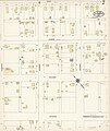
 Sanborn Fire Insurance Map from Glendive, Dawson County, Montana, 1910, Plate 0001.jpg 6,450 × 7,650; 3.26 MB
-
 Sanborn Fire Insurance Map from Glendive, Dawson County, Montana, 1910, Plate 0002.jpg 6,450 × 7,650; 3.17 MB
-
 Sanborn Fire Insurance Map from Glendive, Dawson County, Montana, 1910, Plate 0003.jpg 6,450 × 7,650; 3.21 MB
-
 Sanborn Fire Insurance Map from Glendive, Dawson County, Montana, 1910, Plate 0004.jpg 6,450 × 7,650; 3.44 MB
-
 Sanborn Fire Insurance Map from Glendive, Dawson County, Montana, 1910, Plate 0005.jpg 6,450 × 7,650; 3.01 MB
-
 Sanborn Fire Insurance Map from Glendive, Dawson County, Montana, 1910, Plate 0006.jpg 6,450 × 7,650; 2.75 MB
-
 Sanborn Fire Insurance Map from Glendive, Dawson County, Montana, 1910, Plate 0007.jpg 6,450 × 7,650; 2.77 MB
-
 Sanborn Fire Insurance Map from Glendive, Dawson County, Montana, 1910, Plate 0008.jpg 6,450 × 7,650; 2.81 MB
-
 Sanborn Fire Insurance Map from Glendive, Dawson County, Montana, 1910, Plate 0009.jpg 6,450 × 7,650; 2.84 MB


