Category:Sanborn Fire Insurance Map from Greenville, Mublenberg County, Kentucky
Media in category "Sanborn Fire Insurance Map from Greenville, Mublenberg County, Kentucky"
The following 12 files are in this category, out of 12 total.
-

-
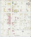
 Sanborn Fire Insurance Map from Greenville, Mublenberg County, Kentucky. LOC sanborn03174 001-1.tif 6,450 × 7,650; 141.17 MB
-

-
 Sanborn Fire Insurance Map from Greenville, Mublenberg County, Kentucky. LOC sanborn03174 001-2.tif 6,450 × 7,650; 141.17 MB
-

-
 Sanborn Fire Insurance Map from Greenville, Mublenberg County, Kentucky. LOC sanborn03174 002-1.tif 6,450 × 7,650; 141.17 MB
-

-
 Sanborn Fire Insurance Map from Greenville, Mublenberg County, Kentucky. LOC sanborn03174 002-2.tif 6,450 × 7,650; 141.17 MB
-

-
 Sanborn Fire Insurance Map from Greenville, Mublenberg County, Kentucky. LOC sanborn03174 003-1.tif 6,450 × 7,650; 141.17 MB
-

-
 Sanborn Fire Insurance Map from Greenville, Mublenberg County, Kentucky. LOC sanborn03174 003-2.tif 6,450 × 7,650; 141.17 MB


