Category:Sanborn Fire Insurance Map from Odell, Gage County, Nebraska, 1941
See parent category for index.
Media in category "Sanborn Fire Insurance Map from Odell, Gage County, Nebraska, 1941"
The following 4 files are in this category, out of 4 total.
-
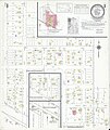 Sanborn Fire Insurance Map from Odell, Gage County, Nebraska, 1941, Plate 0001.jpg 6,450 × 7,650; 4.02 MB
-
 Sanborn Fire Insurance Map from Odell, Gage County, Nebraska, 1941, Plate 0001.tiff 6,450 × 7,650; 141.17 MB
-
 Sanborn Fire Insurance Map from Odell, Gage County, Nebraska, 1941, Plate 0002.jpg 6,450 × 7,650; 2.95 MB
-
 Sanborn Fire Insurance Map from Odell, Gage County, Nebraska, 1941, Plate 0002.tiff 6,450 × 7,650; 141.17 MB

