Category:Sanborn Fire Insurance Map from San Angelo, Tom Green County, Texas, 1920
See parent category for index.
Media in category "Sanborn Fire Insurance Map from San Angelo, Tom Green County, Texas, 1920"
The following 36 files are in this category, out of 36 total.
-
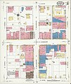
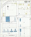
 Sanborn Fire Insurance Map from San Angelo, Tom Green County, Texas, 1920, Plate 001.jpg 6,450 × 7,650; 4.25 MB
-
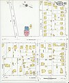
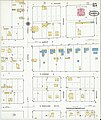
 Sanborn Fire Insurance Map from San Angelo, Tom Green County, Texas, 1920, Plate 002.jpg 6,450 × 7,650; 3.14 MB
-
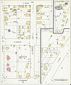
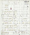
 Sanborn Fire Insurance Map from San Angelo, Tom Green County, Texas, 1920, Plate 003.jpg 6,450 × 7,650; 3.53 MB
-
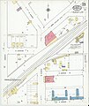
 Sanborn Fire Insurance Map from San Angelo, Tom Green County, Texas, 1920, Plate 004.jpg 6,450 × 7,650; 3.38 MB
-
 Sanborn Fire Insurance Map from San Angelo, Tom Green County, Texas, 1920, Plate 005.jpg 6,450 × 7,650; 2.76 MB
-
 Sanborn Fire Insurance Map from San Angelo, Tom Green County, Texas, 1920, Plate 006.jpg 6,450 × 7,650; 2.97 MB
-
 Sanborn Fire Insurance Map from San Angelo, Tom Green County, Texas, 1920, Plate 007.jpg 6,450 × 7,650; 2.69 MB
-

-
 Sanborn Fire Insurance Map from San Angelo, Tom Green County, Texas, 1920, Plate 009.jpg 6,450 × 7,650; 2.98 MB
-
 Sanborn Fire Insurance Map from San Angelo, Tom Green County, Texas, 1920, Plate 010.jpg 6,450 × 7,650; 2.97 MB
-
 Sanborn Fire Insurance Map from San Angelo, Tom Green County, Texas, 1920, Plate 011.jpg 6,450 × 7,650; 2.87 MB
-
 Sanborn Fire Insurance Map from San Angelo, Tom Green County, Texas, 1920, Plate 012.jpg 6,450 × 7,650; 2.76 MB
-
 Sanborn Fire Insurance Map from San Angelo, Tom Green County, Texas, 1920, Plate 013.jpg 6,450 × 7,650; 2.75 MB
-
 Sanborn Fire Insurance Map from San Angelo, Tom Green County, Texas, 1920, Plate 014.jpg 6,450 × 7,650; 2.91 MB
-
 Sanborn Fire Insurance Map from San Angelo, Tom Green County, Texas, 1920, Plate 015.jpg 6,450 × 7,650; 2.89 MB
-
 Sanborn Fire Insurance Map from San Angelo, Tom Green County, Texas, 1920, Plate 016.jpg 6,450 × 7,650; 2.85 MB
-
 Sanborn Fire Insurance Map from San Angelo, Tom Green County, Texas, 1920, Plate 017.jpg 6,450 × 7,650; 2.84 MB
-
 Sanborn Fire Insurance Map from San Angelo, Tom Green County, Texas, 1920, Plate 018.jpg 6,450 × 7,650; 2.72 MB
-
 Sanborn Fire Insurance Map from San Angelo, Tom Green County, Texas, 1920, Plate 019.jpg 6,450 × 7,650; 2.88 MB
-
 Sanborn Fire Insurance Map from San Angelo, Tom Green County, Texas, 1920, Plate 020.jpg 6,450 × 7,650; 2.9 MB
-
 Sanborn Fire Insurance Map from San Angelo, Tom Green County, Texas, 1920, Plate 021.jpg 6,450 × 7,650; 3.05 MB
-
 Sanborn Fire Insurance Map from San Angelo, Tom Green County, Texas, 1920, Plate 022.jpg 6,450 × 7,650; 2.63 MB
-
 Sanborn Fire Insurance Map from San Angelo, Tom Green County, Texas, 1920, Plate 023.jpg 6,450 × 7,650; 2.76 MB
-
 Sanborn Fire Insurance Map from San Angelo, Tom Green County, Texas, 1920, Plate 024.jpg 6,450 × 7,650; 2.73 MB
-
 Sanborn Fire Insurance Map from San Angelo, Tom Green County, Texas, 1920, Plate 025.jpg 6,450 × 7,650; 2.82 MB
-
 Sanborn Fire Insurance Map from San Angelo, Tom Green County, Texas, 1920, Plate 026.jpg 6,450 × 7,650; 2.6 MB
-
 Sanborn Fire Insurance Map from San Angelo, Tom Green County, Texas, 1920, Plate 027.jpg 6,450 × 7,650; 3.31 MB
-
 Sanborn Fire Insurance Map from San Angelo, Tom Green County, Texas, 1920, Plate 028.jpg 6,450 × 7,650; 3.21 MB
-
 Sanborn Fire Insurance Map from San Angelo, Tom Green County, Texas, 1920, Plate 029.jpg 6,450 × 7,650; 3.2 MB
-
 Sanborn Fire Insurance Map from San Angelo, Tom Green County, Texas, 1920, Plate 030.jpg 6,450 × 7,650; 3.47 MB
-
 Sanborn Fire Insurance Map from San Angelo, Tom Green County, Texas, 1920, Plate 031.jpg 6,450 × 7,650; 3.55 MB
-
 Sanborn Fire Insurance Map from San Angelo, Tom Green County, Texas, 1920, Plate 032.jpg 6,450 × 7,650; 3.35 MB
-
 Sanborn Fire Insurance Map from San Angelo, Tom Green County, Texas, 1920, Plate 033.jpg 6,450 × 7,650; 3.77 MB
-
 Sanborn Fire Insurance Map from San Angelo, Tom Green County, Texas, 1920, Plate 034.jpg 6,450 × 7,650; 3.46 MB
-
 Sanborn Fire Insurance Map from San Angelo, Tom Green County, Texas, 1920, Plate 035.jpg 6,450 × 7,650; 3.25 MB
-
 Sanborn Fire Insurance Map from San Angelo, Tom Green County, Texas, 1920, Plate titl.jpg 6,450 × 7,650; 3.69 MB


