Category:Sanborn maps of the Bronx published in 1908, V. B
Maps from: Insurance Maps of the City of New York Borough of the Bronx. Volume B. (New York: Sanborn Map Company, 1908), comprising title page, street index, key to house numbers, and volume key, plus 54 numbered plates (maps) and two enlargements supplementing Plates 48 and 49 respectively. Missing from this category are the street index and Plates 2–4, 25–27, 29–32, and 35–40.
Source: The New York Public Library Digital Collections website, Vol. B
Media in category "Sanborn maps of the Bronx published in 1908, V. B"
The following 43 files are in this category, out of 43 total.
-

-
 Key Plan NYPL2021134.tiff 5,398 × 7,197, 2 pages; 111.21 MB
-
 Key Plan Continued NYPL2021135.tiff 5,371 × 7,162, 2 pages; 110.11 MB
-
 Bronx, V. B, Plate No. 1 (Map bounded by Mace Ave., Cruger Ave., Reiss Pl., Bronx Park E.) NYPL2021136.tiff 5,398 × 7,197, 2 pages; 111.21 MB
-
 Bronx, V. B, Plate No. 5 (Map bounded by Tilden St., South Oak Drive, White Plains Rd.) NYPL2021140.tiff 5,384 × 7,179, 2 pages; 110.64 MB
-
 Bronx, V. B, Plate No. 6 (Map bounded by Tilden St., Boston Rd., Williamsbridge Rd., South Oak Drive) NYPL2021141.tiff 5,406 × 7,208, 2 pages; 111.54 MB
-
 Bronx, V. B, Plate No. 7 (Map bounded by Bronx River, White Plains Rd., Rosewood St., Newell Ave.) NYPL2021142.tiff 5,409 × 7,211, 2 pages; 111.65 MB
-
 Bronx, V. B, Plate No. 8 (Map bounded by Bronx River, Willett Ave., Gun Hill Rd., E. 219th St.) NYPL2021143.tiff 5,406 × 7,208, 2 pages; 111.54 MB
-
 Bronx, V. B, Plate No. 9 (Map bounded by Willett Ave., E. 215th St., Bronxwood Ave., Tilden St.) NYPL2021144.tiff 5,409 × 7,211, 2 pages; 111.65 MB
-
 Bronx, V. B, Plate No. 10 (Map bounded by Willett Ave., E. 219th St., Bronxwood Ave., E. 215th St.) NYPL2021145.tiff 5,387 × 7,183, 2 pages; 110.76 MB
-
 Bronx, V. B, Plate No. 11 (Map bounded by E. 220th St., Tilden St., Bronxwood Ave.) NYPL2021146.tiff 5,412 × 7,216, 2 pages; 111.79 MB
-
 Bronx, V. B, Plate No. 12 (Map bounded by Eastchester Rd., Boston Rd., Briggs Ave., Oakley St.) NYPL2021147.tiff 5,387 × 7,183, 2 pages; 110.76 MB
-
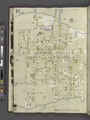
 Bronx, V. B, Plate No. 13 (Map bounded by E. 228th St., E. 220th St., Bronxwood Ave.) NYPL2021148.tiff 5,383 × 7,177, 2 pages; 110.59 MB
-
 Bronx, V. B, Plate No. 14 (Map bounded by Oakley St., Eastchester Rd.) NYPL2021149.tiff 5,387 × 7,183, 2 pages; 110.76 MB
-
 Bronx, V. B, Plate No. 15 (Map bounded by White Plains Rd., E. 224th St., Bronxwood Ave., E. 219th St.) NYPL2021150.tiff 5,383 × 7,177, 2 pages; 110.59 MB
-
 Bronx, V. B, Plate No. 16 (Map bounded by Bronx River, E. 224th St., White Plains Rd., E. 219th St.) NYPL2021151.tiff 5,387 × 7,183, 2 pages; 110.76 MB
-
 Bronx, V. B, Plate No. 17 (Map bounded by Carpenter Ave., E. 229th St., Barnes Ave., E. 224th St.) NYPL2021152.tiff 5,383 × 7,177, 2 pages; 110.59 MB
-
 Bronx, V. B, Plate No. 18 (Map bounded by Carpenter Ave., E. 234th St., Barnes Ave., E. 229th St.) NYPL2021153.tiff 5,387 × 7,183, 2 pages; 110.76 MB
-
 Bronx, V. B, Plate No. 19 (Map bounded by Barnes Ave., E. 233rd St., Bronxwood Ave., E. 224th St.) NYPL2021154.tiff 5,383 × 7,177, 2 pages; 110.59 MB
-
 Bronx, V. B, Plate No. 20 (Map bounded by Bronxwood Ave., E. 233rd St., Ely Ave., E. 228th St.) NYPL2021155.tiff 5,387 × 7,183, 2 pages; 110.76 MB
-
 Bronx, V. B, Plate No. 21 (Map bounded by E. 239th St., Wickham Ave., Bussing Ave., White Plains Rd.) NYPL2021156.tiff 5,383 × 7,177, 2 pages; 110.59 MB
-
 Bronx, V. B, Plate No. 22 (Map bounded by Bussing Ave., Grace Ave., E. 233rd St., Digney Ave.) NYPL2021157.tiff 5,387 × 7,183, 2 pages; 110.76 MB
-
 Bronx, V. B, Plate No. 23 (Map bounded by Bronx River, E. 237th St., Old White Plains Rd., E. 234th St.) NYPL2021158.tiff 5,357 × 7,143, 2 pages; 109.53 MB
-
 Bronx, V. B, Plate No. 24 (Map bounded by Bronx River, E. 239th St., White Plains Rd., E. 237th St.) NYPL2021159.tiff 5,387 × 7,183, 2 pages; 110.76 MB
-
 Bronx, V. B, Plate No. 28 (Map bounded by Cranford Ave., W. 4th St., E. 239th St., Richardson Ave.) NYPL2021163.tiff 5,387 × 7,183, 2 pages; 110.76 MB
-
 Bronx, V. B, Plate No. 33 (Map bounded by Eastchester Rd., Arnow Ave., Boston Rd.) NYPL2021168.tiff 5,357 × 7,143, 2 pages; 109.53 MB
-

-
 Bronx, V. B, Plate No. 41 (Map bounded by Dyre Ave., Boston Rd., Baychester Ave., E. 233rd St.) NYPL2021176.tiff 5,387 × 7,182, 2 pages; 110.75 MB
-
 Bronx, V. B, Plate No. 42 (Map bounded by Dyre Ave., Ely Ave., Schieffelin's Lane, Boston Rd.) NYPL2021177.tiff 5,401 × 7,202, 2 pages; 111.34 MB
-
 Bronx, V. B, Plate No. 43 (Map bounded by Brace Ave., Seton Ave., E. 233rd St., Grenada Pl.) NYPL2021178.tiff 5,357 × 7,143, 2 pages; 109.53 MB
-
 Bronx, V. B, Plate No. 44 (Map bounded by Grace Ave., Bussing Ave., Seton Ave.) NYPL2021179.tiff 5,391 × 7,188, 2 pages; 110.92 MB
-
 Bronx, V. B, Plate No. 45 (Map bounded by Kingsbridge Rd., Dyre Ave., E. 233rd St., Seton Ave.) NYPL2021180.tiff 5,357 × 7,143, 2 pages; 109.53 MB
-
 Bronx, V. B, Plate No. 46 (Map bounded by Kingsbridge Rd., E. 233rd St., Boston Rd., Dyre Ave.) NYPL2021181.tiff 5,391 × 7,188, 2 pages; 110.92 MB
-
 Bronx, V. B, Plate No. 47 (Map bounded by Bronx River, Bronx Park) NYPL2021182.tiff 5,345 × 7,126, 2 pages; 109.03 MB
-
 Bronx, V. B, Plate No. 48 (Map bounded by Eastchester Bay, City Island Rd., Pelham Bay) NYPL2021184.tiff 5,410 × 7,214, 2 pages; 111.72 MB
-
 Bronx, V. B, Plate No. 48 (Map bounded by Eastchester Bay, City Island Rd.) NYPL2021183.tiff 5,391 × 7,188, 2 pages; 110.92 MB
-
 Bronx, V. B, Plate No. 49 (Map bounded by Boston Rd., Pelham Bay Park) NYPL2021185.tiff 5,345 × 7,126, 2 pages; 109.03 MB
-
 Bronx, V. B, Enlarged Plan at A. (Map bounded by Boston Post Rd., Merritt Ave., Holler Ave., Hill Lane) NYPL2021186.tiff 5,357 × 7,143, 2 pages; 109.53 MB
-
 Bronx, V. B, Plate No. 50 (Map bounded by Pelham Bridge Rd., Twin Island) NYPL2021187.tiff 5,380 × 7,174, 2 pages; 110.48 MB
-
 Bronx, V. B, Plate No. 51 (Map bounded by Eastchester Bay, Terrace Place, Long Island Sound, Beach St.) NYPL2021188.tiff 5,345 × 7,126, 2 pages; 109.03 MB
-
 Bronx, V. B, Plate No. 52 (Map bounded by Long Island Sound, Bay St., Beach St.) NYPL2021189.tiff 5,380 × 7,174, 2 pages; 110.48 MB
-
 Bronx, V. B, Plate No. 53 (Map bounded by Long Island Sound, Centre St., Eastchester Bay, Bay St., Tier St.) NYPL2021190.tiff 5,350 × 7,133, 2 pages; 109.24 MB
-
 Bronx, V. B, Plate No. 54 (Map bounded by Long Island Sound, Eastchester Bay) NYPL2021191.tiff 5,380 × 7,174, 2 pages; 110.48 MB