Category:Sant Pere de Muller
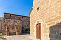
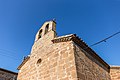
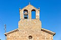
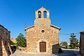
Català: Capella de Sant Pere de Muller, als Plans de Sió (Segarra)
This is a category about a building listed in the Catalan heritage register as Bé Cultural d'Interès Local (BCIL) under the reference IPA-26121. |
| Object location | | View all coordinates using: OpenStreetMap |
|---|
church building in Els Plans de Sió, Spain  | |||||
| Upload media | |||||
| Instance of | |||||
|---|---|---|---|---|---|
| Location | Muller, Els Plans de Sió, Segarra, Ponent, Lleida Province, Catalonia | ||||
| Street address |
| ||||
| Architectural style | |||||
| Heritage designation |
| ||||
| Inception |
| ||||
| Elevation above sea level |
| ||||
 | |||||
Media in category "Sant Pere de Muller"
The following 13 files are in this category, out of 13 total.
-
 Capella de Sant Pere de Muller (els Plans de Sió) - 1.jpg 4,608 × 3,072; 8.74 MB
-
 Capella de Sant Pere de Muller (els Plans de Sió) - 3.jpg 3,072 × 4,286; 7.96 MB
-
 Capella de Sant Pere de Muller (els Plans de Sió) - 4.jpg 4,608 × 3,072; 9.3 MB
-
 Capella de Sant Pere de Muller 1.jpg 5,472 × 3,648; 17.16 MB
-
 Capella de Sant Pere de Muller 2.jpg 5,174 × 3,449; 21.9 MB
-
 Capella de Sant Pere de Muller 3.jpg 5,472 × 3,648; 18.59 MB
-
 Capella de Sant Pere de Muller 4.jpg 5,252 × 3,501; 14.12 MB
-
 Capella de Sant Pere de Muller 5.jpg 5,470 × 3,647; 15.19 MB
-
 Capella de Sant Pere de Muller 6.jpg 5,027 × 3,351; 17.38 MB
-
 Capella de Sant Pere de Muller 7.jpg 4,872 × 3,213; 16.71 MB
-
 Capella de Sant Pere de Muller 8.jpg 4,438 × 2,959; 13.41 MB
-
 Capella de Sant Pere de Muller 9.jpg 5,108 × 3,405; 16.82 MB
-
 Església de Sant Pere de Muller.jpg 558 × 752; 73 KB
_-_1.jpg)
_-_3.jpg)
_-_4.jpg)


