Category:Sarotlahütte
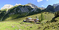
Deutsch: Die Sarotlahütte ist eine alpine Schutzhütte des ÖAV im Rätikon in Vorarlberg. Sie liegt auf 1611 m ü. A. am Ende des Sarotlatals, eines orografisch linken Seitentals des Brandner Tals, nördlich der Zimba.
| Object location | | View all coordinates using: OpenStreetMap |
|---|
building in Vorarlberg, Austria  | |||||
| Upload media | |||||
| Instance of |
| ||||
|---|---|---|---|---|---|
| Location | Vorarlberg, Austria | ||||
| Owned by | |||||
| Inception |
| ||||
| Mountain range | |||||
| Elevation above sea level |
| ||||
 | |||||
Media in category "Sarotlahütte"
The following 11 files are in this category, out of 11 total.
-
 21 Sarotlatal teils schon im Schatten.jpg 2,592 × 1,944; 812 KB
-
 Sarotlaalpe mit Sarotlahütte.jpg 5,962 × 1,981; 9.51 MB
-
 Sarotlaalpe Panorama.jpg 6,534 × 2,113; 12.04 MB
-
 Sarotlahütte 1.JPG 7,360 × 4,912; 21.95 MB
-
 Sarotlahütte 2.jpg 5,604 × 2,835; 14.98 MB
-
 Sarotlahütte 3.jpg 3,244 × 3,238; 8.52 MB
-
 Sarotlahütte Richtung Tschengla.JPG 7,360 × 4,912; 23.19 MB
-
 Sarotlatal Panorama.jpg 6,730 × 2,119; 13.52 MB
-
 Sarotlatal unter Zimba und Brandner Mittagsspitze mit dem Schutzhaus.jpg 3,264 × 2,448; 1.82 MB
-
 Wegweiser bei der Sarotlahütte.JPG 2,977 × 3,969; 4.07 MB
-
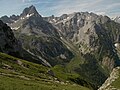
 Zwölferkopf (links), Schafgufel 2351 m (rechts).jpg 3,648 × 2,736; 4.37 MB


,_Schafgufel_2351_m_(rechts).jpg)