Category:Satellite pictures of 2022 Gironde wildfires
Media in category "Satellite pictures of 2022 Gironde wildfires"
The following 16 files are in this category, out of 16 total.
-
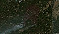 2022-07 Landiras wildfire 01.jpg 2,500 × 1,430; 847 KB
-
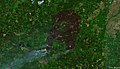
 2022-07 Landiras wildfire 02.jpg 2,500 × 1,430; 915 KB
-
 2022-07 Landiras wildfire 03.jpg 2,500 × 1,430; 1,018 KB
-
 2022-07 Landiras wildfire 04.jpg 2,500 × 1,430; 896 KB
-
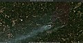
 2022-07-15 - Wildfires in France.jpg 2,409 × 2,085; 568 KB
-
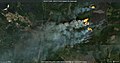
 2022-07-17 Fires in the Teste-de-Buch and Landiras areas 02.jpg 1,152 × 604; 142 KB
-
 2022-07-17 Fires in the Teste-de-Buch and Landiras areas 03.jpg 1,440 × 755; 175 KB
-
 2022-07-17 Fires in the Teste-de-Buch area.jpg 1,440 × 755; 210 KB
-
 A new disastrous wildfire is raging in the southwest of France.jpg 4,397 × 2,537; 3.86 MB
-
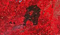
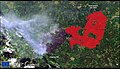
 Burnt area of the wildfires in Gironde and Landes, France.jpg 4,007 × 4,057; 4.61 MB
-
 Major wildfires in western France – La Teste-de-Buch.jpg 4,410 × 2,540; 3.75 MB
-
 Major wildfires in western France – Landiras.jpg 4,410 × 2,540; 4.1 MB
-
 New wildfire burning Gironde, southwestern France.jpg 4,410 × 2,540; 4.43 MB
-
 The Gironde wildfires strongly affected the local fauna.jpg 4,000 × 4,060; 7.19 MB
-
 Wildfires in Gironde ESA24375442.gif 1,920 × 1,920; 6.57 MB
-
 Wildfires in southwest France ESA24375606.gif 1,920 × 1,920; 5.38 MB


