Category:Satellite pictures of Guatemala in 2024
Countries of North America: Guatemala
Subcategories
This category has only the following subcategory.
Media in category "Satellite pictures of Guatemala in 2024"
The following 10 files are in this category, out of 10 total.
-
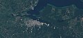
 Amatitlan Lake Guatemala Aerial View - by Sentinel-2.jpg 1,840 × 845; 536 KB
-
 El Golfete Lake - Rio Dulce Guatemala Stellite View.jpg 1,840 × 855; 493 KB
-
 Escuintla Guatemala Aerial View - by Sentinel-2.jpg 1,840 × 845; 365 KB
-
 Flores Petén Guatemala - by Sentinel-2.jpg 1,840 × 845; 308 KB
-
 Guatemala City Aerial View - by Sentinel-2.jpg 1,840 × 845; 635 KB
-
 Huehuetenango Guatemala Aerial View - by Sentinel-2.jpg 1,840 × 845; 601 KB
-
 San Jose Pinula Guatemala Aerial View - by Sentinel-2.jpg 1,840 × 845; 592 KB
-
 San José Escuintla Guatemala - by Sentinel-2.jpg 1,840 × 845; 297 KB
-
 San Juan Sacatepequez Guatemala Aerial View - by Sentinel-2.jpg 1,840 × 845; 535 KB
-
 San Marcos Guatemala Aerial View - by Sentinel-2.jpg 1,840 × 845; 459 KB


