Category:Satellite pictures of Qatar
Countries of Asia: Afghanistan · Armenia‡ · Azerbaijan‡ · Bahrain · Bangladesh · Bhutan · Brunei · Cambodia · People's Republic of China · Cyprus‡ · East Timor · Egypt‡ · Georgia‡ · India · Indonesia‡ · Iran · Iraq · Israel · Japan · Jordan · Kazakhstan‡ · Kuwait · Kyrgyzstan · Laos · Lebanon · Malaysia · Maldives · Mongolia · Myanmar · Nepal · North Korea · Oman · Pakistan · Philippines · Qatar · Russia‡ · Saudi Arabia · Singapore · South Korea · Sri Lanka · Syria · Tajikistan · Thailand · Turkey‡ · Turkmenistan · United Arab Emirates · Uzbekistan · Vietnam · Yemen
Limited recognition: Taiwan · State of Palestine – Other territories: British Indian Ocean Territory · Hong Kong
‡: partly located in Asia
Limited recognition: Taiwan · State of Palestine – Other territories: British Indian Ocean Territory · Hong Kong
‡: partly located in Asia
Subcategories
This category has only the following subcategory.
S
- Satellite pictures of Doha (29 F)
Media in category "Satellite pictures of Qatar"
The following 200 files are in this category, out of 227 total.
(previous page) (next page)-
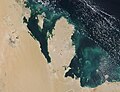
 Al Yasat Marine Protected Area, Qatar & United Arab Emirates (34530992821).jpg 12,636 × 13,047; 28.77 MB
-
 Clear Skies over Qatar (MODIS).jpg 1,718 × 1,311; 258 KB
-
 Doha vue par satellite en 1986.jpg 1,745 × 1,493; 354 KB
-
 Doha vue par satellite en 2022.jpg 1,745 × 1,493; 896 KB
-
 Earth observation (iss068e024291).jpeg 4,928 × 2,768; 4.01 MB
-
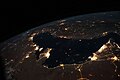 ISS-63 Persian Gulf at night.jpg 5,568 × 3,712; 6.23 MB
-
 ISS002-E-8409 - View of Qatar.jpg 3,060 × 2,092; 1.15 MB
-
 ISS002-E-8410 - View of Qatar.jpg 3,060 × 2,092; 844 KB
-
 ISS002-E-8411 - View of Qatar.jpg 3,060 × 2,092; 802 KB
-
 ISS006-E-16926 - View of Qatar.jpg 3,032 × 2,064; 613 KB
-
 ISS006-E-23634 - View of Qatar.jpg 3,032 × 2,064; 873 KB
-
 ISS006-E-36358 - View of Qatar.jpg 3,032 × 2,064; 1.84 MB
-
 ISS006-E-36359 - View of Qatar.jpg 3,032 × 2,064; 1.8 MB
-
 ISS011-E-10586 - View of Qatar.jpg 3,032 × 2,008; 526 KB
-
 ISS011-E-10587 - View of Qatar.jpg 3,032 × 2,008; 568 KB
-
 ISS011-E-10588 - View of Qatar.jpg 3,032 × 2,008; 691 KB
-
 ISS011-E-10589 - View of Qatar.jpg 3,032 × 2,008; 694 KB
-
 ISS011-E-10590 - View of Qatar.jpg 3,032 × 2,008; 651 KB
-
 ISS011-E-10591 - View of Qatar.jpg 3,032 × 2,008; 774 KB
-
 ISS011-E-10592 - View of Qatar.jpg 3,032 × 2,008; 711 KB
-
 ISS011-E-10593 - View of Qatar.jpg 3,032 × 2,008; 693 KB
-
 ISS011-E-10594 - View of Qatar.jpg 3,032 × 2,008; 716 KB
-
 ISS011-E-10596 - View of Qatar.jpg 3,032 × 2,008; 740 KB
-
 ISS014-E-10511 - View of Qatar.jpg 3,032 × 2,064; 1.18 MB
-
 ISS014-E-10512 - View of Qatar.jpg 3,032 × 2,064; 1.16 MB
-
 ISS014-E-16756 - View of Qatar.jpg 3,032 × 2,064; 776 KB
-
 ISS014-E-16757 - View of Qatar.jpg 3,032 × 2,064; 810 KB
-
 ISS014-E-16758 - View of Qatar.jpg 3,032 × 2,064; 1,018 KB
-
 ISS015-E-26880 - View of Qatar.jpg 3,032 × 2,008; 939 KB
-
 ISS015-E-26881 - View of Qatar.jpg 3,032 × 2,008; 895 KB
-
 ISS016-E-21740 - View of Qatar.jpg 3,032 × 2,008; 997 KB
-
 ISS016-E-21741 - View of Qatar.jpg 3,032 × 2,008; 797 KB
-
 ISS016-E-21742 - View of Qatar.jpg 3,032 × 2,008; 823 KB
-
 ISS020-E-20817 - View of Qatar.jpg 4,288 × 2,848; 1.2 MB
-
 ISS020-E-20818 - View of Qatar.jpg 4,288 × 2,848; 1.32 MB
-
 ISS020-E-20819 - View of Qatar.jpg 4,288 × 2,848; 1.09 MB
-
 ISS020-E-20820 - View of Qatar.jpg 4,288 × 2,848; 1.06 MB
-
 ISS020-E-20821 - View of Qatar.jpg 4,288 × 2,848; 985 KB
-
 ISS020-E-20822 - View of Qatar.jpg 4,288 × 2,848; 1,005 KB
-
 ISS020-E-20823 - View of Qatar.jpg 4,288 × 2,848; 1.06 MB
-
 ISS020-E-20824 - View of Qatar.jpg 4,288 × 2,848; 1.1 MB
-
 ISS020-E-20825 - View of Qatar.jpg 4,288 × 2,848; 1.07 MB
-
 ISS020-E-20826 - View of Qatar.jpg 4,288 × 2,848; 1.06 MB
-
 ISS020-E-20827 - View of Qatar.jpg 4,288 × 2,848; 1.11 MB
-
 ISS020-E-20828 - View of Qatar.jpg 4,288 × 2,848; 1.14 MB
-
 ISS020-E-20829 - View of Qatar.jpg 4,288 × 2,848; 1.18 MB
-
 ISS020-E-20830 - View of Qatar.jpg 4,288 × 2,848; 1.25 MB
-
 ISS020-E-20831 - View of Qatar.jpg 4,288 × 2,848; 1.08 MB
-
 ISS020-E-20832 - View of Qatar.jpg 4,288 × 2,848; 976 KB
-
 ISS020-E-20833 - View of Qatar.jpg 4,288 × 2,848; 977 KB
-
 ISS020-E-20834 - View of Qatar.jpg 4,288 × 2,848; 1.12 MB
-
 ISS020-E-20835 - View of Qatar.jpg 4,288 × 2,848; 1.3 MB
-
 ISS020-E-20836 - View of Qatar.jpg 4,288 × 2,848; 1.02 MB
-
 ISS020-E-20837 - View of Qatar.jpg 4,288 × 2,848; 1.22 MB
-
 ISS020-E-20838 - View of Qatar.jpg 4,288 × 2,848; 978 KB
-
 ISS020-E-20839 - View of Qatar.jpg 4,288 × 2,848; 1.06 MB
-
 ISS020-E-20840 - View of Qatar.jpg 4,288 × 2,848; 1.12 MB
-
 ISS020-E-20842 - View of Qatar.jpg 4,288 × 2,848; 892 KB
-
 ISS020-E-20843 - View of Qatar.jpg 4,288 × 2,848; 1.07 MB
-
 ISS020-E-20844 - View of Qatar.jpg 4,288 × 2,848; 1.12 MB
-
 ISS020-E-20845 - View of Qatar.jpg 4,288 × 2,848; 1.13 MB
-
 ISS020-E-20846 - View of Qatar.jpg 4,288 × 2,848; 1.09 MB
-
 ISS020-E-20847 - View of Qatar.jpg 4,288 × 2,848; 1.09 MB
-
 ISS020-E-20848 - View of Qatar.jpg 4,288 × 2,848; 1.03 MB
-
 ISS020-E-20849 - View of Qatar.jpg 4,288 × 2,848; 1.03 MB
-
 ISS020-E-21077 - View of Qatar.jpg 4,256 × 2,832; 926 KB
-
 ISS020-E-21078 - View of Qatar.jpg 4,256 × 2,832; 867 KB
-
 ISS020-E-21079 - View of Qatar.jpg 4,256 × 2,832; 769 KB
-
 ISS020-E-21080 - View of Qatar.jpg 4,256 × 2,832; 886 KB
-
 ISS020-E-21082 - View of Qatar.jpg 4,256 × 2,832; 1.04 MB
-
 ISS020-E-21083 - View of Qatar.jpg 4,256 × 2,832; 817 KB
-
 ISS020-E-21084 - View of Qatar.jpg 4,256 × 2,832; 679 KB
-
 ISS020-E-28718 - View of Qatar.jpg 4,288 × 2,848; 647 KB
-
 ISS020-E-28719 - View of Qatar.jpg 4,288 × 2,848; 679 KB
-
 ISS020-E-28720 - View of Qatar.jpg 4,288 × 2,848; 802 KB
-
 ISS020-E-32613 - View of Qatar.jpg 4,288 × 2,848; 1.05 MB
-
 ISS020-E-32614 - View of Qatar.jpg 4,288 × 2,848; 1.07 MB
-
 ISS020-E-32615 - View of Qatar.jpg 4,288 × 2,848; 1,015 KB
-
 ISS020-E-6971 - View of Qatar.jpg 4,256 × 2,832; 632 KB
-
 ISS020-E-6972 - View of Qatar.jpg 4,256 × 2,832; 812 KB
-
 ISS020-E-6973 - View of Qatar.jpg 4,256 × 2,832; 702 KB
-
 ISS020-E-6974 - View of Qatar.jpg 4,256 × 2,832; 640 KB
-
 ISS020-E-6975 - View of Qatar.jpg 4,256 × 2,832; 778 KB
-
 ISS021-E-8427 - View of Qatar.jpg 3,072 × 2,040; 550 KB
-
 ISS022-E-100005 - View of Qatar.jpg 4,288 × 2,848; 1.42 MB
-
 ISS022-E-101571 - View of Qatar.jpg 6,048 × 4,147; 2.49 MB
-
 ISS023-E-16130 - View of Qatar.jpg 4,288 × 2,848; 829 KB
-
 ISS023-E-16131 - View of Qatar.jpg 4,288 × 2,848; 898 KB
-
 ISS023-E-16132 - View of Qatar.jpg 4,288 × 2,848; 788 KB
-
 ISS023-E-16133 - View of Qatar.jpg 4,288 × 2,848; 1.01 MB
-
 ISS023-E-16134 - View of Qatar.jpg 4,288 × 2,848; 1.17 MB
-
 ISS023-E-16135 - View of Qatar.jpg 4,288 × 2,848; 853 KB
-
 ISS023-E-16136 - View of Qatar.jpg 4,288 × 2,848; 1.14 MB
-
 ISS023-E-16137 - View of Qatar.jpg 4,288 × 2,848; 1 MB
-
 ISS023-E-16138 - View of Qatar.jpg 4,288 × 2,848; 928 KB
-
 ISS023-E-16139 - View of Qatar.jpg 4,288 × 2,848; 856 KB
-
 ISS023-E-16140 - View of Qatar.jpg 4,288 × 2,848; 993 KB
-
 ISS023-E-16141 - View of Qatar.jpg 4,288 × 2,848; 974 KB
-
 ISS023-E-16142 - View of Qatar.jpg 4,288 × 2,848; 880 KB
-
 ISS023-E-16143 - View of Qatar.jpg 4,288 × 2,848; 786 KB
-
 ISS023-E-17546 - View of Qatar.jpg 4,288 × 2,848; 812 KB
-
 ISS023-E-17547 - View of Qatar.jpg 4,288 × 2,848; 863 KB
-
 ISS023-E-17548 - View of Qatar.jpg 4,288 × 2,848; 899 KB
-
 ISS023-E-17549 - View of Qatar.jpg 4,288 × 2,848; 828 KB
-
 ISS023-E-17550 - View of Qatar.jpg 4,288 × 2,848; 947 KB
-
 ISS023-E-17551 - View of Qatar.jpg 4,288 × 2,848; 902 KB
-
 ISS023-E-17552 - View of Qatar.jpg 4,288 × 2,848; 847 KB
-
 ISS023-E-17553 - View of Qatar.jpg 4,288 × 2,848; 815 KB
-
 ISS023-E-17554 - View of Qatar.jpg 4,288 × 2,848; 754 KB
-
 ISS023-E-18227 - View of Qatar.jpg 4,288 × 2,848; 815 KB
-
 ISS023-E-18228 - View of Qatar.jpg 4,288 × 2,848; 994 KB
-
 ISS023-E-18229 - View of Qatar.jpg 4,288 × 2,848; 1.03 MB
-
 ISS023-E-18230 - View of Qatar.jpg 4,288 × 2,848; 877 KB
-
 ISS023-E-18231 - View of Qatar.jpg 4,288 × 2,848; 828 KB
-
 ISS023-E-18232 - View of Qatar.jpg 4,288 × 2,848; 847 KB
-
 ISS023-E-18233 - View of Qatar.jpg 4,288 × 2,848; 850 KB
-
 ISS023-E-18234 - View of Qatar.jpg 4,288 × 2,848; 1.09 MB
-
 ISS023-E-18235 - View of Qatar.jpg 4,288 × 2,848; 1.38 MB
-
 ISS023-E-18236 - View of Qatar.jpg 4,288 × 2,848; 1.21 MB
-
 ISS023-E-18237 - View of Qatar.jpg 4,288 × 2,848; 1.21 MB
-
 ISS023-E-18238 - View of Qatar.jpg 4,288 × 2,848; 888 KB
-
 ISS023-E-18239 - View of Qatar.jpg 4,288 × 2,848; 820 KB
-
 ISS023-E-18240 - View of Qatar.jpg 4,288 × 2,848; 1.4 MB
-
 ISS023-E-18241 - View of Qatar.jpg 4,288 × 2,848; 1.64 MB
-
 ISS023-E-18242 - View of Qatar.jpg 4,288 × 2,848; 1.48 MB
-
 ISS023-E-18243 - View of Qatar.jpg 4,288 × 2,848; 779 KB
-
 ISS023-E-33572 - View of Qatar.jpg 4,256 × 2,913; 787 KB
-
 ISS023-E-33575 - View of Qatar.jpg 4,256 × 2,913; 683 KB
-
 ISS023-E-33576 - View of Qatar.jpg 4,256 × 2,913; 606 KB
-
 ISS023-E-33577 - View of Qatar.jpg 4,256 × 2,913; 602 KB
-
 ISS023-E-33583 - View of Qatar.jpg 4,256 × 2,913; 646 KB
-
 ISS023-E-33584 - View of Qatar.jpg 4,256 × 2,913; 786 KB
-
 ISS023-E-33585 - View of Qatar.jpg 4,256 × 2,913; 835 KB
-
 ISS023-E-33586 - View of Qatar.jpg 4,256 × 2,913; 862 KB
-
 ISS023-E-33587 - View of Qatar.jpg 4,256 × 2,913; 894 KB
-
 ISS023-E-33588 - View of Qatar.jpg 4,256 × 2,913; 826 KB
-
 ISS023-E-41953 - View of Qatar.jpg 4,256 × 2,913; 1.02 MB
-
 ISS023-E-6732 - View of Halul Island, Qatar (cropped).jpg 1,200 × 1,200; 157 KB
-
 ISS023-E-6732 - View of Qatar.jpg 4,288 × 2,848; 597 KB
-
 ISS025-E-6120 - View of Qatar (al khor).jpg 452 × 420; 64 KB
-
 ISS025-E-6120 - View of Qatar.jpg 4,288 × 2,929; 1.2 MB
-
 ISS025-E-6121 - View of Qatar.jpg 4,288 × 2,929; 1.54 MB
-
 ISS026-E-9169 - View of Qatar.jpg 4,256 × 2,913; 940 KB
-
 ISS026-E-9170 - View of Qatar.jpg 4,256 × 2,913; 956 KB
-
 ISS026-E-9181 - View of Qatar.jpg 4,256 × 2,913; 1.17 MB
-
 ISS026-E-9182 - View of Qatar.jpg 4,256 × 2,913; 1.23 MB
-
 ISS026-E-9183 - View of Qatar.jpg 4,256 × 2,913; 1.19 MB
-
 ISS026-E-9184 - View of Qatar.jpg 4,256 × 2,913; 1.24 MB
-
 ISS032-E-24695 - View of Qatar.jpg 4,288 × 2,848; 1.1 MB
-
 ISS032-E-24696 - View of Qatar.jpg 4,288 × 2,848; 1.09 MB
-
 ISS033-E-14856 - View of Qatar.jpg 1,440 × 958; 417 KB
-
 ISS035-E-7358 - View of Qatar.jpg 4,256 × 2,832; 766 KB
-
 ISS035-E-7359 - View of Qatar.jpg 4,256 × 2,832; 752 KB
-
 ISS035-E-7360 - View of Qatar.jpg 4,256 × 2,832; 794 KB
-
 ISS035-E-7362 - View of Qatar.jpg 4,256 × 2,832; 811 KB
-
 ISS035-E-7363 - View of Qatar.jpg 4,256 × 2,832; 795 KB
-
 ISS036-E-11058 - View of Qatar.jpg 4,256 × 2,832; 864 KB
-
 ISS036-E-16248 - View of Qatar.jpg 4,256 × 2,832; 864 KB
-
 ISS036-E-16251 - View of Qatar.jpg 4,256 × 2,832; 949 KB
-
 ISS036-E-2717 - View of Qatar.jpg 4,256 × 2,832; 614 KB
-
 ISS038-E-68619 - View of Qatar.jpg 6,048 × 4,032; 2.4 MB
-
 ISS038-E-68620 - View of Qatar.jpg 6,048 × 4,032; 2.84 MB
-
 ISS038-E-68621 - View of Qatar.jpg 6,048 × 4,032; 2.9 MB
-
 ISS053-E-127285 - View of Qatar.jpg 4,928 × 3,280; 763 KB
-
 ISS053-E-127286 - View of Qatar.jpg 4,928 × 3,280; 785 KB
-
 ISS053-E-127297 - View of Qatar.jpg 4,928 × 3,280; 781 KB
-
 ISS053-E-127298 - View of Qatar.jpg 4,928 × 3,280; 795 KB
-
 ISS055-E-10085 - View of Qatar.jpg 5,568 × 3,712; 1.22 MB
-
 ISS058-E-26356 - View of Qatar.jpg 5,568 × 3,712; 1.67 MB
-
 ISS061-E-66584 - View of Qatar.jpg 5,568 × 3,712; 7.32 MB
-
 ISS062-E-46302 - View of Qatar.jpg 5,568 × 3,712; 1.29 MB
-
 ISS062-E-46303 - View of Qatar.jpg 5,568 × 3,712; 1.3 MB
-
 ISS062-E-46304 - View of Qatar.jpg 5,568 × 3,712; 1.33 MB
-
 ISS062-E-46305 - View of Qatar.jpg 5,568 × 3,712; 1.31 MB
-
 ISS062-E-46306 - View of Qatar.jpg 5,568 × 3,712; 1.28 MB
-
 ISS062-E-46307 - View of Qatar.jpg 5,568 × 3,712; 1.34 MB
-
 ISS062-E-46308 - View of Qatar.jpg 5,568 × 3,712; 1.35 MB
-
 ISS062-E-46338 - View of Earth.jpg 5,568 × 3,712; 1.45 MB
-
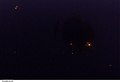
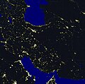 Night lights of Iran.jpg 5,630 × 5,580; 2.06 MB
-
 Northern Qatari Peninsula satellite imagery in 2008.jpg 3,032 × 2,064; 785 KB
-
 Satellite image of Qatar in January 2003.jpg 383 × 790; 34 KB
-
 Satellite imagery of Al Khor 2009.jpg 4,288 × 2,929; 715 KB
-
 Satellite imagery of Al Rayyan urban area.jpg 4,288 × 2,929; 878 KB
-
 Satellite imagery of Al Wukair in 2010.jpg 595 × 518; 70 KB
-
 Satellite imagery of Al-Shahaniya City in 2010 (cropped).jpg 1,178 × 805; 1.02 MB
-
 Satellite imagery of Al-Shahaniya City in 2010.jpg 4,288 × 2,929; 859 KB
-
 Satellite imagery of Doha and Al Wakrah in 2009 (cropped) 2.jpg 396 × 278; 39 KB
-
 Satellite imagery of Dukhan in 2008.jpg 423 × 336; 27 KB
-
 Satellite imagery of Mesaieed in 2010 (cropped).jpg 959 × 624; 163 KB
-
 Satellite imagery of Mesaieed in 2010.jpg 4,288 × 2,929; 1.2 MB
-
 Satellite imagery of Mesaieed Industrial Area in 2010.jpg 1,190 × 570; 161 KB
-
 Satellite imagery of Mesaieed taken in 2010.jpg 4,256 × 2,913; 723 KB
-
 Satellite imagery of northern Qatar in 2014.jpg 4,928 × 3,280; 1.4 MB
-
 Satellite imagery of northern Qatari Peninsula 2007 (cropped).jpg 1,897 × 1,577; 854 KB
-
 Satellite imagery of northern Qatari Peninsula 2007.jpg 3,032 × 2,064; 1.69 MB
-
 Satellite imagery of Ras Laffan 2007.jpg 718 × 489; 98 KB
-
 Satellite imagery of Ras Rakan 2007.jpg 522 × 356; 54 KB
-
 Satellite imagery of southern Qatari Peninsula Saudi Arabia Gulf of Salwa.jpg 4,288 × 2,848; 818 KB
-
 Satellite imagery of western Qatar.jpg 3,032 × 2,064; 989 KB
-
 Satellite view of Al Rayyan and Al Shahaniya in 2013.jpg 4,256 × 2,832; 597 KB
.jpg)


.jpeg)


.jpg)

.jpg)


.jpg)

_2.jpg)

.jpg)


.jpg)


.jpg)