Category:Sawtooth Range
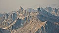
mountain range in the US state of Idaho   | |||||
| Upload media | |||||
| Instance of | |||||
|---|---|---|---|---|---|
| Location | Idaho | ||||
| Width |
| ||||
| Length |
| ||||
| Mountain range | |||||
| Highest point |
| ||||
| Area |
| ||||
| Elevation above sea level |
| ||||
| official website | |||||
 | |||||
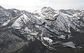
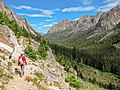
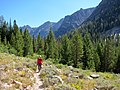
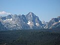
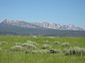
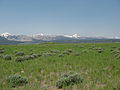
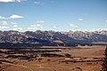
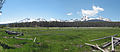
- The Sawtooth Range — a mountain range of the Rocky Mountains in Idaho.
Subcategories
This category has the following 11 subcategories, out of 11 total.
A
- Alpine Lake, Idaho (7 F)
D
- Diamond Lake (Idaho) (2 F)
H
- Hell Roaring Lake (8 F)
L
- Lily Lake (Idaho) (17 F)
- Little Redfish Lake (15 F)
R
- Redfish Lake (1 P, 39 F)
S
- Sawtooth Lake (4 F)
- Stanley Lake (14 F)
Media in category "Sawtooth Range"
The following 200 files are in this category, out of 234 total.
(previous page) (next page)-
 057-West Side Sawtooths.jpg 800 × 600; 97 KB
-
 059-Sawtooths and Salmon Headwaters.jpg 1,027 × 300; 58 KB
-
 Above Pettit Lake.jpg 1,500 × 1,000; 349 KB
-
Alice Lake Sawtooth.webm 24 s, 1,077 × 606; 6.77 MB
-
 Alice Lake.jpg 3,648 × 2,736; 4.61 MB
-
 Alpine Lake (15162205026).jpg 3,000 × 4,000; 2.49 MB
-
 Alpine Lake (15182202991).jpg 4,000 × 3,000; 1.88 MB
-
 Alpine Lake (15184863062).jpg 4,000 × 3,000; 2.01 MB
-
 Alpine Lake (15185233895).jpg 3,000 × 4,000; 2.76 MB
-
 Alpine Lake in Iron Creek watershed.JPG 2,816 × 2,112; 4.61 MB
-
 Alpine Lake in Sawtooth Wilderness.jpg 3,648 × 2,736; 3.63 MB
-
 Alpine Meadow (15184851642).jpg 4,000 × 3,000; 3.28 MB
-
 Alpine Peak (15182208061).jpg 4,000 × 3,000; 1.94 MB
-
 Alpine Way Trial south of Marshall Lake.JPG 2,816 × 2,112; 3.29 MB
-
 An unnamed lake and Williams Peak from Thompson Peak - panoramio.jpg 1,451 × 1,600; 309 KB
-
 Baron Lake Idaho.jpg 1,024 × 768; 563 KB
-
 Baron Lakes Idaho.jpg 768 × 1,024; 574 KB
-
 Baron Spire.jpg 2,025 × 2,365; 2.88 MB
-
 Behind Stanley Lake 3.JPG 1,600 × 1,200; 393 KB
-
 Bench Lake puddle and Mount Heyburn.jpg 1,500 × 1,072; 2.11 MB
-
 Braxon Peak.jpg 1,407 × 1,169; 506 KB
-
 Cabin with Sawtooths backdrop.jpg 1,000 × 670; 626 KB
-
 Camping in Stanley ID.jpg 1,600 × 1,200; 160 KB
-
 Cirque Lake Peak.jpg 2,577 × 2,092; 1.11 MB
-
 Clouds over Sawtooths.jpg 1,600 × 1,200; 92 KB
-
 Cramer Lakes basin from Alpine Lake trail in Sawtooth Wilderness.jpg 3,648 × 2,736; 4.08 MB
-
 Decker Peak.jpg 1,646 × 1,513; 1.25 MB
-
 Dramatic clouds pre sunrise at Hell Roaring Lake.jpg 1,795 × 1,201; 1.49 MB
-
 Dramatic morning clouds over Hell Roaring Lake Sawtooth Mountains.jpg 1,352 × 1,336; 1.22 MB
-
 Driving through the Sawtooth Mountains.jpg 1,024 × 685; 317 KB
-
 Edna Lake.JPG 2,816 × 2,112; 3.6 MB
-
 El Capitan and Alice Lake.jpg 1,500 × 1,000; 420 KB
-
 El Capitan ID.JPG 2,736 × 3,648; 4.97 MB
-
 Elk Peak (Idaho).jpg 2,025 × 1,256; 497 KB
-
 Falls Creek Valley.JPG 1,600 × 1,200; 374 KB
-
 Farley Lake Sawtooth NRA.jpg 1,187 × 800; 693 KB
-
 Finger of Fate (Idaho).jpg 1,024 × 1,209; 852 KB
-
 Galena Overlook.jpg 3,300 × 2,106; 3.91 MB
-
 Galena Summit Memorial Day 2012.jpg 5,184 × 3,456; 11.14 MB
-
 FEDLINK - United States Federal Collection (IA geology10510700fern).pdf 1,229 × 1,604, 310 pages; 8.56 MB
-
 Goat Lake - panoramio.jpg 4,160 × 2,547; 5.8 MB
-
Goat Lake Sawtooth.webm 34 s, 1,077 × 606; 8.78 MB
-
 Goat Lake.jpg 3,648 × 2,736; 4.87 MB
-
 God Rays Galena Summit Idaho.jpg 1,500 × 1,004; 1.28 MB
-
 Grand Mogul 3.JPG 2,816 × 2,112; 1.93 MB
-
 Grand Mogul from Redfish Lake Creek trail.jpg 3,648 × 2,736; 3.94 MB
-
 Grand Mogul through the clouds.JPG 1,600 × 1,200; 330 KB
-
 Grand Mogul.JPG 2,816 × 2,112; 1.71 MB
-
 Grand Mogul2.JPG 3,296 × 2,472; 1.83 MB
-
 Grandjean Peak.jpg 2,304 × 1,272; 2.05 MB
-
 Gunfighter's flagship over Idaho.JPG 4,099 × 2,586; 5.95 MB
-
 Gunfighter's flagship over Idaho2.JPG 4,256 × 2,832; 5.14 MB
-
 High in the Sawtooths.jpg 1,024 × 768; 660 KB
-
 Hiker and Redfish Canyon from Alpine Lake trail in Sawtooth Wilderness.jpg 3,648 × 2,736; 3.7 MB
-
 Hiker on Alpine Lake trail in Sawtooth Wilderness.jpg 3,648 × 2,736; 3.94 MB
-
 Hiking in the White Cloud Peaks of central Idaho.jpg 2,863 × 2,040; 6.35 MB
-
 Hiking Through Sawtooth.jpg 1,024 × 685; 340 KB
-
 Hiking to Fourth of July Lake, White Cloud Peaks ID.jpg 2,851 × 2,045; 6.88 MB
-
 Horstmann Peak.jpg 2,816 × 2,112; 3.24 MB
-
 Idaho - Sawtooth Range - NARA - 23939479.jpg 4,367 × 3,388; 2.92 MB
-
 Idaho - Sawtooth Range - NARA - 23939481.jpg 4,367 × 3,388; 1.89 MB
-
 Idaho - Sawtooth Range - NARA - 23939483.jpg 4,367 × 3,388; 2.94 MB
-
 Idaho - Sawtooth Range - NARA - 23939485.jpg 4,367 × 3,388; 3.11 MB
-
 Idaho - Sawtooth Range - NARA - 23939487.jpg 4,367 × 3,388; 1.96 MB
-
 Idaho - Sawtooth Range - NARA - 23939489.jpg 4,367 × 3,388; 3.12 MB
-
 Idaho - Sawtooth Range - NARA - 23939491.jpg 4,367 × 3,388; 3.5 MB
-
 Idaho - Sawtooth Range - NARA - 23939493.jpg 4,367 × 3,388; 3.18 MB
-
 Idaho - Sawtooth Range - NARA - 23939495.jpg 4,367 × 3,388; 3.47 MB
-
 Idaho - Sawtooth Range - NARA - 23939497.jpg 4,367 × 3,388; 3.62 MB
-
 Idaho - Sawtooth Range - NARA - 23939499.jpg 4,367 × 3,388; 3.25 MB
-
 Idaho - Sawtooth Range - NARA - 23939501.jpg 4,367 × 3,388; 3.1 MB
-
 Idaho - Sawtooth Range - NARA - 23939503.jpg 4,367 × 3,388; 2.74 MB
-
 Idaho - Sawtooth Range - NARA - 23939505.jpg 4,367 × 3,388; 3.06 MB
-
 Idaho - Sawtooth Range - NARA - 23939507.jpg 4,367 × 3,388; 3.01 MB
-
 Idaho 75 Sawtooth Valley Winter.jpg 1,024 × 768; 335 KB
-
 Idaho Sawtooths.jpg 1,600 × 1,200; 684 KB
-
 IDAHO-B-0008 Salmon River - Lower Stanley.jpg 1,601 × 1,030; 238 KB
-
 IDAHO-J-0085 Sheep - Stanley Basin.jpg 2,385 × 1,849; 635 KB
-
 IDSawtoothRoadsign.jpg 428 × 197; 23 KB
-
 Iron Creek Sawtooth NRA.JPG 3,648 × 2,736; 5.54 MB
-
 Lonely Road, Idaho State Highway 75.jpg 5,724 × 3,545; 12.67 MB
-
 Looking down on Fourth of July Lake and the distant Sawtooths.jpg 3,134 × 2,086; 3.65 MB
-
 Looking northwest towards the Sawtooths and Stanley Basin ID.jpg 3,154 × 2,100; 3.27 MB
-
 McDonald Lake.jpg 2,816 × 2,112; 3.06 MB
-
 McDonald Peak ID.jpg 1,425 × 1,188; 723 KB
-
 Merritt Peak, Idaho.jpg 2,733 × 1,453; 1.74 MB
-
 Merritt Peak.jpg 2,806 × 2,471; 3.32 MB
-
 Mickey's Spire.JPG 2,736 × 3,648; 4.98 MB
-
 Mount Carter ID.JPG 3,648 × 2,736; 4.94 MB
-
 Mount Heyburn (14871893427).jpg 4,000 × 3,000; 2.4 MB
-
 Mount Heyburn (15058435825).jpg 2,590 × 3,453; 2.1 MB
-
 Mount Heyburn Autumn.jpg 1,000 × 670; 860 KB
-
 Mount Regan with a glimpse of Sawtooth Lake.jpg 1,176 × 1,171; 617 KB
-
 Mountains behind Stanley, Idaho with a car hauling tail kicking up dust.jpg 3,504 × 2,336; 858 KB
-
 Mt Heyborn Morning Sun.jpg 1,000 × 669; 819 KB
-
 Mystery Mountain (Idaho).jpg 1,770 × 983; 903 KB
-
 Open+Sawtooths.jpg 1,024 × 768; 245 KB
-
 Packrat Peak.jpg 2,255 × 1,416; 644 KB
-
 Paddling Alturas.jpg 640 × 480; 166 KB
-
 Parks Peak.JPG 2,816 × 2,112; 2.14 MB
-
 Pettit Lake.jpg 3,648 × 2,736; 3.45 MB
-
 Pond Below Alice Lake.jpg 1,500 × 1,000; 520 KB
-
 Purple Mountain Majesty.jpg 1,280 × 719; 380 KB
-
 Rain over Sawtooths.jpg 1,600 × 1,200; 122 KB
-
 Rakers.jpg 2,957 × 2,011; 866 KB
-
 Redfish Canyon from Alpine Lake trail in Sawtooth Wilderness.jpg 3,648 × 2,736; 3.72 MB
-
 Rendezvous Lake and South Fork Payette River.jpg 2,816 × 2,112; 3.93 MB
-
 Roadside Pasture South of Stanley.jpg 1,280 × 960; 542 KB
-
 S Sawtooth Valley.JPG 1,600 × 1,200; 379 KB
-
 Saddleback Lake 2, Sawtooth Wilderness, Idaho, USA.jpg 960 × 720; 175 KB
-
 Salmon Cabin and Sawtooths.jpg 1,000 × 669; 667 KB
-
 Salmon River near Lower Stanley, Idaho (15206299986).jpg 4,000 × 3,000; 1.82 MB
-
 Salmon River Valley from Galena Overlook 2.jpg 960 × 1,280; 576 KB
-
 Salmon River Valley from Galena Overlook.jpg 1,280 × 960; 604 KB
-
 Sawtooth aerial.jpg 4,288 × 2,848; 4.28 MB
-
 Sawtooth aerial2.jpg 2,848 × 4,288; 3.51 MB
-
 Sawtooth Afternoon.jpg 1,600 × 1,200; 187 KB
-
 Sawtooth Autumn Rain.jpg 1,500 × 1,000; 1.57 MB
-
 Sawtooth From Alpine Way Trail.JPG 2,816 × 2,112; 3.56 MB
-
 Sawtooth from South 2.JPG 2,816 × 2,112; 1.71 MB
-
 Sawtooth from Stanley Lake Creek.JPG 2,816 × 2,112; 3.54 MB
-
 Sawtooth from west of Stanley.jpg 1,600 × 1,200; 200 KB
-
 Sawtooth Lake Trail (15184867522).jpg 4,000 × 3,000; 2.53 MB
-
 Sawtooth Mountain Range.jpg 1,920 × 1,280; 656 KB
-
 Sawtooth Mountains (9358725477).jpg 2,160 × 1,440; 2.64 MB
-
 Sawtooth Mountains 2008 - panoramio.jpg 8,793 × 1,619; 3.04 MB
-
 Sawtooth Mountains and Salmon River.JPG 2,816 × 2,112; 3.34 MB
-
 Sawtooth mountains below galena.jpg 1,024 × 681; 448 KB
-
 Sawtooth mountains fishhook creek.jpg 2,558 × 1,915; 1.96 MB
-
 Sawtooth Mountains June 2008 - panoramio.jpg 3,822 × 1,830; 1.4 MB
-
 Sawtooth Mountains old.jpg 1,779 × 602; 270 KB
-

-

-
 Sawtooth Mountains.JPG 2,816 × 2,112; 1.17 MB
-
 Sawtooth Mountains1.JPG 2,048 × 1,536; 830 KB
-
 Sawtooth mtns.JPG 2,816 × 2,112; 3.3 MB
-
 Sawtooth Panorama - panoramio.jpg 10,052 × 1,414; 2.26 MB
-
 Sawtooth Panorama 1.JPG 11,889 × 1,683; 15.45 MB
-
 Sawtooth Panorama 2.jpg 9,973 × 1,974; 12.72 MB
-
 Sawtooth Peak SW from Thompson Peak.JPG 2,213 × 1,518; 927 KB
-
 Sawtooth Range (14998438159).jpg 3,526 × 2,644; 1.02 MB
-
 Sawtooth Range ID1.jpg 3,872 × 1,976; 4.63 MB
-
 Sawtooth Range, Idaho 2015.jpg 5,760 × 3,246; 10.34 MB
-
 Sawtooth Range, Idaho magnitude 2.9 earthquake (4-13 AM, 8 July 2020).jpg 1,500 × 914; 1.61 MB
-
 Sawtooth Range-Idaho.jpg 640 × 427; 123 KB
-
 Sawtooth Range-Idaho2.jpg 640 × 427; 96 KB
-
 Sawtooth Range.JPG 2,816 × 2,112; 3.32 MB
-
 Sawtooth Valley - panoramio.jpg 5,033 × 1,851; 1.7 MB
-
 Sawtooth Valley 1.jpg 10,756 × 1,689; 3.57 MB
-
 Sawtooth Valley 2008 - panoramio.jpg 9,166 × 1,704; 3.12 MB
-
 Sawtooth Valley ID1.jpg 3,778 × 2,241; 7.44 MB
-
 Sawtooth Valley.JPG 2,816 × 2,112; 1.37 MB
-
 Sawtooth Valley2.jpg 1,024 × 395; 244 KB
-
 Sawtooth Wilderness Baron Lakes 2008.JPG 3,072 × 2,304; 2.43 MB
-
 Sawtooth Wilderness Ridge (14998474399).jpg 4,000 × 3,000; 2.58 MB
-
 Sawtooth Wilderness Ridge (14998646938).jpg 4,000 × 3,000; 3.05 MB
-
 Sawtooth Wilderness Ridge (15030367097).jpg 4,000 × 3,000; 2.44 MB
-
 Sawtooth Wilderness Ridge (15184853062).jpg 4,000 × 3,000; 2.69 MB
-
 Sawtooth Wilderness Ridge (15184865932).jpg 4,000 × 3,000; 1.91 MB
-
 Sawtooth Wilderness Smoke.jpg 640 × 426; 176 KB
-
 Sawtooth Wilderness Summit Lake NorthRaker.JPG 3,072 × 2,304; 2.71 MB
-
 SawtoothRange - zoomed out.jpg 2,048 × 1,536; 721 KB
-
 Sawtooths 2010.jpg 1,600 × 1,200; 141 KB
-
 Sawtooths 4.jpg 4,871 × 1,605; 1.75 MB
-
 Sawtooths along highway.jpg 1,024 × 681; 494 KB
-
 Sawtooths and Fence2.jpg 2,643 × 1,869; 625 KB
-
 Sawtooths and S Fork of Payette.JPG 2,816 × 2,112; 3.75 MB
-
 Sawtooths and Toxaway Lake.JPG 2,816 × 2,112; 3.53 MB
-
 Sawtooths from Alpine Way Trail - panoramio.jpg 4,127 × 1,857; 5.72 MB
-
 Sawtooths from east 2.jpg 1,600 × 1,200; 177 KB
-
 Sawtooths from South 3.JPG 2,816 × 2,112; 1.21 MB
-
 Sawtooths from South 4.JPG 2,816 × 2,112; 1.27 MB
-
 Sawtooths from South.JPG 2,816 × 2,112; 1.8 MB
-
 Sawtooths from Stanley.jpg 1,024 × 768; 309 KB
-
 Sawtooths from west.jpg 640 × 480; 81 KB
-
 Sawtooths galena.jpg 1,024 × 681; 410 KB
-
 Sawtooths in wildfire smoke.jpg 4,288 × 2,848; 3.29 MB
-
 Sawtooths in winter.jpg 1,024 × 768; 365 KB
-
 Sawtooths Memorial Day 2012.jpg 5,184 × 3,456; 9.89 MB
-
 Sawtooths new.jpg 1,600 × 1,200; 127 KB
-
 Sawtooths North 1.jpg 4,411 × 1,920; 6.11 MB
-
 Sawtooths South 3.jpg 5,009 × 1,880; 6.98 MB
-
 Sawtooths via Galena.jpg 1,024 × 474; 207 KB
-
 Sawtooths.JPG 2,816 × 2,112; 3.95 MB
-
 Sawtooths2.JPG 2,816 × 2,112; 3.35 MB
-
 Sevy Peak.jpg 1,351 × 1,438; 1.4 MB
-
 SF Payette Valley.JPG 1,600 × 1,200; 386 KB
-
 Small Lake Near Sawtooth Lake.JPG 2,112 × 2,816; 2.02 MB
-
 Smith Falls.JPG 1,200 × 1,600; 349 KB
-
 Smoky Sawtooth NF.jpg 4,288 × 2,848; 1.68 MB
-
 Smoky Sawtooths.jpg 4,288 × 2,848; 3.23 MB
-
 SNRA Becca Ranch-for-Sale DSCN8997 sm (10203411505).jpg 1,600 × 1,200; 1.64 MB
-
 Southern Sawtooths.JPG 2,816 × 2,112; 1.56 MB
-
 Spring Sawtooths.jpg 1,024 × 768; 353 KB
-
 Stanley ID camping.jpg 1,600 × 1,200; 110 KB
-
 Stanley Lake and McGowan.jpg 1,178 × 1,074; 675 KB
-
 The Rakers, aerial.jpg 3,120 × 2,316; 1.58 MB
-
 The Rakers.jpg 3,758 × 2,117; 1.57 MB
-
 The Sawtooth Mountains and the Salmon River Valley 4.jpg 3,300 × 2,094; 2.22 MB
-
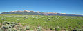
 The Sawtooth Mountains over Open Rangeland.jpg 3,300 × 2,159; 2.22 MB


.jpg)
.jpg)
.jpg)
.jpg)


.jpg)
.jpg)


.jpg)


.jpg)


.jpg)
.jpg)


.jpg)


.jpg)


.jpg)

.jpg)


.jpg)
.jpg)


.jpg)


.jpg)


.jpg)
.jpg)
.jpg)
.jpg)
.jpg)


.jpg)


