Category:Scheepswerf Wolthuis (Sappemeer)
| Object location | | View all coordinates using: OpenStreetMap |
|---|
 | |||||
| Upload media | |||||
| Instance of | |||||
|---|---|---|---|---|---|
| Part of | |||||
| Location | Sappemeer, Midden-Groningen, Groningen, Netherlands | ||||
| Heritage designation |
| ||||
 | |||||
Nederlands: Scheepswerf Wolthuis, Noorderstraat 308, Sappemeer (gem. Hoogezand-Sappemeer, Groningen), rmc 515851. Dit rijksmonumentcomplex omvat:
- dwarshelling (rm 515852)
- werf (rm 515853)
|
This is a category about rijksmonumentcomplex number 515851
|
|
This is a category about rijksmonument number 515852
|
|
This is a category about rijksmonument number 515853
|
Subcategories
This category has only the following subcategory.
Media in category "Scheepswerf Wolthuis (Sappemeer)"
The following 34 files are in this category, out of 34 total.
-
 2014 De Scheepswerf Wolthuis.jpg 5,616 × 3,744; 18.1 MB
-

-
 Interieur werkplaats - Sappemeer - 20388311 - RCE.jpg 1,200 × 1,200; 466 KB
-
 Interieur werkplaats - Sappemeer - 20388312 - RCE.jpg 1,200 × 1,200; 471 KB
-
 Interieur werkplaats - Sappemeer - 20388314 - RCE.jpg 1,200 × 1,200; 417 KB
-
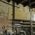 Interieur werkplaats, oostmuur met pleisterwerk - Sappemeer - 20388322 - RCE.jpg 1,200 × 1,200; 467 KB
-
 Interieur werkplaats, smidse - Sappemeer - 20388317 - RCE.jpg 960 × 1,200; 350 KB
-
 Interieur werkplaats, smidse - Sappemeer - 20388318 - RCE.jpg 1,200 × 1,200; 468 KB
-
 Interieur werkplaats, smidse - Sappemeer - 20388319 - RCE.jpg 1,200 × 1,200; 396 KB
-
 Interieur werkplaats, stalen bootromp - Sappemeer - 20388316 - RCE.jpg 1,200 × 1,200; 520 KB
-
 Interieur werkplaats, stalen raam in oostgevel - Sappemeer - 20388320 - RCE.jpg 1,200 × 1,200; 373 KB
-
 Interieur, overzicht werkplaats - Sappemeer - 20388315 - RCE.jpg 1,200 × 1,200; 460 KB
-
 Interieur, vloer in werkplaats met versleten klinkers - Sappemeer - 20388321 - RCE.jpg 1,200 × 1,200; 416 KB
-
 Keet voor werkplaats - Sappemeer - 20388294 - RCE.jpg 1,200 × 1,200; 497 KB
-
 Ligging van de werf met scheepshelling - Sappemeer - 20388291 - RCE.jpg 1,200 × 1,200; 530 KB
-
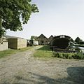
 Omgeving werf - Sappemeer - 20388309 - RCE.jpg 1,200 × 960; 256 KB
-
 Omgeving werf met situering - Sappemeer - 20388305 - RCE.jpg 1,200 × 960; 364 KB
-
 Overzicht achtergevel werkplaats, met bouwsporen - Sappemeer - 20388300 - RCE.jpg 1,200 × 1,200; 487 KB
-
 Overzicht rechterzijgevel, met gedeelte van tuin - Sappemeer - 20388301 - RCE.jpg 1,200 × 1,200; 522 KB
-
 Overzicht van de rechterzijgevel - Sappemeer - 20388299 - RCE.jpg 1,200 × 960; 415 KB
-

-
 Sappemeer - Scheepswerf Wolthuis (1).jpg 6,000 × 3,375; 2.05 MB
-
 Sappemeer - Scheepswerf Wolthuis (2).jpg 5,704 × 3,803; 2.08 MB
-

-
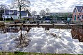
 Situering van de werf aan het water - Sappemeer - 20388302 - RCE.jpg 1,200 × 1,200; 436 KB
-
 Situering werf - Sappemeer - 20388306 - RCE.jpg 1,200 × 1,200; 465 KB
-

-
 Werkplaats, linkerzijgevel - Sappemeer - 20388303 - RCE.jpg 1,200 × 960; 443 KB
-
 Westgevel, roldeuren, vensterbanken zijn gekapt - Sappemeer - 20388292 - RCE.jpg 1,200 × 1,200; 598 KB
-
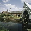
 Zicht op de werf vanaf de overkant van het water - Sappemeer - 20388310 - RCE.jpg 1,200 × 1,200; 441 KB
-
 Zicht op scheepshelling - Sappemeer - 20388296 - RCE.jpg 1,200 × 1,200; 503 KB
-
 Zicht op scheepshelling voor de werkplaats - Sappemeer - 20388295 - RCE.jpg 1,200 × 1,200; 441 KB
-
 Zicht op werf vanaf brug - Sappemeer - 20388307 - RCE.jpg 1,200 × 1,200; 382 KB
-
 Zicht op werf vanaf de overkant van het water - Sappemeer - 20388308 - RCE.jpg 1,200 × 960; 366 KB


.jpg)
.jpg)


