Category:Schloss Waldegg
| Object location | | View all coordinates using: OpenStreetMap |
|---|
castle complex in Feldbrunnen-St. Niklaus in the canton of Solothurn, Switzerland  | |||||
| Upload media | |||||
| Instance of | |||||
|---|---|---|---|---|---|
| Part of | |||||
| Location | Feldbrunnen-St. Niklaus, Lebern District, Solothurn-Lebern, Solothurn, Switzerland | ||||
| Street address |
| ||||
| Heritage designation | |||||
 | |||||
Media in category "Schloss Waldegg"
The following 17 files are in this category, out of 17 total.
-
 Feldbrunnen-StNiklaus-blason.png 267 × 300; 3 KB
-
 CHE Feldbrunnen-St. Niklaus Flag.svg 589 × 585; 51 KB
-
 FeldbrunnenStNiklaus-blazon.svg 209 × 245; 11 KB
-
 Flag of Felbrunnen-St. Niklaus.gif 216 × 216; 4 KB
-
 Schloss Waldegg Feldbrunnen.jpg 2,400 × 600; 789 KB
-
 Schloss Waldegg, Solothurn - panoramio.jpg 2,592 × 1,936; 1.87 MB
-
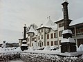
 Schloss waldegg.JPG 3,008 × 2,000; 1.33 MB
-
 Zentralbibliothek Solothurn - CHTEAU DE WALDECK Soleure - a0368.tif 3,330 × 2,333; 22.25 MB
-
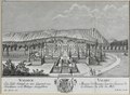
 Zentralbibliothek Solothurn - CHÂTEAU DE WALDECK SOLEURE - a0749.tif 3,350 × 2,399; 23.02 MB
-
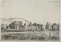 Zentralbibliothek Solothurn - Die Waldegg - a0608.tif 3,577 × 2,476; 25.36 MB
-

-
 Zentralbibliothek Solothurn - VUE DU CHTEAU DE WALDECK PRÈS SOLEURE - aa0161.tif 2,604 × 2,006; 14.97 MB
-

-
-

-
 Besenval par Nattier.jpg 310 × 394; 49 KB
-
 Peter Viktor von Besenval.jpg 1,317 × 1,668; 2.57 MB


