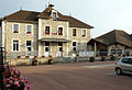
Category:School of Massignieu-de-Rives
| Object location | | View all coordinates using: OpenStreetMap |
|---|
 | |||||
| Upload media | |||||
| Instance of | |||||
|---|---|---|---|---|---|
| Industry |
| ||||
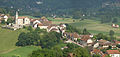
| Location | Massignieu-de-Rives, Ain, Auvergne-Rhône-Alpes, Metropolitan France, France | ||||
| Street address |
| ||||
| Owned by | |||||
| Inception |
| ||||
 | |||||
Media in category "School of Massignieu-de-Rives"
The following 13 files are in this category, out of 13 total.
-
 Massignieu-de-Rives Vue générale 31.JPG 4,095 × 1,938; 5.69 MB
-
 Massignieu-de-Rives École 1.JPG 4,257 × 2,739; 13.12 MB
-
 Massignieu-de-Rives École 2.JPG 2,560 × 1,920; 3.7 MB
-
 Massignieu-de-Rives École 3.JPG 2,560 × 1,842; 2.36 MB
-
 Massignieu-de-Rives École 4.JPG 2,560 × 1,920; 2.38 MB
-
 Massignieu-de-Rives École Mairie.JPG 2,560 × 1,755; 3.65 MB
-
 École Massignieu Rives 1.jpg 5,184 × 3,456; 5.42 MB
-
 École Massignieu Rives 2.jpg 5,184 × 3,456; 6.04 MB
-
 École Massignieu Rives 3.jpg 5,184 × 3,456; 5.89 MB
-
 École Massignieu Rives 4.jpg 5,184 × 3,456; 6.52 MB
-
 École Massignieu Rives 5.jpg 3,456 × 5,184; 6.37 MB
-
 École Massignieu Rives 6.jpg 5,184 × 3,456; 6.78 MB
-
 École Massignieu Rives 7.jpg 5,184 × 3,456; 5.78 MB


