Category:Schootbruggeweg 1, Doornspijk
| Object location | | View all coordinates using: OpenStreetMap |
|---|
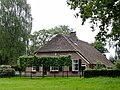
farmhouse in Elburg, Netherlands  | |||||
| Upload media | |||||
| Instance of | |||||
|---|---|---|---|---|---|
| Location | Doornspijk, Gelderland, Netherlands | ||||
| Street address |
| ||||
| Heritage designation |
| ||||
 | |||||
Nederlands: De Knolhoeve
|
This is a category about rijksmonument number 14923
|
| Address |
|
Media in category "Schootbruggeweg 1, Doornspijk"
The following 5 files are in this category, out of 5 total.
-
 Schootbruggeweg1 Wessinge.jpg 3,648 × 2,736; 1.06 MB
-
 Zij- en achtergevel nr. D20-B - Elburg - 20473224 - RCE.jpg 1,200 × 900; 174 KB
-
 Zij- en achtergevel nr. D20-C - Elburg - 20473221 - RCE.jpg 1,200 × 900; 139 KB
-
 Zij- en voorgevel nr. D20-A - Elburg - 20473222 - RCE.jpg 1,200 × 900; 179 KB
-
 Zij- en voorgevel nr. LH153-11 - Elburg - 20473223 - RCE.jpg 1,200 × 900; 187 KB


