Category:Sconser
human settlement in Highland, Scotland, UK .jpg) | |||||
| Upload media | |||||
| Instance of | |||||
|---|---|---|---|---|---|
| Location |
| ||||
 | |||||
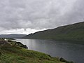
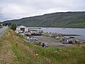
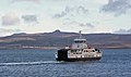
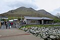
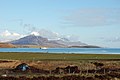
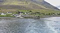
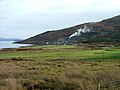
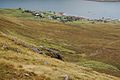
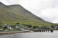
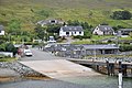
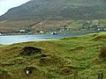
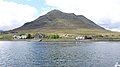
Sconser (Scottish Gaelic: Sgonnsair) is a small crofting township on the Isle of Skye, in Scotland, situated on the south shore of Loch Sligachan. The main A87 road of Skye passes through Sconser and the ferry to Raasay departs from the pier.
Media in category "Sconser"
The following 123 files are in this category, out of 123 total.
-
 A87 - Sconser, Isle of Skye, Scotland, UK - May 19, 1989.jpg 7,500 × 5,000; 22.07 MB
-
 Across Loch Sligachan - geograph.org.uk - 2191241.jpg 1,024 × 768; 751 KB
-
 Across the loch to Sconser - geograph.org.uk - 3063641.jpg 3,000 × 4,000; 2.21 MB
-
 Approaching Sconser Pier - geograph.org.uk - 3080607.jpg 2,448 × 3,264; 1.82 MB
-
 Approaching Sconser-Sgonnsair - geograph.org.uk - 4996874.jpg 3,264 × 2,448; 4.41 MB
-
 Boatyard at Sconser - geograph.org.uk - 3843068.jpg 640 × 480; 205 KB
-
 Bus stop at Sconser Ferry terminal - geograph.org.uk - 4021399.jpg 2,592 × 1,936; 1.61 MB
-
 Caledonian MacBrayne ferry Hallaig - geograph.org.uk - 6614060.jpg 1,600 × 1,037; 226 KB
-
 Caledonian MacBrayne ferry Hallaig - geograph.org.uk - 6616062.jpg 1,600 × 1,200; 273 KB
-

-
 Colourful Coastline - geograph.org.uk - 2374244.jpg 1,600 × 1,098; 581 KB
-
 Corran Glas - geograph.org.uk - 2373236.jpg 640 × 474; 169 KB
-
 Croftland at Sconser - geograph.org.uk - 1561124.jpg 640 × 480; 152 KB
-
 Croftland near Sconser - geograph.org.uk - 1805944.jpg 640 × 480; 91 KB
-
 Departing Sconser - geograph.org.uk - 2094486.jpg 1,024 × 768; 731 KB
-
 End of the Road - geograph.org.uk - 2373646.jpg 1,600 × 1,019; 534 KB
-
 Ferry from Raasay arriving at the Sconser slipway - geograph.org.uk - 1910806.jpg 2,112 × 1,188; 522 KB
-
 Ferry Terminal at Sconser-Sgonnsair - geograph.org.uk - 4996866.jpg 3,264 × 2,448; 3.76 MB
-
 Ferry terminal upgrade - geograph.org.uk - 3473547.jpg 1,280 × 960; 252 KB
-
 Ferry to Raasay Pier - Sconser, Isle of Skye, Scotland, UK - May 19, 1989.jpg 7,500 × 5,000; 24.57 MB
-
 Ferry traffic at Sconser - geograph.org.uk - 1410013.jpg 640 × 480; 106 KB
-
 Golf course at Sconser - geograph.org.uk - 525567.jpg 640 × 425; 299 KB
-
 Grassland, Sconser - geograph.org.uk - 2081721.jpg 640 × 480; 69 KB
-
 Green buoy - geograph.org.uk - 3068062.jpg 2,048 × 1,536; 793 KB
-
 Heading for Sconser - geograph.org.uk - 3068025.jpg 2,048 × 1,536; 780 KB
-
 Isle of Skye Golf Course - geograph.org.uk - 3026709.jpg 4,320 × 3,240; 5.37 MB
-
 Kingdom Hall, Sconser - geograph.org.uk - 1410025.jpg 640 × 480; 105 KB
-
 Leaving Sconser on the Raasay ferry - geograph.org.uk - 3484171.jpg 640 × 480; 82 KB
-
 Loading the MV Hallaig - geograph.org.uk - 4021420.jpg 1,936 × 2,592; 1.89 MB
-
 Local information point, Sconser - geograph.org.uk - 1410011.jpg 640 × 480; 109 KB
-
 Loch Sligachan - geograph.org.uk - 2087815.jpg 640 × 426; 315 KB
-
 Loch Sligachan - geograph.org.uk - 2191247.jpg 1,024 × 768; 578 KB
-
 Loch Sligachan - geograph.org.uk - 2191251.jpg 1,024 × 768; 599 KB
-
 Loch Sligachan - geograph.org.uk - 3063646.jpg 4,000 × 3,000; 2.31 MB
-
 Loch Sligachan - geograph.org.uk - 3633028.jpg 3,648 × 2,736; 3.42 MB
-
 Loch Sligachan - geograph.org.uk - 6613893.jpg 1,200 × 1,558; 321 KB
-
 Loch Sligachan and Corran Ghlas - geograph.org.uk - 4987349.jpg 3,264 × 2,448; 4.17 MB
-
 Loch Sligachan from Sconser - geograph.org.uk - 4987336.jpg 3,264 × 2,448; 4.26 MB
-
 Loch Sligachan in 1999 - geograph.org.uk - 3014772.jpg 1,024 × 691; 137 KB
-
 Loch Sligachan Shoreline - geograph.org.uk - 937698.jpg 640 × 360; 74 KB
-
 Loch Sligachan, Sconser - geograph.org.uk - 2466607.jpg 4,320 × 3,240; 2.91 MB
-
 Lochside in Sconser - geograph.org.uk - 4021387.jpg 2,592 × 1,936; 1.91 MB
-
 Looking along Sconser pier - geograph.org.uk - 1805969.jpg 640 × 480; 71 KB
-
 Looking east at Sconser - geograph.org.uk - 1353689.jpg 640 × 480; 68 KB
-

-
 Marine services yard, Sconser - geograph.org.uk - 1410007.jpg 640 × 480; 102 KB
-
 Moorings at Sconser - geograph.org.uk - 4987384.jpg 3,264 × 2,448; 4.7 MB
-
 Mouth of Loch Sligachan - geograph.org.uk - 2191345.jpg 1,024 × 768; 703 KB
-
 MV Hallaig - geograph.org.uk - 3854677.jpg 1,280 × 762; 773 KB
-
 Northern Coastline of Loch Sligachan - geograph.org.uk - 2389080.jpg 640 × 469; 41 KB
-
 Northern shore of Loch Sligachan - geograph.org.uk - 2191239.jpg 640 × 480; 119 KB
-
 Old road through Sconser - geograph.org.uk - 1410014.jpg 640 × 480; 116 KB
-
 Peinachorrain and the eastern slope of Ben Lee - geograph.org.uk - 5120109.jpg 3,264 × 2,448; 4.48 MB
-
 Pier at Sconser-Sgonnsair - geograph.org.uk - 4996853.jpg 3,264 × 2,448; 4.53 MB
-
 Raasay Ferry - geograph.org.uk - 922926.jpg 640 × 474; 220 KB
-
 Raasay Ferry unloading at Sconcer Pier - geograph.org.uk - 6413497.jpg 1,800 × 1,200; 322 KB
-
 Raasay MV Hallaig 1.jpg 3,968 × 2,976; 5.51 MB
-
 Raasay MV Hallaig 2.jpg 3,968 × 2,976; 8.2 MB
-
 Raasay MV Hallaig 3.jpg 4,608 × 3,456; 8.66 MB
-
 Raasay MV Hallaig 4.jpg 4,608 × 3,456; 9.7 MB
-
 Raasay MV Hallaig 9.jpg 4,608 × 3,456; 8.13 MB
-
 Rainbow over Raasay - geograph.org.uk - 3222790.jpg 2,592 × 1,552; 792 KB
-
 Roadworks at Sconser - geograph.org.uk - 1805983.jpg 640 × 480; 82 KB
-
 Roadworks near Sconser - geograph.org.uk - 1705018.jpg 1,024 × 597; 426 KB
-
 Roadworks near Sconser - geograph.org.uk - 1705026.jpg 640 × 444; 61 KB
-
 Rubha an Torra Mhòir - geograph.org.uk - 5759084.jpg 640 × 336; 173 KB
-
 Rubha an Tòrra Mhòir - geograph.org.uk - 3068054.jpg 2,048 × 1,536; 455 KB
-
 Rubha an Tòrra Mhòir - geograph.org.uk - 5120100.jpg 3,264 × 2,448; 3.93 MB
-
 Rubha an Tòrra Mhòir, seen from the Raasay ferry - geograph.org.uk - 6735794.jpg 4,032 × 3,024; 1.48 MB
-
 Sailing to Raasay - geograph.org.uk - 2373590.jpg 1,600 × 1,016; 526 KB
-
 Sconser - geograph.org.uk - 1410029.jpg 640 × 480; 110 KB
-
 Sconser - geograph.org.uk - 2081729.jpg 480 × 640; 99 KB
-
 Sconser ferry pier - geograph.org.uk - 4021394.jpg 1,936 × 2,592; 2.08 MB
-
 Sconser Ferry Terminal - geograph.org.uk - 5407219.jpg 640 × 427; 306 KB
-
 Sconser Ferry Terminal, Isle of Skye - geograph.org.uk - 5793114.jpg 640 × 480; 59 KB
-
 Sconser from the sea - geograph.org.uk - 2094507.jpg 1,024 × 768; 708 KB
-
 Sconser Golf Course - geograph.org.uk - 124588.jpg 640 × 480; 45 KB
-
 Sconser Golf Course - geograph.org.uk - 757168.jpg 640 × 427; 93 KB
-
 Sconser Isle of Skye - geograph.org.uk - 3232917.jpg 640 × 480; 80 KB
-
 Sconser Lodge Hotel - geograph.org.uk - 135531.jpg 640 × 480; 75 KB
-
 Sconser Lodge Hotel - geograph.org.uk - 1476541.jpg 640 × 480; 62 KB
-
 Sconser Lodge Hotel - geograph.org.uk - 3026719.jpg 4,320 × 3,240; 5.55 MB
-
 Sconser Lodge Hotel - geograph.org.uk - 746809.jpg 640 × 427; 175 KB
-
 Sconser Pier - geograph.org.uk - 1425426.jpg 640 × 427; 52 KB
-
 Sconser pier - geograph.org.uk - 2466579.jpg 4,320 × 3,240; 2.54 MB
-
 Sconser pier - geograph.org.uk - 525550.jpg 640 × 425; 309 KB
-
 Sconser pier for the ferry to Raasay - geograph.org.uk - 4014672.jpg 1,439 × 957; 960 KB
-
 Sconser pier from the departing CalMac ferry, Skye - geograph.org.uk - 1910831.jpg 1,859 × 1,042; 645 KB
-
 Sconser Pier, early April 2018 - geograph.org.uk - 5736834.jpg 640 × 480; 49 KB
-
 Sconser Pier, Loch Sligachan - geograph.org.uk - 937709.jpg 640 × 360; 47 KB
-
 Sconser pier, seen from the car park - geograph.org.uk - 6735783.jpg 4,032 × 3,024; 1.7 MB
-
 Sconser Stone Quarry - geograph.org.uk - 678383.jpg 640 × 480; 71 KB
-
 Sconser to Raasay CalMac ferry arriving at Sconser - geograph.org.uk - 2047724.jpg 4,288 × 2,848; 6.07 MB
-
 Sconser, tin-hut post office - geograph.org.uk - 449074.jpg 640 × 428; 82 KB
-
 Sconser.jpg 640 × 425; 339 KB
-
 Scotland, Isle of Skye, Glamaig seen from Raasay.jpg 4,288 × 2,848; 3.58 MB
-
 Scotland, Isle of Skye, Sconser (1).jpg 4,288 × 2,848; 2.28 MB
-
 Scotland, Isle of Skye, Sconser (2).jpg 4,288 × 2,848; 2.63 MB
-
 Skye shore from the Raasay ferry terminal - geograph.org.uk - 5849357.jpg 2,592 × 1,944; 1.03 MB
-
 Slip, Sconser - geograph.org.uk - 2081728.jpg 640 × 480; 86 KB
-
 Starboard Hand Buoy - geograph.org.uk - 5759088.jpg 640 × 427; 326 KB
-
 Sunrise at the Sconser Lodge Hotel, Isle of Skye - geograph.org.uk - 3166678.jpg 4,320 × 3,240; 5.18 MB
-

-

-

-

-
 The ferry's here^ - geograph.org.uk - 6735780.jpg 3,741 × 2,806; 1.47 MB
-
 The new ferry terminal at Sconser - geograph.org.uk - 4021392.jpg 2,592 × 1,936; 2.3 MB
-
 The Old Schoolhouse, Sconser - geograph.org.uk - 1410021.jpg 640 × 480; 109 KB
-
 The pier at Sconser, Isle of Skye - geograph.org.uk - 1910769.jpg 1,886 × 1,080; 523 KB
-
 The Raasay ferry approaches - geograph.org.uk - 3077114.jpg 3,264 × 2,448; 1.85 MB
-
 The Raasay ferry arriving at Sconser - geograph.org.uk - 2587061.jpg 640 × 480; 371 KB
-
 The Raasay Ferry at Sconser Pier - geograph.org.uk - 321743.jpg 640 × 480; 112 KB
-
 The Raasay ferry, 'Hallaig' - geograph.org.uk - 4996859.jpg 3,264 × 2,448; 2.58 MB
-
 The Sconser Lodge Hotel - geograph.org.uk - 6735799.jpg 4,032 × 3,024; 1.81 MB
-
 The shore of Loch Sligachan near Sconser pier - geograph.org.uk - 1910823.jpg 1,999 × 1,133; 672 KB
-
 The shoreline of Sligachan Loch from the Sconser ferry - geograph.org.uk - 1910848.jpg 2,052 × 1,154; 525 KB
-
 The shoreline west of Sconser pier - geograph.org.uk - 6735772.jpg 4,032 × 3,024; 2.61 MB
-
 Upgrade of Sconser Ferry Terminal - geograph.org.uk - 2823398.jpg 640 × 476; 198 KB
-
 Upgrade work on the Sconser Terminal - geograph.org.uk - 3386519.jpg 640 × 480; 213 KB
-
 View from Sconser Pier - geograph.org.uk - 591112.jpg 640 × 426; 145 KB
-

-
 Works at Sconser - geograph.org.uk - 1705006.jpg 1,024 × 768; 830 KB


.jpg)


