Category:September 2013 in Oxford
Deutsch: Bilder, die im September 2013 in Oxford aufgenommen worden sind. Bitte beachten Sie, dass dies weder das Datum des Uploads noch das Datum des Scannens eines Fotos ist.
English: Images/pictures taken in Oxford during September 2013. Note this is not the date of the upload, nor the date a photo was scanned.
Español: Fotografías o imágenes tomadas en Oxford durante septiembre 2013. No es la fecha de subida ni escaneo, sino la fecha en que las fotografías o imágenes se crearon.
Esperanto: Bildoj faritaj en Oxford en septembro 2013. Tio ne estas la dato, kiam la bildoj estis alŝutitaj aŭ skanitaj.
Français : Photographies ou images prises en Oxford durant septembre 2013. Ce n'est pas la date du téléchargement ou du scan.
Galego: Fotografías ou imaxes tomadas en Oxford durante setembro 2013. Non é a data de subida nin escaneamento, senón a data na que se crearon as fotografías ou imaxes.
Italiano: Fotografie o immagini scattate a Oxford nel settembre 2013. Nota bene: la data non si riferisce né a quella di upload né a quella in cui la foto è stata digitalizzata.
Norsk bokmål: Bilder tatt i Oxford i løpet av september 2013. Merk at dette ikke er datoen for opplasting, eller når et bilde har blitt skannet.
Norsk nynorsk: Bilete teke i Oxford i løpet av september 2013. Merk at dette ikkje er datoen for opplasting, eller når eit bilete har vorte skanna.
Русский: Изображения, сделанные в Oxford в течение сентябрь 2013 (не дата загрузки изображения).
Українська: Зображення, зроблені в Oxford протягом вересень 2013. Зауважте, що це не дата завантаження чи дата сканування фотографії.
| September 2012 | ← | September 2013 | → | September 2014 | |||||||
| Jan | Feb | Mar | Apr | May | Jun | Jul | Aug | Sep | Oct | Nov | Dec |
| 30 | 17 | 48 | 42 | 11 | 11 | 33 | 42 | 42 | 1 | 0 | 0 |
|---|---|---|---|---|---|---|---|---|---|---|---|
Media in category "September 2013 in Oxford"
The following 42 files are in this category, out of 42 total.
-
 A lonely GR pillar box beside Rock Edge - geograph.org.uk - 3684160.jpg 1,024 × 683; 185 KB
-
 Aerial view of Plant Oxford.jpg 940 × 705; 281 KB
-
 All Saints Church, Lime Walk - geograph.org.uk - 3687239.jpg 1,024 × 683; 243 KB
-
 Benchmark at entrance to ^50 Copse Lane - geograph.org.uk - 3680698.jpg 649 × 1,024; 279 KB
-
 Benchmark below the pebbledash on ^23 Ash Grove - geograph.org.uk - 3679869.jpg 683 × 1,024; 298 KB
-
 Benchmark on buttress of All Saints Church - geograph.org.uk - 3687231.jpg 1,024 × 683; 221 KB
-

-
 Benchmark on St Andrew's Church - geograph.org.uk - 3679960.jpg 683 × 1,024; 286 KB
-
 Benchmark on St Andrew's Road wall - geograph.org.uk - 3680118.jpg 683 × 1,024; 334 KB
-
 Benchmark on St Andrews CP School, London Road - geograph.org.uk - 3679773.jpg 1,024 × 683; 296 KB
-

-
 Benchmark on The Manor Farm house - geograph.org.uk - 3680284.jpg 683 × 1,024; 276 KB
-
 Benchmark on wall of ^67 Old Road - geograph.org.uk - 3685829.jpg 683 × 1,024; 274 KB
-
 Benchmark on ^1 Saxon Way - geograph.org.uk - 3680479.jpg 688 × 1,024; 249 KB
-
 Benchmark on ^104 Lime Walk - geograph.org.uk - 3684789.jpg 683 × 1,024; 251 KB
-
 Benchmark on ^12 Sandfield Road - geograph.org.uk - 3678881.jpg 683 × 1,024; 248 KB
-
 Benchmark on ^19 Saxon Way - geograph.org.uk - 3680602.jpg 683 × 1,024; 254 KB
-
 Benchmark on ^2 Stoke Place - geograph.org.uk - 3680210.jpg 746 × 1,024; 279 KB
-
 Benchmark on ^24 Bowness Avenue - geograph.org.uk - 3680801.jpg 683 × 1,024; 239 KB
-
 Benchmark on ^26 Old High Street - geograph.org.uk - 3687286.jpg 683 × 1,024; 212 KB
-
 Benchmark on ^31 Old Road - geograph.org.uk - 3686939.jpg 683 × 1,024; 294 KB
-
 Benchmark on ^40 Sandfield Road - geograph.org.uk - 3678533.jpg 683 × 1,024; 256 KB
-
 Benchmark on ^45 Sandfield Road - geograph.org.uk - 3676896.jpg 683 × 1,024; 307 KB
-
 Benchmark on ^56 Staunton Road - geograph.org.uk - 3678871.jpg 707 × 1,024; 213 KB
-
 Benchmark on ^61 Old Road - geograph.org.uk - 3685843.jpg 683 × 1,024; 222 KB
-
 Benchmark on ^69 London Road - geograph.org.uk - 3679410.jpg 683 × 1,024; 239 KB
-
 Benchmarked milestone on Headington Road - geograph.org.uk - 3680876.jpg 683 × 1,024; 252 KB
-
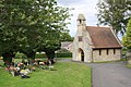 Chapel in Headington Cemetery off Dunstan Road - geograph.org.uk - 3680339.jpg 1,024 × 683; 256 KB
-
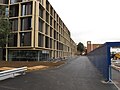
 Construction site, Blavatnik School of Government, Oxford - geograph.org.uk - 3657835.jpg 3,648 × 2,736; 1.79 MB
-
 Cowley and Oxford (geograph 3639674).jpg 3,264 × 2,448; 3.92 MB
-
 Damaged benchmark on Headington Post Office - geograph.org.uk - 3684110.jpg 755 × 1,024; 238 KB
-
 East end of Meadow Building, Christ Church College - geograph.org.uk - 3671998.jpg 2,000 × 2,474; 2.06 MB
-
 Model of Radcliffe Observatory Quarter redevelopment - geograph.org.uk - 3653823.jpg 3,648 × 2,736; 1.73 MB
-

-
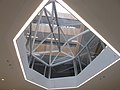
 New Mathematical Institute, Oxford - common room - geograph.org.uk - 3657802.jpg 3,648 × 2,736; 1.7 MB
-
 New Mathematical Institute, Oxford - main entrance - geograph.org.uk - 3654080.jpg 3,648 × 2,736; 2.49 MB
-
 New Mathematical Institute, Oxford - north crystal - geograph.org.uk - 3654097.jpg 3,648 × 2,736; 1.85 MB
-
-
 New student accommodation, Somerville College Oxford - geograph.org.uk - 3657829.jpg 3,290 × 2,706; 1.25 MB
-
 Magdalen College - view on the tower and the chapel.jpg 6,331 × 4,613; 7.78 MB
-
 Volvo B10M Plaxton Premiere M407 BFG Oxford StGiles.jpg 839 × 564; 334 KB
-
 ^1 Saxon Way - geograph.org.uk - 3680524.jpg 1,024 × 683; 156 KB


.jpg)


