Category:Seventh-Day Adventist church in Zakopane
| Object location | | View all coordinates using: OpenStreetMap |
|---|
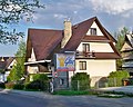
Polski: Dom modlitwy adwentystów, Zakopane, ul. W. Broniewskiego 10
 | |||||
| Upload media | |||||
| Instance of |
| ||||
|---|---|---|---|---|---|
| Location | Zakopane, Tatra County, Lesser Poland Voivodeship, Poland | ||||
| Diocese | |||||
| Inception |
| ||||
| official website | |||||
 | |||||
Media in category "Seventh-Day Adventist church in Zakopane"
The following 2 files are in this category, out of 2 total.
-
 Zbór adwentystów zakopane 1.jpg 3,592 × 2,727; 5.33 MB
-
 Zbór adwentystów zakopane 2.jpg 3,492 × 2,783; 2.06 MB
