Category:ShakeMaps of earthquakes in Argentina
Media in category "ShakeMaps of earthquakes in Argentina"
The following 13 files are in this category, out of 13 total.
-
 1950 Calama earthquake.jpg 906 × 1,079; 414 KB
-
 1960 Valdivia earthquake.jpg 822 × 1,084; 325 KB
-
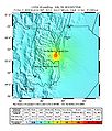 2009 Salta earthquake map.jpg 612 × 716; 113 KB
-
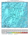
 2010 Salta earthquake map.jpg 612 × 707; 126 KB
-
 2019-09-27 Villa La Angostura, Argentina M6.1 earthquake shakemap (USGS).jpg 844 × 1,068; 388 KB
-
 2019-12-24 El Hoyo, Argentina M6 earthquake shakemap (USGS).jpg 838 × 1,026; 205 KB
-

-
 2021-01-19 Pocito, Argentina M6.4 earthquake shakemap (USGS).jpg 786 × 996; 330 KB
-
-
 2022-02-22 Abra Pampa, Argentina M6 earthquake shakemap (USGS).jpg 787 × 998; 171 KB
-
 2022-05-10 Jujuy, Argentina M6.8 earthquake shakemap (USGS).jpg 787 × 1,001; 182 KB
-

-
 February 2010 Salta earthquake intensity USGS.jpg 612 × 707; 122 KB


.jpg)
.jpg)
.jpg)
.jpg)
.jpg)
.jpg)
.jpg)
.jpg)
