Category:ShakeMaps of earthquakes in Greece
Media in category "ShakeMaps of earthquakes in Greece"
The following 22 files are in this category, out of 22 total.
-
 1953 Ionian earthquake shakemap.jpg 787 × 1,013; 285 KB
-
 1986 Kalamata Greece earthquake shakemap.jpg 797 × 1,001; 282 KB
-
 2008 Greece earthquake.jpg 457 × 458; 60 KB
-
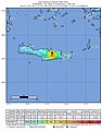
 2015 Lefkada earthquake.jpg 612 × 719; 89 KB
-
 2017 Kos earthquake intensity map.jpg 787 × 1,001; 297 KB
-
 2018-10-25 Mouzaki, Greece M6.8 earthquake shakemap (USGS).jpg 612 × 719; 94 KB
-
 2019-11-27 Platanos, Greece M6 earthquake shakemap (USGS).jpg 813 × 1,029; 172 KB
-
 2020-05-02 Ierapetra, Greece M6.6 earthquake shakemap (USGS).jpg 801 × 1,003; 165 KB
-
 2020-10-30 Néon Karlovásion, Greece M7 earthquake shakemap (USGS).jpg 796 × 980; 384 KB
-
 2021 Crete earthquake shakemap.jpg 787 × 1,000; 195 KB
-
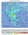
 2021-03-03 M 6.3 - 10 km WNW of Týrnavos, Greece.jpg 787 × 999; 377 KB
-
 2021-03-03 Týrnavos, Greece M6.3 earthquake shakemap (USGS).jpg 787 × 999; 379 KB
-
 2021-09-27 Crete, Greece M6.0 earthquake shakemap (USGS).jpg 787 × 1,000; 186 KB
-
 2021-10-12 Crete, Greece M6.4 earthquake shakemap (USGS).jpg 787 × 1,000; 257 KB
-
 2021-10-12 Palekastro, Greece M6.4 earthquake shakemap (USGS).jpg 787 × 1,000; 247 KB
-
 Earthquake02-14-08.jpg 612 × 710; 85 KB
-
 M 6.3 - 5km S of Plomarion, Greece - intensity.jpg 612 × 718; 113 KB
-
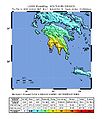
 M 6.6 - 10 km W of Aianí, Greece.jpg 789 × 971; 392 KB
-
 M-6.5-8-km-WNW-of-Galaxídhion -Greece.png 787 × 989; 758 KB
-
 USGS Shakemap - 1978 Thessaloniki earthquake.jpg 612 × 719; 126 KB
-
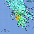
 USGS Shakemap - 2008 Peloponnese earthquake.jpg 612 × 719; 102 KB
-
 USGS Shakemap - 2014 Aegean Sea earthquake.jpg 612 × 719; 123 KB


.jpg)
.jpg)
.jpg)
.jpg)


.jpg)
.jpg)
.jpg)
.jpg)


