Category:ShakeMaps of earthquakes in Japan
Countries of Asia: Afghanistan · Armenia‡ · People's Republic of China · Cyprus‡ · East Timor · Georgia‡ · India · Indonesia‡ · Iran · Japan · Laos · Malaysia · Mongolia · Myanmar · Nepal · Pakistan · Philippines · Russia‡ · South Korea · Thailand · Turkey‡
Limited recognition: Taiwan
‡: partly located in Asia
Limited recognition: Taiwan
‡: partly located in Asia
Media in category "ShakeMaps of earthquakes in Japan"
The following 73 files are in this category, out of 73 total.
-
 1993 Kushiro earthquake shakemap.jpg 612 × 719; 86 KB
-
 1993 Okushiri earthquake shakemap.jpg 612 × 719; 83 KB
-
 2000 Izu Islands earthquake (M 6.5) shakemap.jpg 787 × 1,000; 214 KB
-
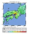
 2000 Tottori earthquake shakemap.jpg 612 × 719; 148 KB
-
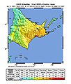
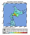
 2003 Hokkaido earthquake shakemap.jpg 612 × 723; 103 KB
-
 2006 Kuril Islands Earthquake Location.jpg 612 × 721; 100 KB
-
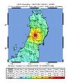 2008-Iwate-Earthquake-Intensity.jpg 612 × 711; 92 KB
-
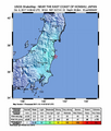
 2010 Honshu Shakemap.jpg 612 × 711; 92 KB
-
 2010 Japan earthquake map.jpg 612 × 712; 56 KB
-
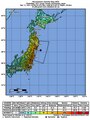
 2011 Japan shakemap.jpg 760 × 1,016; 242 KB
-
 2018 Iburi earthquake intensity map.jpg 612 × 719; 81 KB
-
 2018 Osaka earthquake intensity map.jpg 612 × 719; 101 KB
-
 2019-01-08 Nishinoomote, Japan M6.3 earthquake shakemap (USGS).jpg 888 × 1,072; 184 KB
-
 2019-03-02 Nemuro, Japan M6 earthquake shakemap (USGS).jpg 882 × 1,083; 147 KB
-
 2019-04-11 Miyako, Japan M6 earthquake shakemap (USGS).jpg 888 × 1,070; 150 KB
-
 2019-04-11 Miyako, Japan M6.1 earthquake shakemap (USGS).jpg 888 × 1,070; 149 KB
-
 2019-05-09 Miyazaki-shi, Japan M6.1 earthquake shakemap (USGS).jpg 888 × 1,071; 221 KB
-
 2019-06-18 Tsuruoka, Japan M6.4 earthquake shakemap (USGS).jpg 867 × 1,070; 326 KB
-
 2019-07-13 Naze, Japan M6.1 earthquake shakemap (USGS).jpg 846 × 1,069; 149 KB
-
 2019-07-27 Shingu, Japan M6.3 earthquake shakemap (USGS).jpg 846 × 1,067; 151 KB
-
 2019-08-04 Namie, Japan M6.3 earthquake shakemap (USGS).jpg 855 × 1,069; 219 KB
-
 2019-08-28 Hachinohe, Japan M6.1 earthquake shakemap (USGS).jpg 855 × 1,067; 146 KB
-
 2020-04-18 Chichi-shima, Japan M6.6 earthquake shakemap (USGS).jpg 801 × 1,000; 138 KB
-
 2020-04-19 Ofunato, Japan M6.3 earthquake shakemap (USGS).jpg 807 × 1,008; 229 KB
-
 2020-06-13 Naze, Japan M6.6 earthquake shakemap (USGS).jpg 787 × 1,000; 138 KB
-
 2020-09-12 Ōfunato, Japan M6.1 earthquake shakemap (USGS).jpg 787 × 1,000; 238 KB
-
 2020-12-20 Hachinohe, Japan M6.3 earthquake shakemap (USGS).jpg 786 × 1,001; 225 KB
-
 2021-02-13 Honshu, Japan M7.1 earthquake shakemap (USGS).jpg 769 × 1,001; 240 KB
-
 2021-02-13 Namie, Japan M7 earthquake shakemap (USGS).jpg 787 × 998; 229 KB
-
 2021-02-13 Namie, Japan M7.1 earthquake shakemap (USGS).jpg 787 × 998; 226 KB
-
 2021-03-20 Ishinomaki, Japan M7 earthquake shakemap (USGS).jpg 787 × 999; 235 KB
-
 2021-05-01 Ishinomaki, Japan M6.8 earthquake shakemap (USGS).jpg 787 × 1,001; 248 KB
-
 2021-05-13 Namie, Japan M6 earthquake shakemap (USGS).jpg 801 × 998; 240 KB
-
 2021-09-29 Nanao, Japan M6.1 earthquake shakemap (USGS).jpg 787 × 1,000; 132 KB
-
 2021-11-10 Hirara, Japan M6.6 earthquake shakemap (USGS).jpg 787 × 997; 143 KB
-
 2021-11-29 Izu Islands, Japan region M6.3 earthquake shakemap (USGS).jpg 787 × 1,002; 142 KB
-
 2021-12-09 Naze, Japan M6 earthquake shakemap (USGS).jpg 787 × 997; 148 KB
-
 2021-12-09 Ryukyu Islands, Japan M6 earthquake shakemap (USGS).jpg 791 × 1,000; 158 KB
-
 2022-01-21 Saiki, Japan M6.3 earthquake shakemap (USGS).jpg 787 × 1,000; 313 KB
-
 2022-03-16 Namie, Japan M6 earthquake shakemap (USGS).jpg 788 × 1,004; 124 KB
-
 2022-03-16 Namie, Japan M6.4 earthquake shakemap (USGS).jpg 788 × 1,003; 123 KB
-
 2022-03-16 Namie, Japan M6.5 earthquake shakemap (USGS).jpg 788 × 1,003; 125 KB
-
 2022-03-16 Namie, Japan M7.3 earthquake shakemap (USGS).jpg 788 × 1,003; 120 KB
-
 2022-05-09 Yonakuni, Japan M6.3 earthquake shakemap (USGS).jpg 788 × 1,001; 106 KB
-
 2022-05-22 Katsuura, Japan M6 earthquake shakemap (USGS).jpg 788 × 1,006; 77 KB
-
 2022-11-14 Toba, Japan M6.1 earthquake shakemap (USGS).jpg 788 × 1,001; 121 KB
-
 2023-02-25 Kushiro, Japan M6 earthquake shakemap (USGS).jpg 788 × 1,004; 113 KB
-
 2023-02-25 Kushiro, Japan M6.1 earthquake shakemap (USGS).jpg 787 × 1,005; 114 KB
-
 2023-03-28 Misawa, Japan M6 earthquake shakemap (USGS).jpg 787 × 1,004; 113 KB
-
 2024-01-01 Japan M7.5 earthquake shakemap (USGS).jpg 789 × 984; 153 KB
-
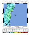
 9th March 2011 Sanriku earthquake - ShakeMap.jpg 612 × 718; 79 KB
-
 April 12 2011 Fukushima earthquake shake map.jpg 612 × 718; 107 KB
-
 April11 2011 Fukushima earthquake shake map.jpg 612 × 706; 100 KB
-
 Earthquake Japan 2011-03-27.jpg 612 × 715; 84 KB
-
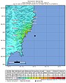
 Intensity - M 6.0 - 255km ESE of Ishinomaki, Japan.jpg 612 × 719; 73 KB
-
 Intensity 2007 July Japan.jpg 612 × 718; 155 KB
-
 Intensity of the offshore earthquake in Fukushima in Oct 2017.png 612 × 719; 330 KB
-
 Intensity of the offshore earthquake in Iwate in 2017.jpg 612 × 719; 86 KB
-
 Izuhanto East Quake 2006.jpg 612 × 716; 129 KB
-
 Japan quake July 16.2007.jpg 612 × 713; 149 KB
-
 Japan Shakemap 15 April 2016.jpg 612 × 718; 96 KB
-
 Japan Shakemap April 2016.jpg 612 × 718; 94 KB
-
 M 7.7 - Hokkaido, Japan region - Shakemap.jpg 612 × 719; 73 KB
-
 M5.5 - 2km NNE of Moriya, Japan.jpg 612 × 718; 100 KB
-
 ShakeMap of The 2011 off the Pacific coast of Tohoku Earthquake.pdf 1,189 × 1,587; 3.79 MB
-
 Shizuoka Earthquake Shakemap 20090811.jpg 612 × 709; 107 KB
-
 Shizuoka Earthquake Shakemap 20110315.jpg 612 × 704; 101 KB
-
 Shizuoka Earthquake Shaking Intensity Map 20090811.jpg 600 × 611; 45 KB
-
 USGS Shakemap - 1995 Kobe earthquake.jpg 612 × 713; 140 KB
-
 USGS Shakemap - 2005 Miyagi earthquake.jpg 612 × 717; 126 KB
-
 USGS ShakeMap 2008tfdp.jpg 612 × 719; 92 KB
-
 USGS ShakeMap 2008urah.jpg 612 × 710; 87 KB
-
 USGS ShakeMap 2008uva4.jpg 612 × 716; 88 KB


_shakemap.jpg)


.jpg)
.jpg)
.jpg)
.jpg)
.jpg)
.jpg)
.jpg)
.jpg)
.jpg)
.jpg)
.jpg)
.jpg)
.jpg)
.jpg)
.jpg)
.jpg)
.jpg)
.jpg)
.jpg)
.jpg)
.jpg)
.jpg)
.jpg)
.jpg)
.jpg)
.jpg)
.jpg)
.jpg)
.jpg)
.jpg)
.jpg)
.jpg)
.jpg)
.jpg)
.jpg)
.jpg)
.jpg)


.jpg)