Category:Sharon, Massachusetts
city in Massachusetts     | |||||
| Upload media | |||||
| Instance of | |||||
|---|---|---|---|---|---|
| Part of | |||||
| Location | Norfolk County, Massachusetts | ||||
| Inception |
| ||||
| Population |
| ||||
| Area |
| ||||
| Elevation above sea level |
| ||||
| official website | |||||
 | |||||
Subcategories
This category has the following 9 subcategories, out of 9 total.
B
- Borderland State Park (7 F)
C
- Cobb's Tavern (11 F)
L
- Lake Massapoag (5 F)
M
- Moose Hill Farm (8 F)
P
S
- Deborah Sampson (militar) (27 F)
Media in category "Sharon, Massachusetts"
The following 32 files are in this category, out of 32 total.
-
 1888 Sharon Heights and Massapoag Pond map.jpg 409 × 532; 52 KB
-
 Arnold Jason Aronson - US Merchant Marine World War II Sharon Memorial Park.jpg 2,629 × 1,382; 918 KB
-
 Carduelis pinus feeding wsweet321.jpg 3,264 × 2,448; 1.87 MB
-
 Carduelis pinus wsweet321.jpg 1,866 × 1,400; 365 KB
-

-
 DSC 2765 (14108196356).jpg 4,496 × 3,000; 6.82 MB
-
 Flag of Sharon, Massachusetts.gif 380 × 260; 12 KB
-

-
 MBTA 1101 on the Northeast Corridor (1), June 1982.jpg 2,000 × 1,613; 3.61 MB
-
 MBTA 1101 on the Northeast Corridor (2), June 1982.jpg 2,000 × 1,578; 3.48 MB
-
 New Sharon High School.jpg 6,048 × 4,024; 15.63 MB
-

-

-
 Old home week, 1906, Sharon, Massachusetts, souvenir program .. (IA oldhomeweek1906s00shar).pdf 816 × 1,322, 28 pages; 1.26 MB
-
 Origin and early history of the first parish, Sharon, Massachusetts (IA originearlyhisto00cook).pdf 841 × 1,308, 40 pages; 1.62 MB
-

-

-
 Seal of Sharon, Massachusetts.gif 150 × 160; 8 KB
-
 Seal of Sharon, Massachusetts.png 472 × 500; 331 KB
-
 Sharon High School, Sharon MA.jpg 5,472 × 3,648; 5.05 MB
-
 Sharon ma highlight.png 788 × 466; 54 KB
-
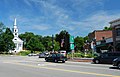
 Sharon MA Town Center.jpg 1,500 × 1,004; 386 KB
-
 Sharon Mass Historic Center.jpg 3,430 × 2,190; 1.28 MB
-
 Sharon Memorial Park, Massachusetts - USA.jpg 2,739 × 1,359; 537 KB
-
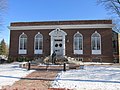 Sharon Public Library, Sharon MA.jpg 3,264 × 2,448; 2.44 MB
-
 Sharon-public-library.jpeg 1,932 × 2,576; 1.33 MB
-
 SharonMA CharlesRWilberSchool.jpg 1,024 × 680; 188 KB
-
 SharonMA GavinsPondDam.jpg 1,024 × 680; 208 KB
-
 SharonMA Stoneholm.jpg 1,024 × 680; 239 KB
-
 Sharon, Massachusetts. The healthiest town in New England .. (IA sharonmassachuse01wickes).pdf 831 × 1,310, 36 pages; 1.66 MB
-
 Unitarian Church, Sharon MA.jpg 1,695 × 2,540; 704 KB
-
 Wsweet321 - Dragonfly (by).jpg 1,867 × 1,400; 308 KB


.jpg)

,_June_1982.jpg)
,_June_1982.jpg)

_highlighted.svg)

_(14775805661).jpg)


.jpg)