Category:Shildon railway station
English: Shildon railway station
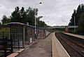
serves Shildon, County Durham. It is on the Tees Valley Line inbetween Bishop Auckland station to the west (end of the line) and Newton Aycliffe station to the east. The station also serves the Locomotion railway museum, which is accessed directly from the exit in the southern (westbound) platform. The line west curves away from the museum site, but to the east it parallels it. To the east, overlooking the museum track, is Shildon signal box, and beyond that the Spout Lane road bridge.
| Object location | | View all coordinates using: OpenStreetMap |
|---|
railway station in County Durham, England, UK  | |||||
| Upload media | |||||
| Instance of | |||||
|---|---|---|---|---|---|
| Named after | |||||
| Location | Shildon, County Durham, North East England, England | ||||
| Operator |
| ||||
| Date of official opening |
| ||||
 | |||||
Media in category "Shildon railway station"
The following 26 files are in this category, out of 26 total.
-
 142020 at Shildon 11th January 2018.jpg 4,608 × 3,456; 6.15 MB
-
 156 454 Northern Shildon 08-01-16 (24061306230).jpg 4,205 × 2,777; 6.78 MB
-
 NRM Shildon - 51352982018.jpg 2,272 × 1,704; 3.26 MB
-
 NRM Shildon - 51352982093.jpg 2,647 × 1,985; 4.57 MB
-
 NRM Shildon - 51353494949.jpg 2,191 × 1,643; 3.05 MB
-
 NRM Shildon - 51353777785.jpg 2,164 × 1,623; 3.7 MB
-
 Railway North of Shildon station - geograph.org.uk - 3435662.jpg 640 × 480; 98 KB
-
 Railway route south-east from Shildon Station - geograph.org.uk - 5676088.jpg 1,500 × 1,099; 1.44 MB
-
 Railway to Bishop Auckland - geograph.org.uk - 6355178.jpg 4,032 × 3,024; 7 MB
-
 Shildon platform 1 - geograph.org.uk - 6355181.jpg 4,032 × 3,024; 5.8 MB
-
 Shildon Railway Station - geograph.org.uk - 2479339.jpg 1,280 × 960; 751 KB
-
 Shildon railway station MMB 01 142023.jpg 3,738 × 2,523; 3.19 MB
-
 Shildon railway station MMB 02 142023.jpg 3,830 × 2,361; 3.79 MB
-
 Shildon railway station MMB 03.jpg 3,822 × 2,468; 2.81 MB
-
 Shildon railway station MMB 04.jpg 3,840 × 2,578; 3.84 MB
-
 Shildon railway station, County Durham - geograph.org.uk - 3276733.jpg 1,024 × 731; 167 KB
-
 Shildon railway station, County Durham - geograph.org.uk - 3276741.jpg 1,024 × 731; 107 KB
-
 Shildon railway station.jpg 2,272 × 1,504; 1.66 MB
-
 Shildon Signal Box and Spout Lane Bridge - geograph.org.uk - 2479332.jpg 1,280 × 960; 686 KB
-
 Shildon station - geograph.org.uk - 3238590.jpg 640 × 425; 176 KB
-
 Shildon Station - geograph.org.uk - 3435650.jpg 640 × 480; 102 KB
-
 Shildon station - geograph.org.uk - 3857064.jpg 4,000 × 3,000; 2.78 MB
-
 Shildon Station - geograph.org.uk - 4286029.jpg 1,280 × 851; 373 KB
-
 Shildon Station - geograph.org.uk - 4286031.jpg 851 × 1,280; 314 KB
-
 Shildon Station - geograph.org.uk - 96548.jpg 640 × 480; 98 KB
-
 Shildon station looking eastwards - geograph.org.uk - 6134207.jpg 5,202 × 3,465; 4.5 MB

.jpg)


