Category:Shire of West Wimmera
Deutsch: West Wimmera Shire ist ein lokales Verwaltungsgebiet (LGA) im australischen Bundesstaat Victoria. Das Gebiet ist 9.030 km² groß und mit unter 5.000 Einwohnern nach Bevölkerung die zweitkleinste LGA nach dem Queenscliffe Borough. (→West Wimmera Shire)
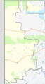
English: The Shire of West Wimmera is a local government area in the western part of the Wimmera region of Victoria, Australia, located in the western part of the state. It covers an area of and, at the 2011 Census, had a population of 4,251. It includes the towns of Apsley, Edenhope, Goroke, Gymbowen, Harrow, Kaniva, Minimay, Nurcoung and Serviceton. It was formed in 1995 from the amalgamation of the Shire of Kaniva and parts of the Shire of Kowree, Shire of Arapiles and Shire of Glenelg. (→Shire of West Wimmera)
Français : Le comté de Wimmera Ouest est une zone d'administration locale dans l'ouest du Victoria en Australie. (→Comté de Wimmera Ouest)
Italiano: La Contea di West Wimmera è una Local Government Area che si trova nello stato di Victoria. Essa si estende su di una superficie di 9.107 chilometri quadrati ed ha una popolazione di 4.251 abitanti. La sede del consiglio si trova a Edenhope. (→Contea di West Wimmera)
Nederlands: West Wimmera Shire is een Local Government Area (LGA) in Australië in de staat Victoria. West Wimmera Shire telt 4.697 inwoners. De hoofdplaats is Edenhope. (→West Wimmera Shire)
local government area in Victoria, Australia | |||||
| Upload media | |||||
| Instance of | |||||
|---|---|---|---|---|---|
| Location | Victoria, AUS | ||||
| Capital | |||||
| Population |
| ||||
| Area |
| ||||
| Elevation above sea level |
| ||||
| official website | |||||
 | |||||
Subcategories
This category has the following 6 subcategories, out of 6 total.
E
- Edenhope, Victoria (6 F)
G
- Goroke, Victoria (3 F)
- Gymbowen, Victoria (2 F)
H
M
- Minimay, Victoria (3 F)
S
Media in category "Shire of West Wimmera"
The following 2 files are in this category, out of 2 total.
-
 Australia Victoria West Wimmera Shire location map.svg 533 × 990; 512 KB
-
 Australia-Map-VIC-LGA-West Wimmera.png 550 × 400; 8 KB

