Category:Singsaas Lutheran Church (Brookings County, South Dakota)
| Object location | | View all coordinates using: OpenStreetMap |
|---|
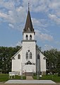
church building in South Dakota, United States of America  | |||||
| Upload media | |||||
| Instance of | |||||
|---|---|---|---|---|---|
| Location | South Dakota | ||||
| Heritage designation |
| ||||
| Religion or worldview | |||||
 | |||||
|
This is a category about a place or building that is listed on the National Register of Historic Places in the United States of America. Its reference number is 03001070. |
Media in category "Singsaas Lutheran Church (Brookings County, South Dakota)"
The following 19 files are in this category, out of 19 total.
-
 Singsaas Lutheran Church from E 1.jpg 1,597 × 2,262; 712 KB
-
 Singsaas Lutheran Church from ESE 1.jpg 1,723 × 1,802; 645 KB
-
 Singsaas Lutheran Church from NE 1 address.jpg 1,310 × 2,478; 727 KB
-
 Singsaas Lutheran Church from NE 2.jpg 1,503 × 1,724; 425 KB
-
 Singsaas Lutheran Church from S 1.jpg 2,506 × 1,816; 809 KB
-
 Singsaas Lutheran Church from SE 1.jpg 1,589 × 1,827; 576 KB
-
 Singsaas Lutheran Church from SSE 1.jpg 2,559 × 1,812; 943 KB
-
 Singsaas Lutheran Church from SW 1.jpg 1,820 × 1,703; 571 KB
-
 Singsaas Lutheran Church, interior 01.jpg 2,560 × 1,920; 2.09 MB
-
 Singsaas Lutheran Church, interior 02.jpg 2,560 × 1,920; 2.04 MB
-
 Singsaas Lutheran Church, interior 03.jpg 1,920 × 2,560; 1.97 MB
-
 Singsaas Lutheran Church, interior 04.jpg 2,560 × 1,920; 2.03 MB
-
 Singsaas Lutheran Church, interior 05.jpg 2,560 × 1,920; 1.99 MB
-
 Singsaas Lutheran Church, interior 06.jpg 2,560 × 1,920; 1.97 MB
-
 Singsaas Lutheran Church, interior 07.jpg 2,560 × 1,920; 2.02 MB
-
 Singsaas Lutheran Church, interior 08.jpg 1,920 × 2,560; 1.99 MB
-
 Singsaas Lutheran Church, interior 09.jpg 2,560 × 1,920; 2.06 MB
-
 Singsaas Lutheran Church, interior 10.jpg 1,855 × 2,475; 908 KB
-
 Singsaas Lutheran Church, interior 11.jpg 2,560 × 1,920; 2.09 MB


