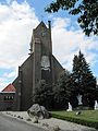
Category:Sint-Franciscuskerk (Steenwijksmoer)
| Object location | | View all coordinates using: OpenStreetMap |
|---|
church building in Coevorden, Netherlands  | |||||
| Upload media | |||||
| Instance of | |||||
|---|---|---|---|---|---|
| Location | Steenwijksmoer, Coevorden, Drenthe, Netherlands | ||||
| Street address |
| ||||
| Architect | |||||
| Heritage designation |
| ||||
| Religion or worldview | |||||
 | |||||
Nederlands: Franciscuskerk, Steenwijksmoer - anno 1932
|
This is a category about rijksmonument number 468597
|
| Address |
|
Media in category "Sint-Franciscuskerk (Steenwijksmoer)"
The following 11 files are in this category, out of 11 total.
-
 Beeld van de H. aartsengel Michael.jpg 1,959 × 4,582; 1.79 MB
-
 Beeld van de H. Paulus.jpg 1,749 × 4,411; 1.55 MB
-
 Beeld van de H. Petrus.jpg 1,953 × 4,477; 1.91 MB
-
-
 Foto boven hoofdingang.jpg 6,000 × 4,000; 8.7 MB
-
 Laatste avondmaal wiki.jpg 4,032 × 3,024; 3.57 MB
-
 Overzichtsfoto Steenwijksmoer.jpg 6,000 × 4,000; 8.03 MB
-
 St Fransiscus in Steenwijksmoer.jpg 4,079 × 2,709; 9.21 MB
-
 Steenwijksmoer Sint Franciscuskerk.jpg 3,000 × 4,000; 826 KB
-
 Voorstudie van de H. aartsengel Michael.jpg 2,544 × 4,602; 1.43 MB
-
 Voorstudie van de H. Petrus en de H. Paulus.jpg 2,760 × 4,583; 1.95 MB


