Category:Sint-Laurentiuskerk (Ulvenhout)
| Object location | | View all coordinates using: OpenStreetMap |
|---|
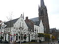
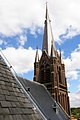
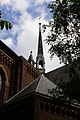
Nederlands: Afbeeldingen van de Roomskatholieke Sint-Laurentiuskerk (Ulvenhout), Dorpstraat 42, 4851 CM Ulvenhout. Gelegen in het centrum van Ulvenhout, behorende tot de gemeente Breda in de provincie Noord-Brabant in het zuiden van Nederland. De Sint-Laurentiuskerk (Ulvenhout) is een rijksmonument
|
This is a category about rijksmonument number 519116
|
church building in Breda, Netherlands  | |||||
| Upload media | |||||
| Instance of | |||||
|---|---|---|---|---|---|
| Part of | |||||
| Location | Ulvenhout, Breda, North Brabant, Netherlands | ||||
| Street address |
| ||||
| Architect |
| ||||
| Heritage designation |
| ||||
| Religion or worldview | |||||
 | |||||
Nederlands: Sint-Laurentiuskerk (Ulvenhout), Ulvenhout, Breda, Breda (gemeente), Noord-Brabant, Nederland
Subcategories
This category has the following 5 subcategories, out of 5 total.
G
Media in category "Sint-Laurentiuskerk (Ulvenhout)"
The following 19 files are in this category, out of 19 total.
-

-

-

-
 Overzicht zandstenen poortje bij de kerk - Ulvenhout - 20346838 - RCE.jpg 1,188 × 1,200; 385 KB
-
 P1030677Ulvenhout.JPG 3,264 × 2,448; 3.12 MB
-
 Sint-Laurentiuskerk (Ulvenhout) P1030020.jpg 4,000 × 2,672; 5.84 MB
-
 Straatbeeld met de Rooms-katholieke Sint Laurentiuskerk - Ulvenhout - 20351363 - RCE.jpg 1,185 × 1,200; 308 KB
-
 T.T RK Kerk st Laurentius Ulvenhout in de Toren.JPG 3,072 × 2,048; 1.21 MB
-
 T.T RK Kerk st Laurentius Ulvenhout Spits.JPG 3,072 × 2,048; 1.2 MB
-
 T.T RK Kerk st Laurentius Ulvenhout Toren vanuit Kraan.JPG 3,072 × 2,048; 1.14 MB
-
 T.T RK Kerk st Laurentius Ulvenhout Toren vanuit Transept.JPG 2,048 × 3,072; 1.1 MB
-
 T.T RK Kerk st Laurentius Ulvenhout Vieringtoren vanuit Toren.JPG 3,072 × 2,048; 1.35 MB
-
 T.T RK Kerk st Laurentius Ulvenhout Vieringtoren.JPG 2,048 × 3,072; 1.09 MB
-
 T.T RK Kerk Ulvenhout.JPG 1,200 × 800; 311 KB
-
 T.T Zandstenen Poort tussen RK Kerk en Pastorie st Laurentius Ulvenhout.JPG 3,072 × 2,048; 1.35 MB
-
 T.T Zandstenen Poortje tussen RK Kerk en Pastorie Ulvenhout Detail.JPG 2,048 × 3,072; 1.28 MB
-
 Toren kerk Ulvenhout P1160474.jpg 4,000 × 2,672; 5.6 MB
-
 Toren kerk Ulvenhout P1160475.jpg 2,672 × 4,000; 5.59 MB
-
 Ulvenhout Sint-Laurentiuskerk.jpg 2,972 × 4,335; 9.36 MB


_P1030020.jpg)


