Category:Sint-Vedastuskerk (Reningelst)
| Object location | | View all coordinates using: OpenStreetMap |
|---|
|
This is a category about Beschermd erfgoed number 14352
|
|
This is a category about onroerend erfgoed number 31375
|
church in Reningelst, Belgium  | |||||
| Upload media | |||||
| Instance of | |||||
|---|---|---|---|---|---|
| Dedicated to | |||||
| Location | Reningelst, Poperinge, Arrondissement of Ypres, West Flanders, Flemish Region, Belgium | ||||
| Diocese | |||||
 | |||||
Subcategories
This category has the following 2 subcategories, out of 2 total.
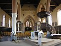
Media in category "Sint-Vedastuskerk (Reningelst)"
The following 16 files are in this category, out of 16 total.
-

-
 Poperinge Reningelstplein 4A - 129676 - onroerenderfgoed.jpg 640 × 480; 68 KB
-
 Poperinge Reningelstplein 4A - 129677 - onroerenderfgoed.jpg 640 × 480; 83 KB
-
 Poperinge Reningelstplein 4A - 129678 - onroerenderfgoed.jpg 640 × 480; 86 KB
-
 Poperinge Reningelstplein 4A - 129679 - onroerenderfgoed.jpg 640 × 480; 79 KB
-
 Poperinge Reningelstplein 4A - 129680 - onroerenderfgoed.jpg 480 × 640; 79 KB
-
 Poperinge Reningelstplein 4A - 129681 - onroerenderfgoed.jpg 640 × 480; 73 KB
-
 Poperinge Reningelstplein 4A - 240259 - onroerenderfgoed.jpg 1,500 × 1,125; 440 KB
-
 Reningelst - Sint-Vedastuskerk 1.jpg 2,304 × 1,728; 1.68 MB
-
 Reningelst - Sint-Vedastuskerk 2.jpg 2,304 × 1,728; 1.77 MB
-
 Reningelst Kerk op het Reningelstplein - 240258 - onroerenderfgoed.jpg 1,500 × 1,125; 369 KB
-
 Reninghelst Churchyard Extension-0947.JPG 1,811 × 2,415; 3.65 MB
-
 Sint - Vedastuskerk te Reningelst.jpg 3,888 × 2,592; 4.97 MB
-
 Sint-Vedastuskerk.JPG 1,811 × 1,944; 2.94 MB
-
 Vitail de Reningelst 2.jpg 4,032 × 3,024; 3.4 MB
-
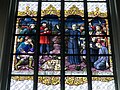 Vitrail de Reningelst 1.jpg 4,032 × 3,024; 3.31 MB


