Category:Sint-Victorkerk (Waddinxveen)
| Object location | | View all coordinates using: OpenStreetMap |
|---|
|
This is a category about a municipal monument in Waddinxveen with number 17 |
|
This is a category about a municipal monument in Waddinxveen with number 18 |
|
This is a category about a municipal monument in Waddinxveen with number 19 |
church building in Waddinxveen, Netherlands  | |||||
| Upload media | |||||
| Instance of | |||||
|---|---|---|---|---|---|
| Location | Waddinxveen, South Holland, Netherlands | ||||
| Street address |
| ||||
| Architect | |||||
| Inception |
| ||||
| Religion or worldview | |||||
 | |||||
Nederlands: De Sint-Victorkerk, de pastorie en de begraafplaats zijn allen Gemeentelijke monumenten
| Address |
|
Subcategories
This category has the following 3 subcategories, out of 3 total.
Media in category "Sint-Victorkerk (Waddinxveen)"
The following 40 files are in this category, out of 40 total.
-
 Exterieur UITVERGROTING VAN KRUIS - Waddinxveen - 20292555 - RCE.jpg 1,200 × 882; 228 KB
-

-
 INTERIEUR, KOOR, GLAS IN LOODRAMEN - Waddinxveen - 20276940 - RCE.jpg 957 × 1,200; 208 KB
-
 Interieur, kruisbeeld - Waddinxveen - 20378545 - RCE.jpg 1,192 × 1,200; 92 KB
-
 Interieur, kruisbeeld - Waddinxveen - 20378546 - RCE.jpg 1,195 × 1,200; 150 KB
-
 Interieur, kruiswegstatie - Waddinxveen - 20378519 - RCE.jpg 1,191 × 1,200; 239 KB
-
 INTERIEUR, MARIAKAPEL, ALTAAR - Waddinxveen - 20276941 - RCE.jpg 1,190 × 1,200; 295 KB
-

-
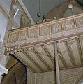 INTERIEUR, ORGEL, BALKON, DETAIL - Waddinxveen - 20276942 - RCE.jpg 1,191 × 1,200; 310 KB
-
 INTERIEUR, OVERZICHT NAAR HET OOSTEN - Waddinxveen - 20276939 - RCE.jpg 956 × 1,200; 221 KB
-
 Interieur, overzicht naar het oosten - Waddinxveen - 20378512 - RCE.jpg 797 × 1,200; 231 KB
-
 INTERIEUR, OVERZICHT NAAR HET WESTEN - Waddinxveen - 20276938 - RCE.jpg 956 × 1,200; 233 KB
-
 Interieur, overzicht naar het westen - Waddinxveen - 20378513 - RCE.jpg 799 × 1,200; 230 KB
-

-

-
 Interieur, zicht op altaar met retabel - Waddinxveen - 20378518 - RCE.jpg 798 × 1,200; 222 KB
-

-

-
 Overzicht - Waddinxveen - 20248616 - RCE.jpg 1,179 × 1,200; 245 KB
-
 Overzicht - Waddinxveen - 20248617 - RCE.jpg 1,195 × 1,200; 259 KB
-
 Overzicht - Waddinxveen - 20248618 - RCE.jpg 1,188 × 1,200; 241 KB
-
 Overzicht - Waddinxveen - 20248641 - RCE.jpg 1,181 × 1,200; 383 KB
-
 Overzicht met westgevel en omgeving - Waddinxveen - 20378509 - RCE.jpg 1,197 × 1,200; 294 KB
-
 Overzicht van de noordwestgevel - Waddinxveen - 20378510 - RCE.jpg 963 × 1,200; 466 KB
-
 Overzicht van de westgevel met kerktoren - Waddinxveen - 20378511 - RCE.jpg 945 × 1,200; 324 KB
-
 Sint-Victorkerk, Waddinxveen. Interieur.jpg 2,432 × 4,320; 4.62 MB
-
 Sint-Victorkerk, Waddinxveen. Kruisbeeld.jpg 2,432 × 4,320; 4.71 MB
-
 Sint-Victorkerk, Waddinxveen. Raam in de kapel (1).jpg 1,872 × 3,339; 3.81 MB
-
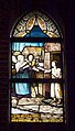 Sint-Victorkerk, Waddinxveen. Raam in de kapel (2).jpg 1,981 × 3,461; 4.5 MB
-
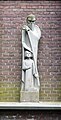 Sint-Victorkerk, Waddinxveen. Sculptuur(1).jpg 1,907 × 3,739; 4.44 MB
-
 Sint-Victorkerk, Waddinxveen. Sculptuur(2).jpg 1,354 × 2,925; 2.61 MB
-
 Sint-Victorkerk, Waddinxveen.jpg 2,432 × 3,461; 5.12 MB
-
 Victorkerk - Waddinxveen-1.JPG 2,592 × 3,872; 2.23 MB
-
 Victorkerk - Waddinxveen-2.JPG 2,592 × 3,872; 2.28 MB
-
 Victorkerk - Waddinxveen-3.JPG 2,592 × 3,872; 2.15 MB
-
 Victorkerk - Waddinxveen-4.JPG 3,872 × 2,592; 2.3 MB
-
 Victorkerk - Waddinxveen-5.JPG 2,592 × 3,872; 2.27 MB
-
 Victorkerk - Waddinxveen-6.JPG 3,872 × 2,592; 2.39 MB
-
 Victorkerk - Waddinxveen-7.JPG 2,592 × 3,872; 2.31 MB
-
 Victorkerk Waddinxveen.JPG 1,536 × 2,048; 653 KB


.jpg)
.jpg)
.jpg)
.jpg)


