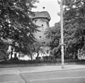
Category:Sint Annamolen, Nijmegen
| Object location | | View all coordinates using: OpenStreetMap |
|---|
windmill in Nijmegen, Netherlands  | |||||
| Upload media | |||||
| Instance of | |||||
|---|---|---|---|---|---|
| Location | Nijmegen, Gelderland, Netherlands | ||||
| Street address |
| ||||
| Has use | |||||
| Heritage designation |
| ||||
| Source of energy | |||||
 | |||||
|
This is a category about rijksmonument number 31199
|
| Address |
|
Media in category "Sint Annamolen, Nijmegen"
The following 21 files are in this category, out of 21 total.
-
 DSC02641 St.Annamolen Nijmegen.JPG 2,304 × 3,072; 2.57 MB
-
 Korenmolen Sint Anna, overzicht - Nijmegen - 20168353 - RCE.jpg 1,200 × 1,184; 408 KB
-
 Korenmolen Sint Anna, overzicht - Nijmegen - 20168354 - RCE.jpg 1,200 × 1,172; 337 KB
-
 Korenmolen Sint Annamolen, in restauratie - Nijmegen - 20168369 - RCE.jpg 1,200 × 1,176; 457 KB
-
 Korenmolen Sint Annamolen, in restauratie - Nijmegen - 20168370 - RCE.jpg 1,200 × 1,172; 385 KB
-
 Korenmolen Sint Annamolen, in restauratie - Nijmegen - 20168371 - RCE.jpg 1,200 × 1,183; 334 KB
-
 Maalzolder 3de.jpeg 5,392 × 1,166; 2.49 MB
-
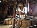 Maalzolder.JPG 3,264 × 2,448; 2.35 MB
-
 Molen H07376.jpg 640 × 212; 155 KB
-
 Molen, Hatertseweg 14, aanzicht - Nijmegen - 20168344 - RCE.jpg 812 × 1,200; 247 KB
-
 Molen, Hatertseweg 14, aanzicht - Nijmegen - 20168345 - RCE.jpg 812 × 1,200; 300 KB
-
 Molenwinkel met Ambachtelijke Broodbakkerij.JPG 4,320 × 943; 1.38 MB
-
 Nijmegen rijksmonument 31199 St.Annamolen, Hatertseweg.JPG 2,304 × 3,072; 2.61 MB
-
 Nijmegen, de Sint Annamolen RM31199 foto6 2017-02-15 12.02.jpg 3,238 × 4,317; 7.88 MB
-
 Sint Anna Molen Voorzijde.JPG 3,264 × 2,448; 3.01 MB
-
 Sint Annamolen, de kap - Nijmegen - 20168321 - RCE.jpg 788 × 1,200; 206 KB
-
 Sint Annamolen, de kap - Nijmegen - 20168322 - RCE.jpg 788 × 1,200; 218 KB
-
 Sint Annamolen, de kap - Nijmegen - 20168323 - RCE.jpg 790 × 1,200; 160 KB
-
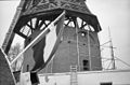 Sint Annamolen, de kap - Nijmegen - 20168324 - RCE.jpg 1,200 × 793; 178 KB
-
 Sint Annamolen, de kap - Nijmegen - 20168325 - RCE.jpg 790 × 1,200; 171 KB
-
 Sint Annamolen, Hazenkamp, Nijmegen.jpg 4,944 × 3,515; 2.37 MB


