Category:Sint Petrus, Vught
| Object location | | View all coordinates using: OpenStreetMap |
|---|
church in Vught, Netherlands  | |||||
| Upload media | |||||
| Instance of | |||||
|---|---|---|---|---|---|
| Named after | |||||
| Dedicated to | |||||
| Location | Vught, North Brabant, Netherlands | ||||
| Street address |
| ||||
| Located on street |
| ||||
| Architectural style | |||||
| Architect | |||||
| Has use |
| ||||
| Has part(s) | |||||
| Heritage designation |
| ||||
| Inception |
| ||||
| Religion or worldview | |||||
 | |||||
Nederlands: Petrus - anno 1884
|
This is a category about rijksmonument number 521327
|
| Address |
|
Media in category "Sint Petrus, Vught"
The following 69 files are in this category, out of 69 total.
-
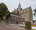 521327 Sint Petrus.jpg 2,500 × 2,112; 4.44 MB
-
 Centrumvught.JPG 1,024 × 768; 346 KB
-
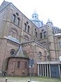
 Exterieur - Vught - 20247822 - RCE.jpg 1,200 × 940; 173 KB
-
 Exterieur - Vught - 20247826 - RCE.jpg 957 × 1,200; 179 KB
-
 Exterieur - Vught - 20247829 - RCE.jpg 788 × 1,200; 183 KB
-
 Gedenkraam Kamp Vught.jpg 1,990 × 3,700; 1.1 MB
-
 Interieur - Vught - 20247825 - RCE.jpg 959 × 1,200; 219 KB
-
 Interieur naar het koor - Vught - 20247823 - RCE.jpg 1,200 × 960; 247 KB
-
 Interieur naar het koor - Vught - 20247827 - RCE.jpg 952 × 1,200; 229 KB
-
 Interieur naar het koor - Vught - 20247828 - RCE.jpg 954 × 1,200; 226 KB
-
 Interieur naar het orgel - Vught - 20247824 - RCE.jpg 960 × 1,200; 240 KB
-
 Interieur, altaar in Jozefkapel - Vught - 20384682 - RCE.jpg 1,200 × 1,200; 201 KB
-

-
 Interieur, gewelven loodrecht naar boven - Vught - 20385336 - RCE.jpg 1,200 × 1,200; 298 KB
-
 Interieur, gewelven vanaf het koor loodrecht naar boven - Vught - 20385335 - RCE.jpg 1,200 × 1,200; 255 KB
-
 Interieur, muurschildering - Vught - 20385311 - RCE.jpg 1,200 × 1,200; 238 KB
-
 Interieur, muurschildering - Vught - 20385312 - RCE.jpg 1,200 × 1,200; 241 KB
-
 Interieur, muurschildering - Vught - 20385313 - RCE.jpg 1,200 × 1,200; 258 KB
-
 Interieur, muurschildering - Vught - 20385320 - RCE.jpg 1,200 × 1,200; 237 KB
-
 Interieur, muurschildering - Vught - 20385323 - RCE.jpg 1,200 × 1,200; 236 KB
-
 Interieur, muurschildering - Vught - 20385329 - RCE.jpg 1,200 × 1,200; 273 KB
-
 Interieur, muurschildering - Vught - 20385365 - RCE.jpg 1,200 × 1,200; 260 KB
-
 Interieur, muurschildering - Vught - 20385372 - RCE.jpg 1,200 × 1,200; 306 KB
-
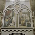
 Interieur, muurschildering- de blijde boodschap - Vught - 20385318 - RCE.jpg 1,200 × 1,200; 239 KB
-
 Interieur, muurschildering- de geboorte van Jezus - Vught - 20385319 - RCE.jpg 1,200 × 1,200; 273 KB
-
 Interieur, muurschildering- de gevangenneming van Jezus - Vught - 20385310 - RCE.jpg 1,200 × 1,200; 234 KB
-
 Interieur, muurschildering- de kruisiging - Vught - 20385316 - RCE.jpg 1,200 × 1,200; 262 KB
-

-

-

-
 Interieur, muurschildering; de Hemelvaart - Vught - 20385308 - RCE.jpg 1,200 × 1,200; 257 KB
-

-
 Interieur, overzicht altaar - Vught - 20385326 - RCE.jpg 1,200 × 1,200; 217 KB
-
 Interieur, overzicht middenschip met orgelgalerij - Vught - 20385341 - RCE.jpg 1,200 × 1,200; 288 KB
-
 Interieur, overzicht middenschip naar het koor - Vught - 20385345 - RCE.jpg 1,200 × 1,200; 282 KB
-
 Interieur, overzicht van transept - Vught - 20385324 - RCE.jpg 1,200 × 1,200; 287 KB
-
 Interieur, preek- en evangeliestoel - Vught - 20385327 - RCE.jpg 1,200 × 1,200; 197 KB
-
 Interieur, preekstoel - Vught - 20385328 - RCE.jpg 1,200 × 1,200; 233 KB
-
 Interieur, zicht op de gewelven, met de koepel - Vught - 20385338 - RCE.jpg 1,200 × 1,200; 300 KB
-

-
 Interieur, zicht op gewelven met schildering - Vught - 20385317 - RCE.jpg 1,200 × 1,200; 311 KB
-
 Kerk Vught (2).JPG 3,008 × 2,000; 1.26 MB
-
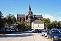
 Overzicht - Vught - 20247830 - RCE.jpg 1,200 × 788; 201 KB
-
 Overzicht kruiskoepelkerk, westgevel met pastorie - Vught - 20384678 - RCE.jpg 1,200 × 1,200; 414 KB
-
 Overzicht kruiskoepelkerk, zuidgevel met ligging - Vught - 20384677 - RCE.jpg 1,200 × 1,200; 259 KB
-
 Overzicht van de driebeukige kerk - Vught - 20415960 - RCE.jpg 1,200 × 880; 143 KB
-
 Overzicht van de oostgevel van kruiskoepelkerk, koor - Vught - 20384676 - RCE.jpg 1,200 × 1,200; 355 KB
-
 Sint Petrus, Vught DSCF3921.JPG 2,112 × 2,816; 2.6 MB
-
 Sint Petrus, Vught DSCF3924.JPG 2,112 × 2,816; 2.74 MB
-
 Sint Petrus, Vught DSCF3925.JPG 2,687 × 2,110; 2.98 MB
-
 Sint Petrus, Vught DSCF3926.JPG 2,112 × 2,816; 2.56 MB
-
 Sint Petrus, Vught DSCF3930.JPG 2,479 × 1,959; 1.94 MB
-
 Sint Petrus, Vught DSCF3931.JPG 2,513 × 2,022; 2.25 MB
-
 Sint Petrus, Vught DSCF3968.JPG 2,603 × 1,972; 2.51 MB
-
 Sint Petrus, Vught DSCF3969.JPG 2,520 × 1,998; 2.59 MB
-
 Sint Petrus, Vught DSCF3970.JPG 2,348 × 1,900; 2.34 MB
-
 Sint Petrus, Vught DSCF3974.JPG 2,112 × 2,816; 2.76 MB
-
 Sint Petrus, Vught DSCF3975.JPG 2,816 × 2,112; 2.82 MB
-
 Sint Petrus, Vught DSCF3976.JPG 2,112 × 2,816; 2.88 MB
-
 Sint Petrus, Vught DSCF3977.JPG 2,666 × 2,068; 2.42 MB
-
 Sint Petrus, Vught DSCF3978.JPG 2,112 × 2,816; 3 MB
-
 Sint Petrus, Vught DSCF3979.JPG 2,112 × 2,816; 2.38 MB
-
 Sint Petrus, Vught DSCF3980.JPG 2,816 × 2,112; 2.44 MB
-
 Sint Petrus, Vught DSCF3981.JPG 2,816 × 2,112; 2.57 MB
-
 Vught - Sint-Petruskerk.jpg 5,667 × 4,416; 18.07 MB
-
 Vught, kerk1 foto4 2011-05-30 13.35.JPG 4,416 × 3,312; 9.64 MB
-
 Zicht op de noord-oostgevel van de kruiskoepelkerk - Vught - 20384679 - RCE.jpg 1,200 × 1,200; 327 KB
-
 Zicht op de noordgevel van kruiskoepelkerk - Vught - 20384681 - RCE.jpg 1,200 × 1,200; 277 KB
-
 Zicht op westgevel van kruiskoepelkerk - Vught - 20384680 - RCE.jpg 1,200 × 1,200; 285 KB


.JPG)


