Category:Sion Mills
English: Sion Mills is a village in County Tyrone, Northern Ireland on the River Mourne. In the 2001 Census it had a population of 2,050 people. It lies within the Strabane District Council area. It is a pleasant tree-lined industrial village and designated conservation area, particularly rich in architectural heritage.
village in United Kingdom  | |||||
| Upload media | |||||
| Instance of | |||||
|---|---|---|---|---|---|
| Location | Northern Ireland | ||||
 | |||||
Subcategories
This category has the following 4 subcategories, out of 4 total.
2
T
Media in category "Sion Mills"
The following 163 files are in this category, out of 163 total.
-
-

-
-
 "The Wee Pool" - geograph.org.uk - 726610.jpg 640 × 419; 102 KB
-
-
 A snipe bog by Dick's Hill wood - geograph.org.uk - 1652022.jpg 640 × 427; 52 KB
-
 A stake for the mill workers ferry - geograph.org.uk - 1651521.jpg 640 × 428; 70 KB
-
 A5 Melmount Road, Sion Mills - geograph.org.uk - 4241448.jpg 640 × 480; 159 KB
-
 Albert Place, Sion Mills - geograph.org.uk - 1076433.jpg 640 × 267; 28 KB
-
 Alexander Place or "The Front Row" - geograph.org.uk - 1320092.jpg 640 × 427; 83 KB
-
 Alexandria Place, Sion Mills - geograph.org.uk - 1076505.jpg 640 × 479; 57 KB
-
 Ambrose Ricardo tablet - geograph.org.uk - 4241510.jpg 640 × 481; 178 KB
-
 Approaching Sion Mills - geograph.org.uk - 4325544.jpg 640 × 480; 151 KB
-
 B72 Liskey Road - geograph.org.uk - 1313779.jpg 640 × 479; 59 KB
-
 Bearney Footbridge, Sion Mills - geograph.org.uk - 83803.jpg 640 × 480; 104 KB
-
 Big John's Bar, Sion Mills - geograph.org.uk - 1075801.jpg 640 × 479; 59 KB
-
 Blearney Glebe - geograph.org.uk - 3063443.jpg 640 × 480; 47 KB
-
 BM3230, Sion Mills PE School - geograph.org.uk - 2023715.jpg 1,920 × 2,560; 1.85 MB
-
 Bus Stop, Sion Mills - geograph.org.uk - 1076504.jpg 640 × 479; 99 KB
-
 Carrigullion Townland - geograph.org.uk - 1313776.jpg 640 × 479; 61 KB
-
 Carrigullion Townland - geograph.org.uk - 1313778.jpg 640 × 479; 54 KB
-
 Church Hall - geograph.org.uk - 83238.jpg 640 × 479; 147 KB
-
 Church Hall, Sion Mills - geograph.org.uk - 4241469.jpg 640 × 480; 172 KB
-
 Church Hall, Sion Mills - geograph.org.uk - 4241558.jpg 640 × 480; 170 KB
-
 Church Information Board, Sion Mills - geograph.org.uk - 4241402.jpg 480 × 640; 183 KB
-
 Church of the Good Shepherd Rectors - geograph.org.uk - 4241523.jpg 2,647 × 1,482; 492 KB
-

-
 Church of the Good Shepherd, Sion Mills - geograph.org.uk - 4241475.jpg 640 × 480; 156 KB
-
 Church Square, Sion Mills - geograph.org.uk - 5502795.jpg 640 × 480; 159 KB
-
 Clock tower, Sion Mills - geograph.org.uk - 4241435.jpg 640 × 480; 128 KB
-
 Cog wheels, Sion Mills - geograph.org.uk - 1076485.jpg 640 × 479; 67 KB
-
 Cog wheels, Sion Mills - geograph.org.uk - 3063455.jpg 1,920 × 2,560; 1.78 MB
-
 Conthem Road, Bearney Glebe - geograph.org.uk - 4360502.jpg 640 × 480; 156 KB
-
 Downstream view from the Lade bridge - geograph.org.uk - 726642.jpg 640 × 405; 91 KB
-
 Drum Road - geograph.org.uk - 4452579.jpg 640 × 480; 138 KB
-
 Drum Road, Drumnaboy - geograph.org.uk - 4452467.jpg 640 × 480; 148 KB
-
 Drum Road, Stragullin - geograph.org.uk - 4452569.jpg 640 × 480; 149 KB
-
 Drum, Church of the Good Shepherd - geograph.org.uk - 4241515.jpg 640 × 480; 137 KB
-

-
-
 Factory worker sculpture, Sion Mills - geograph.org.uk - 4241570.jpg 480 × 640; 175 KB
-
 Farmhouse, Carrigullion - geograph.org.uk - 1313774.jpg 640 × 479; 79 KB
-
 Flax Spinner sculpture, Sion Mills - geograph.org.uk - 4241569.jpg 640 × 480; 206 KB
-
 Flower Junction, Sion Mills - geograph.org.uk - 4241456.jpg 640 × 480; 162 KB
-
 Footbridge across the Mourne - geograph.org.uk - 3063422.jpg 1,920 × 2,560; 2.07 MB
-
 Footbridge at Sion Mills - geograph.org.uk - 3063445.jpg 640 × 480; 69 KB
-
 Former primary school, Sion Mills - geograph.org.uk - 5502812.jpg 640 × 480; 170 KB
-
 Former Telephone Exchange, Sion Mills - geograph.org.uk - 2023726.jpg 1,920 × 2,560; 824 KB
-
 Former telephone exchange, Sion Mills - geograph.org.uk - 5502810.jpg 640 × 480; 142 KB
-
 Gate House Sion Mills - geograph.org.uk - 83253.jpg 640 × 479; 132 KB
-
 Gatehouse at Sion House, County Tyrone.png 922 × 684; 890 KB
-

-
 Heading to Omagh - geograph.org.uk - 108240.jpg 640 × 479; 113 KB
-
-

-
 Historic building, Sion Mills - geograph.org.uk - 5502820.jpg 640 × 482; 148 KB
-
 House at Ballyfatten - geograph.org.uk - 140153.jpg 640 × 479; 130 KB
-
 Houses, Sion Mills - geograph.org.uk - 1075825.jpg 640 × 479; 80 KB
-
 Icy Conditions, Sion Mills - geograph.org.uk - 1076498.jpg 640 × 479; 94 KB
-

-

-
 Inscribed stone, St Theresa's Church - geograph.org.uk - 5502823.jpg 640 × 480; 169 KB
-
 Interior, Church Hall, Sion Mills - geograph.org.uk - 4241472.jpg 640 × 480; 171 KB
-
-

-
 J D Motors, Sion Mills - geograph.org.uk - 1075810.jpg 640 × 479; 51 KB
-
 Joe's Takeaway, Sion Mills - geograph.org.uk - 994425.jpg 640 × 480; 52 KB
-
 Linen Green, Sion Mills - geograph.org.uk - 654178.jpg 640 × 290; 28 KB
-
 Liskey Road - geograph.org.uk - 3063429.jpg 640 × 480; 63 KB
-
 Liskey Road - geograph.org.uk - 3063432.jpg 640 × 480; 44 KB
-
 Liskey Road - Old Strabane Road - geograph.org.uk - 1313782.jpg 640 × 479; 63 KB
-
 Liskey Road, Bearney Glebe - geograph.org.uk - 4360506.jpg 640 × 480; 157 KB
-

-

-
 Lych Gate, Sion Mills - geograph.org.uk - 1076500.jpg 640 × 479; 62 KB
-
 Lynch gate, St Saviors Church Hall - geograph.org.uk - 5502790.jpg 640 × 480; 185 KB
-
 Main Street, Sion Mills - geograph.org.uk - 1320039.jpg 640 × 478; 60 KB
-
 Main Street, Sion Mills - geograph.org.uk - 5502839.jpg 640 × 480; 172 KB
-
 Manhole covers along Melmount Road - geograph.org.uk - 5502834.jpg 640 × 480; 146 KB
-
 Marshall's, Sion Mills - geograph.org.uk - 1075741.jpg 640 × 479; 53 KB
-
 McCafferty's, Sion Mills - geograph.org.uk - 5502781.jpg 640 × 480; 182 KB
-
 Melmount Road, Sion Mills - geograph.org.uk - 1076436.jpg 640 × 479; 59 KB
-
 Melmount Road, Sion Mills - geograph.org.uk - 3215348.jpg 1,024 × 711; 189 KB
-
 Melmount Road, Sion Mills - geograph.org.uk - 4241392.jpg 640 × 480; 167 KB
-
 Melmount Road, Sion Mills - geograph.org.uk - 5502794.jpg 640 × 480; 161 KB
-
 Mill Avenue, Sion Mills - geograph.org.uk - 1076499.jpg 640 × 479; 79 KB
-
 Old farm building - geograph.org.uk - 141936.jpg 640 × 478; 124 KB
-
 Out for a stroll, Sion Mills - geograph.org.uk - 3063479.jpg 640 × 480; 79 KB
-
 P G McGillion, Sion Mills - geograph.org.uk - 1076435.jpg 640 × 479; 51 KB
-
 Parochial Hall ,Sion Mills - geograph.org.uk - 1075813.jpg 640 × 479; 49 KB
-
 Path and footbridge to Sion Mills - geograph.org.uk - 3063428.jpg 1,920 × 2,560; 2.43 MB
-
 Path, Mourneside River Walk - geograph.org.uk - 3063417.jpg 640 × 480; 61 KB
-
 Paul Logue Motors, Sion Mills - geograph.org.uk - 1075724.jpg 640 × 479; 58 KB
-
 Plaque dated 1866, Sion Mills - geograph.org.uk - 5502802.jpg 640 × 480; 168 KB
-
 Plaque, Sion Mills School - geograph.org.uk - 2023721.jpg 640 × 480; 53 KB
-

-

-
 Presbyterian Church, Sion Mills - geograph.org.uk - 4241394.jpg 480 × 640; 171 KB
-
 Presbyterian Church, Sion Mills - geograph.org.uk - 5502805.jpg 640 × 480; 174 KB
-
 Primrose Park, Sion Mills - geograph.org.uk - 1075800.jpg 640 × 263; 31 KB
-
 RC Church, Sion Mills - geograph.org.uk - 4241442.jpg 640 × 480; 184 KB
-

-
 Recretation Club - geograph.org.uk - 83241.jpg 640 × 479; 145 KB
-
 Restaurant 1861 and Museum, Sion Mills - geograph.org.uk - 5502829.jpg 640 × 481; 171 KB
-
 Resting wheels by the "Cot" - geograph.org.uk - 1651509.jpg 640 × 427; 84 KB
-
 River Mourne - geograph.org.uk - 1076479.jpg 640 × 479; 82 KB
-
 River walk, Sion Mills - geograph.org.uk - 1076491.jpg 640 × 291; 48 KB
-
 Road at Primrose Park, Sion Mills - geograph.org.uk - 1075814.jpg 640 × 479; 51 KB
-
 Road near Ballyfatten - geograph.org.uk - 140154.jpg 640 × 479; 86 KB
-
 Ruined factory, Sion Mills - geograph.org.uk - 4379760.jpg 640 × 482; 234 KB
-
 Rural scene south of Strabane - geograph.org.uk - 1508658.jpg 640 × 387; 46 KB
-
 Salmon anglers fish the"Gravenue" on the river Mourne - geograph.org.uk - 6213577.jpg 1,600 × 1,068; 1.44 MB
-

-
 Scissor Sisters, Sion Mills - geograph.org.uk - 1075841.jpg 640 × 479; 54 KB
-
 Seat along the Mourne River - geograph.org.uk - 3063450.jpg 640 × 480; 89 KB
-
 Seat at the Mourne River, Sion Mills - geograph.org.uk - 3063476.jpg 640 × 480; 87 KB
-
 Security Fence, Sion Mills - geograph.org.uk - 1076476.jpg 640 × 479; 54 KB
-
 Seein, Sion Mills - geograph.org.uk - 191342.jpg 640 × 479; 53 KB
-
 Silver Moon, Sion Mills - geograph.org.uk - 1076434.jpg 640 × 479; 73 KB
-
 Sion Mills - geograph.org.uk - 1076502.jpg 640 × 267; 40 KB
-
 Sion Mills - geograph.org.uk - 191348.jpg 640 × 479; 57 KB
-
 Sion Mills Branch Library - geograph.org.uk - 1075819.jpg 640 × 479; 66 KB
-
 Sion Mills Decor - Dot's Chippy - geograph.org.uk - 1075723.jpg 640 × 479; 51 KB
-
 Sion Mills Public Elementary School - geograph.org.uk - 4241418.jpg 640 × 480; 193 KB
-
 Sion Mills Public Elementary School - geograph.org.uk - 83247.jpg 640 × 479; 163 KB
-
 Sion Tiles - geograph.org.uk - 1075807.jpg 640 × 479; 47 KB
-

-
-
 Sluice gates to "The Lade" - geograph.org.uk - 1651487.jpg 640 × 426; 112 KB
-
 Sluice gates, Sion Mills - geograph.org.uk - 1076483.jpg 479 × 640; 155 KB
-
 Sluice gates, Sion Mills - geograph.org.uk - 1076487.jpg 640 × 479; 78 KB
-
 Spar, Sion Mills - geograph.org.uk - 1076437.jpg 640 × 479; 55 KB
-
 St Saviors Church Hall and Lynch gate - geograph.org.uk - 4241565.jpg 640 × 480; 175 KB
-
 St Saviors Church Hall, Sion Mills - geograph.org.uk - 5502786.jpg 640 × 480; 176 KB
-
 St Theresa's RC Church, Sion Mills - geograph.org.uk - 5502816.jpg 640 × 482; 135 KB
-
 Stables Zion House - geograph.org.uk - 83257.jpg 640 × 479; 105 KB
-
 Steps to village hall, Sion Mills - geograph.org.uk - 5502800.jpg 640 × 480; 158 KB
-
 Stragullin Townland - geograph.org.uk - 4452568.jpg 640 × 480; 135 KB
-
 Stragullin Townland - geograph.org.uk - 4452575.jpg 640 × 480; 149 KB
-
 Stragullin Townland - geograph.org.uk - 4452583.jpg 640 × 480; 163 KB
-
 Stragullin Townland - geograph.org.uk - 4452585.jpg 640 × 480; 141 KB
-
 Swinging Bridge, Sion Mills - geograph.org.uk - 1076477.jpg 479 × 640; 106 KB
-
 Swinging Bridge, Sion Mills - geograph.org.uk - 1076478.jpg 640 × 479; 92 KB
-
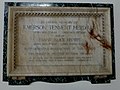 Tablet, Emerson Tennent Herdman - geograph.org.uk - 4241493.jpg 640 × 481; 176 KB
-
 The Brae Field football pitch - geograph.org.uk - 1323595.jpg 640 × 427; 56 KB
-
 The Church Hall at Sion Mills - geograph.org.uk - 1506581.jpg 640 × 555; 61 KB
-
 The Gravenue on the Mourne at Sion Mills - geograph.org.uk - 740818.jpg 640 × 469; 101 KB
-

-
 The Lodge, Sion Mills - geograph.org.uk - 1075743.jpg 640 × 479; 70 KB
-
 The Mourne at Sion Mills - geograph.org.uk - 3063472.jpg 640 × 480; 61 KB
-
 The Mourne Valley north of Sion Mill - geograph.org.uk - 1508619.jpg 640 × 480; 29 KB
-

-
 The Salmon Leap at Sion Mills - geograph.org.uk - 1651480.jpg 640 × 427; 83 KB
-

-
 The Square, Sion Mills - geograph.org.uk - 1075817.jpg 640 × 479; 54 KB
-
 The Square, Sion Mills - geograph.org.uk - 1075823.jpg 640 × 479; 74 KB
-
 The Stables Restaurant, Sion Mills - geograph.org.uk - 4241430.jpg 640 × 480; 162 KB
-
 The Swingin' Bridge at Sion Mills - geograph.org.uk - 740489.jpg 640 × 421; 82 KB
-
 The Village Green, Sion Mills - geograph.org.uk - 4241379.jpg 640 × 480; 163 KB
-

-

-

-


_-_geograph.org.uk_-_4241561.jpg)


_-_geograph.org.uk_-_4241479.jpg)
_-_geograph.org.uk_-_4241480.jpg)


