Category:Skendleby
English: Skendleby is a village located near to the A158 and lies north east of the town of Spilsby in Lincolnshire. The village has a reasonably large number of houses and a pub called the Blacksmith's Arms. It is served by a Translinc bus service which runs through the village daily.
human settlement in United Kingdom  kościół w Skendleby | |||||
| Upload media | |||||
| Instance of | |||||
|---|---|---|---|---|---|
| Location | East Lindsey, Lincolnshire, East Midlands, England | ||||
| Population |
| ||||
 | |||||
Media in category "Skendleby"
The following 105 files are in this category, out of 105 total.
-

-
 Blacksmiths Arms, Skendleby - geograph.org.uk - 2434843.jpg 640 × 427; 112 KB
-

-

-

-

-

-
 Dalby Hall Estate, aerial 2014 - geograph.org.uk - 3881718.jpg 640 × 427; 48 KB
-
 Dalby Hall estate, aerial 2014 - geograph.org.uk - 4055472.jpg 640 × 427; 49 KB
-
 Dalby, aerial 2016 - geograph.org.uk - 5229922.jpg 427 × 640; 56 KB
-
 Dalby, aerial 2016 - geograph.org.uk - 5229936.jpg 520 × 640; 70 KB
-
 Dalby, aerial 2018 - geograph.org.uk - 5770144.jpg 800 × 533; 83 KB
-
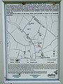 Defra map at Skendleby - geograph.org.uk - 554019.jpg 480 × 640; 80 KB
-

-

-
 Earthworks at Skendleby, aerial 2018 - geograph.org.uk - 5964857.jpg 800 × 533; 126 KB
-

-
 Fields around Skendleby, aerial 2017 - geograph.org.uk - 5467284.jpg 640 × 427; 62 KB
-
 Footpath crosses a footbridge - geograph.org.uk - 3436857.jpg 1,168 × 1,828; 2.81 MB
-
 Fordington, aerial 2019 - geograph.org.uk - 6190620.jpg 640 × 427; 65 KB
-

-

-

-
 Horse and pony at Thorpe Farm - geograph.org.uk - 554488.jpg 640 × 480; 110 KB
-
 Horses and pony at Thorpe Farm - geograph.org.uk - 554483.jpg 640 × 480; 127 KB
-
-
 Lane near Fordington - geograph.org.uk - 2694622.jpg 1,280 × 960; 440 KB
-

-
 Manor Farm from Fordington Wood - geograph.org.uk - 3861871.jpg 640 × 427; 76 KB
-

-
 Multicoloured horses at Thorpe Farm - geograph.org.uk - 4007998.jpg 640 × 427; 88 KB
-
 North of Skendleby, aerial 2017 - geograph.org.uk - 5326183.jpg 640 × 427; 50 KB
-
 Old Dutch barn - geograph.org.uk - 4007846.jpg 640 × 427; 92 KB
-

-
 Old Toll House - geograph.org.uk - 4007834.jpg 640 × 427; 95 KB
-
 Piebald and waterhole - geograph.org.uk - 4007988.jpg 640 × 427; 90 KB
-

-

-

-
 Road to Claxby St Andrew - geograph.org.uk - 3436866.jpg 2,256 × 1,504; 2.05 MB
-
 Skendleby cross roads on A1028 south - geograph.org.uk - 3004288.jpg 640 × 411; 59 KB
-
 Skendleby from the footpath to Dalby - geograph.org.uk - 4007901.jpg 640 × 427; 68 KB
-
 Skendleby from the footpath to Dalby - geograph.org.uk - 4007912.jpg 640 × 427; 57 KB
-
 Skendleby Hall - geograph.org.uk - 4007890.jpg 640 × 427; 69 KB
-
 Skendleby Psalter - geograph.org.uk - 3861892.jpg 640 × 427; 61 KB
-
 Skendleby Psalter - geograph.org.uk - 3861900.jpg 640 × 427; 75 KB
-
 Skendleby Psalter, aerial 2014 - geograph.org.uk - 3834427.jpg 640 × 427; 35 KB
-

-
 Skendleby Village Hall - geograph.org.uk - 4007877.jpg 640 × 427; 76 KB
-
 Skendleby, aerial 2014 - geograph.org.uk - 3834951.jpg 1,024 × 683; 159 KB
-
 Skendleby, aerial 2014 - geograph.org.uk - 3834958.jpg 1,024 × 545; 131 KB
-
 Skendleby, aerial 2018 - geograph.org.uk - 5661394.jpg 800 × 533; 77 KB
-

-
 Stile and footpath near Skendleby - geograph.org.uk - 3434014.jpg 2,256 × 1,504; 3.24 MB
-
 Stile at Thorpe Farm, Skendleby - geograph.org.uk - 554383.jpg 480 × 640; 98 KB
-
 Stile at Thorpe Farm, Skendleby - geograph.org.uk - 554394.jpg 640 × 480; 129 KB
-
 Stile near Thorpe Farm, Skendleby - geograph.org.uk - 554346.jpg 640 × 480; 133 KB
-
 Sunlit sycamore tree - geograph.org.uk - 4008170.jpg 640 × 427; 86 KB
-

-
 The parting of the crop - geograph.org.uk - 4007770.jpg 427 × 640; 68 KB
-
 The parting of the crop - geograph.org.uk - 4007772.jpg 640 × 427; 70 KB
-
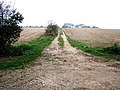
 Track north to Rigge Wood - geograph.org.uk - 3436887.jpg 2,256 × 1,504; 2.63 MB
-

-

-

-
 View to Welton High Wood - geograph.org.uk - 2675258.jpg 1,280 × 960; 558 KB
-
 Village Hall, Skendleby - geograph.org.uk - 554217.jpg 640 × 480; 95 KB
-
 What^ No boardwalk^ - geograph.org.uk - 4007958.jpg 640 × 427; 88 KB
-

-
 A158 near Scremby Grange - geograph.org.uk - 1151650.jpg 640 × 480; 118 KB
-

-
 Big Hedgerow - geograph.org.uk - 235239.jpg 640 × 480; 128 KB
-
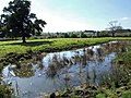
 Brook at Skendleby - geograph.org.uk - 554226.jpg 640 × 480; 163 KB
-
 Farm entrance - geograph.org.uk - 483026.jpg 640 × 482; 172 KB
-
 Farm track at Claxby St Andrew - geograph.org.uk - 595833.jpg 640 × 480; 96 KB
-
 Farm track at Claxby St Andrew - geograph.org.uk - 595839.jpg 640 × 480; 113 KB
-
 Farm track at Claxby St Andrew - geograph.org.uk - 595843.jpg 640 × 480; 107 KB
-

-
 Footpath at Skendleby - geograph.org.uk - 554008.jpg 640 × 480; 147 KB
-
 Footpath at Skendleby - geograph.org.uk - 554028.jpg 640 × 480; 114 KB
-
 Footpath at Skendleby - geograph.org.uk - 554224.jpg 640 × 480; 115 KB
-
 Footpath at Skendleby - geograph.org.uk - 554229.jpg 480 × 640; 65 KB
-
 Footpath from Skendleby to Dalby - geograph.org.uk - 554366.jpg 640 × 480; 168 KB
-
 Footpath from Skendleby to Dalby - geograph.org.uk - 554371.jpg 480 × 640; 131 KB
-

-
 Four Ways - geograph.org.uk - 235235.jpg 640 × 480; 117 KB
-
 Group of horses at Thorpe Farm - geograph.org.uk - 554482.jpg 640 × 480; 138 KB
-
 Lane at Claxby St Andrew - geograph.org.uk - 595854.jpg 640 × 480; 83 KB
-

-
 Lane to Claxby - geograph.org.uk - 231873.jpg 640 × 480; 85 KB
-
 Lane to Scremby - geograph.org.uk - 231870.jpg 640 × 480; 82 KB
-
 Pond at Thorpe Farm, Skendleby - geograph.org.uk - 554415.jpg 640 × 480; 101 KB
-
 Pond at Thorpe Farm, Skendleby - geograph.org.uk - 554419.jpg 640 × 480; 87 KB
-
 Pony at Thorpe Farm - geograph.org.uk - 554492.jpg 480 × 640; 114 KB
-
 Power pole at Skendleby - geograph.org.uk - 554343.jpg 640 × 480; 48 KB
-

-
 Roman Road - geograph.org.uk - 231871.jpg 640 × 480; 80 KB
-
-

-
 Teasel by the footpath at Skendleby - geograph.org.uk - 554221.jpg 640 × 480; 59 KB
-
 Teasels by the footpath at Skendleby - geograph.org.uk - 554219.jpg 640 × 480; 163 KB
-
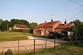
 Thorpe Farm near Skendleby - geograph.org.uk - 551524.jpg 640 × 480; 89 KB
-
 Thorpe Farm, Skendleby - geograph.org.uk - 551308.jpg 640 × 480; 112 KB
-
 Water on the Hill - geograph.org.uk - 235238.jpg 640 × 480; 124 KB
-
 Welton High Wood - geograph.org.uk - 231872.jpg 640 × 480; 100 KB


_-_geograph.org.uk_-_5985543.jpg)
_-_geograph.org.uk_-_5985545.jpg)


_-_geograph.org.uk_-_5985530.jpg)


_-_geograph.org.uk_-_5965077.jpg)
_-_geograph.org.uk_-_5965071.jpg)


