Category:Sommerfeld (Kremmen)
| Object location | | View all coordinates using: OpenStreetMap |
|---|
village in Brandenburg state, Germany  La chiesa | |||||
| Upload media | |||||
| Instance of |
| ||||
|---|---|---|---|---|---|
| Location |
| ||||
| Located in or next to body of water | |||||
| Has part(s) | |||||
| Population |
| ||||
| Elevation above sea level |
| ||||
 | |||||
English: The village Sommerfeld is part of Kremmen municipality, Oberhavel district, Brandenburg state, Germany
Deutsch: Das Dorf Sommerfeld gehört zur Stadt Kremmen, Landkreis Oberhavel, Land Brandenburg, Deutschland
Français : Le village de Sommerfeld fait partie de la ville de Kremmen, arrondissement Haute-Havel, état fédéral de Brandebourg, Allemagne
Subcategories
This category has the following 5 subcategories, out of 5 total.
Media in category "Sommerfeld (Kremmen)"
The following 11 files are in this category, out of 11 total.
-
 Das Sommerfeld bei Kremmen, Foto 1 Gottfried Grafe 2010.jpg 3,508 × 2,362; 3.72 MB
-
 Das Sommerfeld bei Kremmen, Foto 2 Gottfried Grafe 2010.jpg 3,264 × 2,448; 3.41 MB
-
 Einwohnerentwicklung von Sommerfeld Kremmen.svg 808 × 372; 36 KB
-
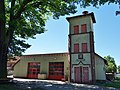 Feuerwache Sommerfeld 2017.jpg 4,864 × 3,648; 7.47 MB
-
 Gefallenendenkmal Sommerfeld 2017.jpg 3,648 × 4,864; 6.33 MB
-
 Kremmen.png 4,036 × 3,050; 14.1 MB
-
 Naturdenkmal Rosskastanie Landkreis Oberhavel Brandenburg 02.jpg 2,000 × 3,000; 5.08 MB
-
 Sommerfeld 1840 Urmesstischblatt.jpg 990 × 660; 617 KB
-
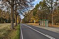 Sommerfeld Bushaltestelle asv2023-11.jpg 4,080 × 2,720; 11.91 MB
-
 Sommerfeld center 2017.jpg 7,431 × 3,308; 8.68 MB
-
 Sommerfeld Hotel und Spa asv2023-11.jpg 4,080 × 2,295; 6.02 MB


