Category:South Ferry Basin
| Object location | | View all coordinates using: OpenStreetMap |
|---|
Main Wikipedia article: South Ferry Basin.
tidal basin on the river Mersey and part of the Port of Liverpool, in England | |||||
| Upload media | |||||
| Instance of |
| ||||
|---|---|---|---|---|---|
| Part of | |||||
| Location | Liverpool, Merseyside, North West England, England | ||||
 | |||||
Subcategories
This category has only the following subcategory.
Media in category "South Ferry Basin"
The following 10 files are in this category, out of 10 total.
-
 Crossed anchors at South Ferry Basin.jpg 5,038 × 3,158; 7.91 MB
-
 Dkbkpl29.jpg 1,165 × 705; 137 KB
-
 Quebec Quay, Liverpool (geograph 3059077).jpg 3,296 × 2,472; 1.86 MB
-
 Riverside housing, Liverpool Marina (geograph 4560780).jpg 1,024 × 681; 153 KB
-
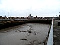 Silted-up South Ferry Basin (geograph 3814985).jpg 4,320 × 3,240; 2.98 MB
-
 Slipway of South Ferry Basin.jpg 3,456 × 5,184; 10.38 MB
-
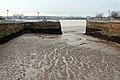 South Ferry Basin 1.jpg 5,184 × 3,456; 11.09 MB
-
 South Ferry Basin 2.jpg 4,851 × 3,163; 7.71 MB
-
 South Ferry Basin, Liverpool.JPG 4,608 × 3,456; 3.72 MB
-
 The old fishing boat dock from Coburg Wharf (geograph 2090710).jpg 1,600 × 1,198; 319 KB


.jpg)
.jpg)
.jpg)


.jpg)