Category:Southill, Bedfordshire
village and civil parish in Bedfordshire, UK .jpg) | |||||
| Upload media | |||||
| Instance of | |||||
|---|---|---|---|---|---|
| Location | Central Bedfordshire, Bedfordshire, East of England, England | ||||
 | |||||
Subcategories
This category has the following 5 subcategories, out of 5 total.
I
- Ireland, Bedfordshire (2 F)
S
- Southill Park (2 F)
- Southill railway station (2 F)
- Stanford, Bedfordshire (4 F)
Media in category "Southill, Bedfordshire"
The following 200 files are in this category, out of 220 total.
(previous page) (next page)-
 A farm track into Broom - geograph.org.uk - 2936415.jpg 1,142 × 857; 276 KB
-
 A footpath across farmland - geograph.org.uk - 2939470.jpg 1,142 × 857; 288 KB
-
 A600 near Rowney Warren Wood - geograph.org.uk - 6221944.jpg 1,024 × 683; 273 KB
-
 All part of the Pub - geograph.org.uk - 5813940.jpg 4,916 × 3,456; 5.51 MB
-
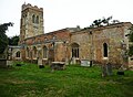 All Saints Church, Southill - geograph.org.uk - 6197140.jpg 2,000 × 1,462; 833 KB
-
 And they are off^ - geograph.org.uk - 2477863.jpg 768 × 1,024; 240 KB
-
 B658 towards Shefford - geograph.org.uk - 4630360.jpg 640 × 480; 84 KB
-
 B658 towards Stanford - geograph.org.uk - 4626418.jpg 640 × 480; 56 KB
-
 B658, Stanford - geograph.org.uk - 4626445.jpg 640 × 480; 75 KB
-
 Bancroft Avenue, Broom - geograph.org.uk - 5812420.jpg 4,897 × 3,134; 2.59 MB
-
 Bedford Road, Chicksands - geograph.org.uk - 5570305.jpg 2,048 × 1,536; 886 KB
-
 Bell's Wood beyond the railway cutting - geograph.org.uk - 4158480.jpg 1,600 × 1,068; 577 KB
-
 Black Horse, Ireland - geograph.org.uk - 2292137.jpg 640 × 480; 89 KB
-
 Bridge over disused railway - geograph.org.uk - 4506142.jpg 4,320 × 3,240; 6.08 MB
-
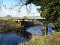 Bridge over former River Ivel Navigation - geograph.org.uk - 4863651.jpg 640 × 480; 196 KB
-
 Bridge over the dismantled Bedford-Hitchin railway - geograph.org.uk - 4158485.jpg 1,600 × 1,067; 675 KB
-
 Bridge over the dismantled railway - geograph.org.uk - 4158484.jpg 1,600 × 1,067; 596 KB
-
 Bridge, Beford-Hitchin railway - geograph.org.uk - 4502827.jpg 4,320 × 3,240; 5.71 MB
-
 Bridleway near to Shuttleworth Agricultural College - geograph.org.uk - 4619339.jpg 4,320 × 3,240; 5.06 MB
-
 Bridleway to Broom - geograph.org.uk - 4688802.jpg 1,066 × 1,600; 747 KB
-
 Bridleway towards Kingshill farm - geograph.org.uk - 4688744.jpg 1,600 × 1,066; 587 KB
-
 Bridleway towards Old Warden - geograph.org.uk - 4688944.jpg 1,600 × 1,066; 374 KB
-
 Broom Farm trig and the field it inhabits - geograph.org.uk - 2936406.jpg 1,142 × 857; 332 KB
-
 Broom Hall - geograph.org.uk - 5812676.jpg 5,033 × 2,669; 1.45 MB
-
 Broom Lake - geograph.org.uk - 3625091.jpg 640 × 407; 93 KB
-
 Bushes by Bedford Road, Shefford - geograph.org.uk - 5570304.jpg 2,048 × 1,536; 1.52 MB
-
 Car park - geograph.org.uk - 4755378.jpg 640 × 480; 112 KB
-
 Car Park Rowney Warren Woods - geograph.org.uk - 2581486.jpg 2,896 × 1,944; 1.59 MB
-
 Casket tomb in the churchyard, Southill - geograph.org.uk - 6197157.jpg 2,000 × 1,500; 965 KB
-
 Cockshoot grove - geograph.org.uk - 3485903.jpg 1,600 × 1,069; 333 KB
-
 Copse by the stream - geograph.org.uk - 4158519.jpg 1,600 × 1,067; 503 KB
-
 Cottage - geograph.org.uk - 2129909.jpg 768 × 1,024; 306 KB
-
 Cottages on Mill Road, Stanford - geograph.org.uk - 2935281.jpg 1,142 × 857; 331 KB
-
 Cottages, High Street, Southill - geograph.org.uk - 4863174.jpg 640 × 428; 111 KB
-
 Course of the Bedford to Hitchin railway - geograph.org.uk - 4158488.jpg 1,200 × 1,600; 738 KB
-
 Crop field near Ireland - geograph.org.uk - 4629161.jpg 640 × 480; 83 KB
-
 Cyclists and observer. - geograph.org.uk - 2477867.jpg 768 × 1,024; 237 KB
-
 Deadman's Cross - geograph.org.uk - 4867172.jpg 2,592 × 1,944; 1.31 MB
-

-
 Demarcation Fence - Mountain Bikers Area Rowney Warren Woods - geograph.org.uk - 2581461.jpg 1,944 × 2,896; 1.21 MB
-
 Derelict corrugated hut - geograph.org.uk - 3485834.jpg 1,600 × 1,068; 613 KB
-
 Derelict farm buildings just off Mill Road - geograph.org.uk - 2935287.jpg 1,142 × 857; 398 KB
-
 Entrance to car park - geograph.org.uk - 4755375.jpg 640 × 480; 114 KB
-
 Entrance to Ireland and Black Horse pub - geograph.org.uk - 4158482.jpg 1,600 × 1,068; 566 KB
-
 Estate houses near the end of School Lane, Southill - geograph.org.uk - 6197174.jpg 2,000 × 1,362; 829 KB
-
 Estate houses, School Lane, Southill - geograph.org.uk - 6197161.jpg 2,000 × 1,500; 789 KB
-
 Farm building, Gracious Farm, Southill - geograph.org.uk - 6197177.jpg 2,000 × 1,428; 805 KB
-
 Farm Track - geograph.org.uk - 4158478.jpg 1,600 × 1,068; 535 KB
-
 Farm track - geograph.org.uk - 4863080.jpg 640 × 480; 149 KB
-
 Farm track east of Southill - geograph.org.uk - 4626426.jpg 640 × 480; 83 KB
-
 Farm track near Broom - geograph.org.uk - 4617006.jpg 640 × 480; 68 KB
-
 Farmland at Stanford - geograph.org.uk - 4867164.jpg 2,592 × 1,944; 1.71 MB
-
 Farmland by the footpath - geograph.org.uk - 4158507.jpg 1,600 × 1,067; 369 KB
-
 Farmland south of Stanford - geograph.org.uk - 4626453.jpg 640 × 480; 71 KB
-
 Farmland towards Beal's Wood - geograph.org.uk - 4629157.jpg 640 × 480; 85 KB
-
 Field alongside Stanford Lane - geograph.org.uk - 6046446.jpg 2,000 × 1,376; 910 KB
-
 Field by Stanford Road - geograph.org.uk - 4688791.jpg 1,600 × 1,066; 453 KB
-
 Field entrance near Southill - geograph.org.uk - 4629162.jpg 640 × 480; 78 KB
-
 Field entrance off Southill Road - geograph.org.uk - 4619072.jpg 640 × 480; 93 KB
-
 Fields southwest of Ireland - geograph.org.uk - 2292143.jpg 640 × 480; 50 KB
-
 Fields, Shuttleworth Estate - geograph.org.uk - 4863089.jpg 640 × 480; 135 KB
-
 Flat farmland near Kingshill Farm - geograph.org.uk - 4630357.jpg 640 × 480; 73 KB
-

-
 Footpath across fields at Stanford - geograph.org.uk - 2936395.jpg 1,142 × 857; 363 KB
-

-
 Footpath into Broom - geograph.org.uk - 4688985.jpg 1,600 × 1,066; 604 KB
-
 Footpath into Shefford - geograph.org.uk - 4158494.jpg 1,600 × 1,068; 637 KB
-
 Footpath near Shuttleworth College - geograph.org.uk - 316412.jpg 640 × 480; 172 KB
-
 Footpath to Broom - geograph.org.uk - 2936400.jpg 808 × 1,077; 360 KB
-
 Footpath to Broom - geograph.org.uk - 4630359.jpg 640 × 480; 115 KB
-
 Footpath to Broom - geograph.org.uk - 4688949.jpg 1,600 × 1,066; 482 KB
-
 Footpath to the B658 - geograph.org.uk - 4688954.jpg 1,600 × 1,066; 499 KB
-
 Footpath towards Southill - geograph.org.uk - 4158510.jpg 1,600 × 1,067; 513 KB
-
 Footpath towards Southill - geograph.org.uk - 4158511.jpg 1,600 × 1,068; 552 KB
-
 Geese by the old quarry workings - geograph.org.uk - 4688990.jpg 1,600 × 1,066; 355 KB
-
 Giant hose reels Rowney Warren Farm - geograph.org.uk - 2581480.jpg 2,896 × 1,944; 1.33 MB
-
 Gracious Farmhouse, Southill - geograph.org.uk - 6197179.jpg 2,000 × 1,500; 758 KB
-
 Greensand Ridge Walk - geograph.org.uk - 4623992.jpg 480 × 640; 109 KB
-
 Greensand Ridge Walk - geograph.org.uk - 4623994.jpg 640 × 480; 59 KB
-
 Greensand Ridge Walk - geograph.org.uk - 4623996.jpg 640 × 480; 68 KB
-
 Gypsy Lane - geograph.org.uk - 4617003.jpg 640 × 480; 77 KB
-
 Harvesting Wheat - geograph.org.uk - 5506985.jpg 4,320 × 3,240; 5.06 MB
-
 Heading east beside Moorhall Covert - geograph.org.uk - 4729289.jpg 640 × 480; 84 KB
-
 Heading east towards Southill - geograph.org.uk - 4626432.jpg 640 × 480; 102 KB
-
 Heading east towards Stanford - geograph.org.uk - 4729290.jpg 640 × 480; 80 KB
-
 Heading north towards Ireland - geograph.org.uk - 4729285.jpg 640 × 480; 56 KB
-
 Hedge and track to Gracious Farm - geograph.org.uk - 4158524.jpg 1,600 × 1,066; 581 KB
-
 Hedge by the B658 - geograph.org.uk - 3485856.jpg 1,600 × 1,068; 442 KB
-
 Hill Farm hides behind trees - geograph.org.uk - 2935295.jpg 1,142 × 857; 335 KB
-
 Holme Lock, River Ivel Navigation - geograph.org.uk - 5812269.jpg 1,067 × 1,600; 415 KB
-
 Houses on Stanford Road - geograph.org.uk - 4630364.jpg 640 × 480; 77 KB
-
 Housing on Southill Road, Broom - geograph.org.uk - 5812724.jpg 5,057 × 2,908; 2.32 MB
-
 Industrial scale tree production - geograph.org.uk - 3787347.jpg 4,320 × 3,240; 7.02 MB
-
 Ireland entrance sign - geograph.org.uk - 2292123.jpg 640 × 480; 94 KB
-
 Irrigation on Farmland Rowney Warren Woods - geograph.org.uk - 2581474.jpg 2,896 × 1,944; 1.37 MB
-
 Junction near Ireland, Beds at midwinter - geograph.org.uk - 3787340.jpg 4,320 × 3,240; 4.05 MB
-

-
 Lake in old sand quarry - geograph.org.uk - 5598832.jpg 640 × 428; 114 KB
-
 Lake in old workings - geograph.org.uk - 4689109.jpg 1,600 × 1,066; 325 KB
-
 Leaving Southill - geograph.org.uk - 4630366.jpg 640 × 480; 80 KB
-
 Lines of trees at Deadman's Cross - geograph.org.uk - 4162674.jpg 1,600 × 1,068; 470 KB
-
 Lower end of Holme Lock and Bridge - geograph.org.uk - 5598817.jpg 640 × 480; 155 KB
-
 Lower School, School Lane, Southill - geograph.org.uk - 6197165.jpg 2,000 × 1,500; 839 KB
-
 Lowsiebush Covert - geograph.org.uk - 4688812.jpg 1,600 × 1,066; 512 KB
-
 Manor Farm, Broom - geograph.org.uk - 2936528.jpg 1,142 × 857; 344 KB
-
 Mighty Tree Rowney Warren Woods - geograph.org.uk - 2581466.jpg 1,944 × 2,896; 1.25 MB
-
 Mill channel at Jordans Mill - geograph.org.uk - 3460263.jpg 2,592 × 1,944; 1.24 MB
-
 Minor road towards Broom - geograph.org.uk - 4619078.jpg 640 × 480; 85 KB
-
 Minor road towards Ireland - geograph.org.uk - 4729284.jpg 640 × 480; 55 KB
-

-
 Near Old Rowney farm - geograph.org.uk - 4502840.jpg 4,320 × 3,240; 5.33 MB
-
 Northamptonshire Hood Skittles Table - geograph.org.uk - 5814033.jpg 3,456 × 4,319; 2.68 MB
-
 Northwood End Road, Southill - geograph.org.uk - 5333638.jpg 2,000 × 1,500; 974 KB
-
 Oak tree and oilseed rape - geograph.org.uk - 4502836.jpg 4,320 × 3,240; 4.86 MB
-
 One of two^ - geograph.org.uk - 2266027.jpg 1,024 × 768; 167 KB
-
 Parking area on Bedford Road, Chicksands - geograph.org.uk - 5572985.jpg 2,048 × 1,536; 1.48 MB
-
 Parkside Farm Shop - geograph.org.uk - 5812721.jpg 4,563 × 3,379; 2.16 MB
-
 Path back to the car park - geograph.org.uk - 4158461.jpg 1,600 × 1,067; 648 KB
-
 Path into the pine woods - geograph.org.uk - 3485838.jpg 1,200 × 1,600; 675 KB
-
 Path to All Saints' church - geograph.org.uk - 4688762.jpg 1,600 × 1,066; 653 KB
-
 Path to the pines - geograph.org.uk - 3485848.jpg 1,600 × 1,068; 444 KB
-
 Path towards Southill - geograph.org.uk - 4688979.jpg 1,600 × 1,066; 430 KB
-
 Pet cemetery - geograph.org.uk - 2129749.jpg 1,024 × 768; 289 KB
-
 Pine woodland - geograph.org.uk - 4863195.jpg 640 × 480; 213 KB
-
 Plane spotters by Southill Park - geograph.org.uk - 4688784.jpg 1,600 × 1,066; 541 KB
-
 Plantation near Ireland - geograph.org.uk - 4867168.jpg 2,592 × 1,944; 2.12 MB
-
 Plaque on bridge over disused railway line - geograph.org.uk - 4506169.jpg 4,320 × 3,240; 3.47 MB
-
 Pond of Southill Road - geograph.org.uk - 4619077.jpg 478 × 640; 115 KB
-
 Post office and stores, Southill, Beds - geograph.org.uk - 172168.jpg 640 × 480; 338 KB
-
 Public footpath to Shefford - geograph.org.uk - 4158514.jpg 1,600 × 1,067; 729 KB
-
 Public footpath to Southill - geograph.org.uk - 4158521.jpg 1,600 × 1,066; 790 KB
-
 Pump House Rowney Warren Woods - geograph.org.uk - 2581477.jpg 2,896 × 1,944; 1.37 MB
-
 Quarrying Near Broom - geograph.org.uk - 2266034.jpg 1,024 × 768; 161 KB
-
-
 River Ivel - geograph.org.uk - 3485844.jpg 1,600 × 1,068; 553 KB
-
 River Ivel navigation - geograph.org.uk - 2894191.jpg 640 × 429; 92 KB
-
 Road by Four Acres, Southill - geograph.org.uk - 4863128.jpg 640 × 480; 176 KB
-
 Road from the church to the White Horse, Southill - geograph.org.uk - 6197117.jpg 2,000 × 1,500; 1.23 MB
-
 Road junction and grass triangle - geograph.org.uk - 5458284.jpg 3,648 × 2,736; 2.54 MB
-
 Road junction and grass triangle - geograph.org.uk - 5458289.jpg 3,648 × 2,736; 2.34 MB
-
 Road junction and grass triangle - geograph.org.uk - 5458298.jpg 3,648 × 2,736; 2.77 MB
-
 Road junction near Ireland - geograph.org.uk - 4729287.jpg 640 × 480; 67 KB
-
 Road sign, Bedfordshire - geograph.org.uk - 6096849.jpg 3,037 × 2,255; 661 KB
-
 Roadside cottages, Broom - geograph.org.uk - 2936525.jpg 1,142 × 857; 329 KB
-
 Roses by the path to Manor Farm - geograph.org.uk - 4688940.jpg 1,600 × 1,066; 454 KB
-
 Rowney Warren Woods Near Chicksands - geograph.org.uk - 2581441.jpg 1,944 × 2,896; 1.25 MB
-
 Rowney Warren Woods Near Chicksands - geograph.org.uk - 2581444.jpg 2,896 × 1,944; 1.36 MB
-
 Rowney Warren Woods Near Chicksands - geograph.org.uk - 2581445.jpg 2,896 × 1,944; 1.37 MB
-
 Rowney Warren Woods Near Chicksands - geograph.org.uk - 2581447.jpg 2,896 × 1,944; 1.36 MB
-
 Second Lodge Farm - geograph.org.uk - 3064413.jpg 2,560 × 1,920; 996 KB
-
 Shefford windmill.jpg 640 × 480; 325 KB
-
 Sign for the Green Man, Stanford - geograph.org.uk - 4626440.jpg 510 × 640; 47 KB
-
 Sluice at former lock, River Ivel - geograph.org.uk - 5598796.jpg 640 × 480; 159 KB
-
 Southill Baptist Chapel - geograph.org.uk - 6197183.jpg 2,000 × 1,497; 776 KB
-
 Southill church - geograph.org.uk - 4863111.jpg 640 × 480; 141 KB
-
 Southill defibrillator box - geograph.org.uk - 4688758.jpg 1,600 × 1,066; 521 KB
-
 Southill Estate House (geograph 3631254).jpg 640 × 480; 50 KB
-
 Southill Park - geograph.org.uk - 3631321.jpg 640 × 480; 119 KB
-
 Southill Park from the air - geograph.org.uk - 4661591.jpg 640 × 480; 120 KB
-
 Southill Road approaching bridge - geograph.org.uk - 4619075.jpg 640 × 480; 82 KB
-
 Southill School - geograph.org.uk - 4688768.jpg 1,600 × 1,066; 417 KB
-
 Southill Village Hall - geograph.org.uk - 4688804.jpg 1,600 × 1,066; 419 KB
-
 Stanford Lane - geograph.org.uk - 4626456.jpg 640 × 480; 108 KB
-
 Stanford Lane - geograph.org.uk - 4630375.jpg 640 × 480; 66 KB
-
 Stanford Lane, Stanford, Southill CP - geograph.org.uk - 6046454.jpg 2,000 × 1,500; 1.15 MB
-
 Stanford Lane, Stanford, Southill CP - geograph.org.uk - 6046459.jpg 2,000 × 1,500; 962 KB
-
 Stanford recreation ground - geograph.org.uk - 3485836.jpg 1,600 × 1,068; 437 KB
-
 Stanford Road - geograph.org.uk - 4630368.jpg 640 × 480; 108 KB
-
 Stanford Road - geograph.org.uk - 4630371.jpg 640 × 480; 101 KB
-
 Start of the evergreen trees Rowney Warren Woods - geograph.org.uk - 2581456.jpg 1,944 × 2,896; 1.2 MB
-
 Stubble field east of Broom - geograph.org.uk - 4617007.jpg 640 × 480; 81 KB
-
 Stubble field east of Southill - geograph.org.uk - 4626431.jpg 640 × 480; 74 KB
-
 Stubble field near Broom - geograph.org.uk - 4619083.jpg 640 × 480; 77 KB
-
 Stubble field near Manor Farm - geograph.org.uk - 4626420.jpg 640 × 480; 68 KB
-
 Swan in the Quarry - geograph.org.uk - 5812995.jpg 4,743 × 3,250; 3.13 MB
-
 Terrace of Houses, Broom - geograph.org.uk - 5812991.jpg 4,667 × 2,940; 4.48 MB
-
 The A600, Chicksands - geograph.org.uk - 6351485.jpg 1,868 × 1,198; 833 KB
-
 The B658 at Broom crossroads - geograph.org.uk - 2936538.jpg 1,142 × 857; 281 KB
-
 The Black Horse pub, Ireland - geograph.org.uk - 4505659.jpg 4,320 × 3,240; 4.53 MB
-
 The Cock, Broom - geograph.org.uk - 4688733.jpg 1,600 × 1,066; 359 KB
-
 The Crescent, Stanford - geograph.org.uk - 4867163.jpg 2,592 × 1,944; 1.47 MB
-
 The fields and woods of Broom Farm - geograph.org.uk - 2936412.jpg 1,142 × 857; 350 KB
-
 The Green Man - hotel ^ pub - geograph.org.uk - 2939446.jpg 1,142 × 857; 296 KB
-
 The Green Man, Stanford - geograph.org.uk - 4626437.jpg 640 × 480; 67 KB
-
 The line of the River Ivel Navigation, Stanford, Southill CP - geograph.org.uk - 6046563.jpg 2,000 × 1,500; 1.04 MB
-
 The River Ivel Navigation near Stanford - geograph.org.uk - 2936389.jpg 1,077 × 808; 353 KB
-
 The road past Keepers' Warren - geograph.org.uk - 4867170.jpg 2,592 × 1,944; 1.86 MB
-
 The road to Ireland - geograph.org.uk - 4867165.jpg 2,592 × 1,944; 2.18 MB
-
 The road to Ireland - geograph.org.uk - 4867166.jpg 2,592 × 1,944; 2.28 MB
-
 The White Horse (geograph 2267137).jpg 1,024 × 768; 316 KB
-
 The White Horse pub, Southill (geograph 3787353).jpg 4,320 × 3,240; 5.69 MB
-
 The White Horse, Broom - geograph.org.uk - 2936521.jpg 1,220 × 915; 267 KB
-
 The White Horse, Southill - geograph.org.uk - 6197121.jpg 2,000 × 1,500; 920 KB
-
 Track down to Hill Farm - geograph.org.uk - 3485822.jpg 1,600 × 1,067; 504 KB
-
 Track down to the River Ivel Navigation - geograph.org.uk - 3485858.jpg 1,600 × 1,068; 387 KB
-
 Track in Chicksands Bike Park, Southill - geograph.org.uk - 5333695.jpg 3,072 × 2,304; 2.65 MB
-
 Track into woodland - geograph.org.uk - 4630370.jpg 640 × 480; 104 KB
-
 Track through Rowney warren Woods - geograph.org.uk - 4158453.jpg 1,200 × 1,600; 800 KB
-
 Track through Rowney warren Woods - geograph.org.uk - 4158456.jpg 1,600 × 1,067; 601 KB
-
 Track to Blewet's Hall - geograph.org.uk - 3485851.jpg 1,600 × 1,068; 479 KB


_above_Holme_Mill_-_geograph.org.uk_-_3639653.jpg)


.jpg)


.jpg)
.jpg)


