Category:Sowerby Bridge Footpath 98
Media in category "Sowerby Bridge Footpath 98"
The following 16 files are in this category, out of 16 total.
-
 Junction of Sowerby bridge FP98 with Brock Well Lane - geograph.org.uk - 4636801.jpg 2,048 × 1,536; 1,001 KB
-
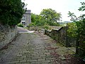
 Sowerby Bridge FP98 (3) - Leaving Long Causeway - geograph.org.uk - 5142486.jpg 2,000 × 1,500; 871 KB
-

-
 Sowerby Bridge FP98 - geograph.org.uk - 4638712.jpg 2,048 × 1,536; 1.12 MB
-
 Sowerby Bridge FP98 - geograph.org.uk - 4638718.jpg 2,048 × 1,536; 718 KB
-
 Sowerby Bridge FP98 - geograph.org.uk - 4638724.jpg 1,444 × 1,960; 920 KB
-
 Sowerby Bridge FP98 alongside the Woodlands housing estate - geograph.org.uk - 4638708.jpg 2,048 × 1,536; 1.03 MB
-
 Sowerby Bridge FP98 alongside Woodlands - geograph.org.uk - 4638744.jpg 1,464 × 1,968; 860 KB
-
 Sowerby Bridge FP98 at a path junction - geograph.org.uk - 4638352.jpg 2,048 × 1,536; 1.12 MB
-
 Sowerby bridge FP98 at Brock Well Mill - geograph.org.uk - 4638776.jpg 2,016 × 1,494; 848 KB
-
 Sowerby Bridge FP98 at the former Brock Well Mill - geograph.org.uk - 4638768.jpg 2,048 × 1,536; 1,000 KB
-
 Sowerby Bridge FP98 at Woodlands - geograph.org.uk - 4638728.jpg 1,536 × 2,048; 1.13 MB
-

-
 Sowerby Bridge FP98 going down towards the A58 - geograph.org.uk - 4638704.jpg 1,536 × 2,048; 1.03 MB
-
 Sowerby bridge FP98 looking towards Brock Well Lane - geograph.org.uk - 4638748.jpg 2,048 × 1,536; 750 KB
-
 Sowerby Bridge FP98 to the west of Brock Well Mill - geograph.org.uk - 4638763.jpg 1,536 × 2,048; 1.34 MB

_-_Leaving_Long_Causeway_-_geograph.org.uk_-_5142486.jpg)
_-_Approaching_the_stile_at_Haven_-_geograph.org.uk_-_5142509.jpg)


