Category:Spanish and Mexican Land Grants in the United States
ranch created by land grant by Spain and Mexico in the 18th and 19th centuries in California and Baja California | |||||
| Upload media | |||||
| Subclass of | |||||
|---|---|---|---|---|---|
| Location |
| ||||
| |||||
English: Land grants — of the Spanish colonial New Spain (1769-1821) and post-independence Mexico (1821-1846).
- Formerly located in areas of present day California, and the Southwestern United States.
- For more information, see the Wikipedia articles Ranchos of California and List of Ranchos of California.
Subcategories
This category has the following 13 subcategories, out of 13 total.
A
C
- Rancho Camulos (55 F)
- Centinela Adobe (10 F)
E
- Rancho Los Encinos (14 F)
G
P
- Rancho Petaluma Adobe (53 F)
R
- Rios-Caledonia Adobe (22 F)
- Rómulo Pico Adobe (11 F)
S
- Rancho Sespe (28 F)
- Rancho Simi (3 F)
Y
- Yorba Hacienda (2 F)
Media in category "Spanish and Mexican Land Grants in the United States"
The following 11 files are in this category, out of 11 total.
-
-
 BacaView.jpg 1,632 × 1,088; 510 KB
-
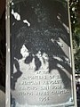 Plaque about Rancho San Jose de Buenos Ayres in Holmby Park, Los Angeles, CA.JPG 3,240 × 4,320; 4.67 MB
-
 Casa de los Cerritos, 4600 American Avenue, Long Beach (Los Angeles County, California).jpg 4,363 × 2,618; 2.24 MB
-

-

-

-
-
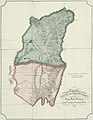
 Nell's topographical map of the State of Colorado - DPLA - 85d3ef6e49f097898024f51da220cd9c.jpg 8,999 × 7,035; 14.44 MB
-
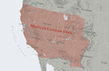 Mexican Cession.png 2,328 × 1,541; 2.81 MB
-
 Opuntia species.jpg 3,264 × 2,448; 1.49 MB


.jpg)


