Category:Spinnerei an der Lorze, Baar
| Object location | | View all coordinates using: OpenStreetMap |
|---|
industrial buildings in Baar in the canton of Zug, Switzerland  | |||||
| Upload media | |||||
| Instance of | |||||
|---|---|---|---|---|---|
| Part of | |||||
| Location |
| ||||
| Street address |
| ||||
| Heritage designation | |||||
 | |||||
Media in category "Spinnerei an der Lorze, Baar"
The following 11 files are in this category, out of 11 total.
-
 AG Spinnerei an der Lorze 1875.jpg 3,449 × 2,610; 1.61 MB
-
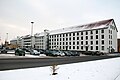
 B-Baar-Spinnerei-Lorze.jpg 1,800 × 1,200; 1.74 MB
-
 Baar Spinnerei an der Lorze 1.jpg 4,288 × 2,848; 10.18 MB
-
 Baar Spinnerei an der Lorze 2.jpg 4,288 × 2,848; 6.01 MB
-
 Baar Spinnerei an der Lorze 3.jpg 4,288 × 2,848; 5.57 MB
-
 Baar Spinnerei an der Lorze Infotafel.jpg 2,848 × 4,288; 7.05 MB
-
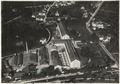 ETH-BIB-Baar, Spinnerei Baar-Inlandflüge-LBS MH03-1164.tif 6,716 × 4,703; 90.37 MB
-
 ETH-BIB-Baar, Spinnerei Baar-Inlandflüge-LBS MH03-1165.tif 6,714 × 4,696; 90.21 MB
-
 Spinnerei an der Lorze 1895.jpg 2,925 × 4,181; 2.24 MB
-
 Spinnerei an der Lorze Aktie 1875.jpg 8,426 × 6,099; 7.43 MB
-
 Spinnerei an der Lorze-Aktie 1875 Statuten.jpg 3,937 × 5,733; 2.45 MB


