Category:St. Augustin (Neuburg an der Donau)
This is the category of the Bavarian Baudenkmal (cultural heritage monument) with the ID D-1-85-149-89 (Wikidata)
|
| Object location | | View all coordinates using: OpenStreetMap |
|---|
human settlement  | |||||
| Upload media | |||||
| Instance of | |||||
|---|---|---|---|---|---|
| Location | Neuburg an der Donau, Neuburg-Schrobenhausen, Upper Bavaria, Bavaria, Germany | ||||
| Street address |
| ||||
| Has part(s) |
| ||||
| Heritage designation | |||||
 | |||||
Media in category "St. Augustin (Neuburg an der Donau)"
The following 16 files are in this category, out of 16 total.
-
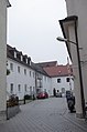 Klosterhof, St. Augustin (Neuburg an der Donau).jpg 3,264 × 4,928; 6.09 MB
-
 Neuburg a D ehem Franziskanerk' St. Augustin - 1.jpg 4,032 × 2,268; 8.34 MB
-
 Neuburg a D ehem Franziskanerk' St. Augustin - 2.jpg 2,268 × 4,032; 2.88 MB
-
 Neuburg a D ehem Franziskanerk' St. Augustin - 3.jpg 2,268 × 4,032; 2.29 MB
-
 Neuburg a D ehem Franziskanerk' St. Augustin - 4.jpg 4,032 × 2,268; 6.09 MB
-
 Neuburg a D ehem Franziskanerk' St. Augustin - 5.jpg 2,268 × 4,032; 3.73 MB
-
 Neuburg a D ehem Franziskanerk' St. Augustin - 6.jpg 2,268 × 4,032; 4.28 MB
-
 Neuburg a D ehem Franziskanerk' St. Augustin - 7.jpg 2,268 × 4,032; 6.25 MB
-
 Neuburg a D ehem Franziskanerk' St. Augustin - 8.jpg 2,268 × 4,032; 6.17 MB
-
 Neuburg a D ehem Franziskanerk' St. Augustin - 9.jpg 3,024 × 4,032; 5.15 MB
-
 Neuburg an der Donau, Augustinskirche v O, 1.jpeg 3,072 × 2,112; 1.86 MB
-
 Neuburg Augustinskirche v N, 3.jpeg 2,000 × 2,496; 1.63 MB
-
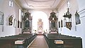
 St. Augustin (Neuburg an der Donau).jpg 3,264 × 4,928; 5.83 MB
-
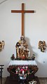
 St.AugustinAltarraum1552.JPG 1,600 × 1,200; 404 KB
-
 StAugustinaußen7287.JPG 1,600 × 1,200; 576 KB
-
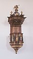
 StAugustinPieta6587.JPG 1,200 × 1,600; 691 KB
.jpg)


.jpg)

