Category:St. Bartholomäus (Rothenstadt)
| Object location | | View all coordinates using: OpenStreetMap |
|---|
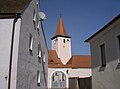
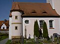
church building in Weiden in der Oberpfalz, Upper Palatinate, Germany  | |||||
| Upload media | |||||
| Instance of | |||||
|---|---|---|---|---|---|
| Location | Rothenstadt, Weiden in der Oberpfalz, Upper Palatinate, Bavaria, Germany | ||||
| Street address |
| ||||
| Heritage designation | |||||
 | |||||
This is the category of the Bavarian Baudenkmal (cultural heritage monument) with the ID D-3-63-000-165 (Wikidata)
|
Media in category "St. Bartholomäus (Rothenstadt)"
The following 4 files are in this category, out of 4 total.
-
 RothenstadtStBartholomaeus 01.jpg 2,304 × 1,704; 760 KB
-
 RothenstadtStBartholomaeus 02.jpg 2,304 × 1,704; 746 KB
-
 RothenstadtStBartholomaeus 03.jpg 2,304 × 1,704; 926 KB
-
 RothenstadtStBartholomaeus 04.jpg 2,304 × 1,704; 942 KB


