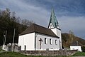
Category:St. Koloman (Oberrohrenstadt)
| Object location | | View all coordinates using: OpenStreetMap |
|---|
building in Berg, Upper Palatinate, Germany  | |||||
| Upload media | |||||
| Instance of | |||||
|---|---|---|---|---|---|
| Location | Berg, Upper Palatinate, Neumarkt, Upper Palatinate, Bavaria, Germany | ||||
| Street address |
| ||||
| Has part(s) |
| ||||
| Heritage designation | |||||
 | |||||
Subcategories
This category has only the following subcategory.
Media in category "St. Koloman (Oberrohrenstadt)"
The following 76 files are in this category, out of 76 total.
-
 D-3-73-113-42 01.jpg 2,304 × 3,456; 2.62 MB
-
 D-3-73-113-42 02.jpg 3,156 × 2,103; 3.2 MB
-
 Pfarrkirche Oberrohrstadt01.JPG 5,184 × 3,456; 14.27 MB
-
 St Kolomann - Oberrohrenstadt NM 001.JPG 6,000 × 4,000; 5.36 MB
-
 St Kolomann - Oberrohrenstadt NM 002.JPG 6,000 × 4,000; 5.09 MB
-
 St Kolomann - Oberrohrenstadt NM 003.JPG 6,000 × 4,000; 5.71 MB
-
 St Kolomann - Oberrohrenstadt NM 004.JPG 4,000 × 6,000; 3.87 MB
-
 St Kolomann - Oberrohrenstadt NM 005.JPG 4,000 × 6,000; 4.92 MB
-
 St Kolomann - Oberrohrenstadt NM 006.JPG 6,000 × 4,000; 7.02 MB
-
 St Kolomann - Oberrohrenstadt NM 008.JPG 4,000 × 6,000; 6.51 MB
-
 St Kolomann - Oberrohrenstadt NM 009.JPG 4,000 × 6,000; 6.44 MB
-
 St Kolomann - Oberrohrenstadt NM 011.JPG 4,000 × 6,000; 6.1 MB
-
 St Kolomann - Oberrohrenstadt NM 012.JPG 4,000 × 6,000; 6.86 MB
-
 St Kolomann - Oberrohrenstadt NM 013.JPG 4,000 × 6,000; 7.66 MB
-
 St Kolomann - Oberrohrenstadt NM 014.JPG 6,000 × 4,000; 7.38 MB
-
 St Kolomann - Oberrohrenstadt NM 015.JPG 4,000 × 6,000; 4.95 MB
-
 St Kolomann - Oberrohrenstadt NM 016.JPG 4,000 × 6,000; 5.41 MB
-
 St Kolomann - Oberrohrenstadt NM 017.JPG 6,000 × 4,000; 6.23 MB
-
 St Kolomann - Oberrohrenstadt NM 018.JPG 4,000 × 6,000; 5.85 MB
-
 St Kolomann - Oberrohrenstadt NM 019.JPG 4,000 × 6,000; 6.2 MB
-
 St Kolomann - Oberrohrenstadt NM 020.JPG 4,000 × 6,000; 5.76 MB
-
 St Kolomann - Oberrohrenstadt NM 021.JPG 4,000 × 6,000; 5.86 MB
-
 St Kolomann - Oberrohrenstadt NM 022.JPG 4,000 × 6,000; 7.22 MB
-
 St Kolomann - Oberrohrenstadt NM 023.JPG 4,000 × 6,000; 6.38 MB
-
 St Kolomann - Oberrohrenstadt NM 024.JPG 4,000 × 6,000; 6.11 MB
-
 St Kolomann - Oberrohrenstadt NM 025.JPG 4,000 × 6,000; 5.78 MB
-
 St Kolomann - Oberrohrenstadt NM 026.JPG 6,000 × 4,000; 6.51 MB
-
 St Kolomann - Oberrohrenstadt NM 027.JPG 6,000 × 4,000; 7.42 MB
-
 St Kolomann - Oberrohrenstadt NM 028.JPG 4,000 × 6,000; 5.6 MB
-
 St Kolomann - Oberrohrenstadt NM 029.JPG 4,000 × 6,000; 5.02 MB
-
 St Kolomann - Oberrohrenstadt NM 030.JPG 6,000 × 4,000; 5.33 MB
-
 St Kolomann - Oberrohrenstadt NM 031.JPG 4,000 × 6,000; 6.13 MB
-
 St Kolomann - Oberrohrenstadt NM 032.JPG 4,000 × 6,000; 5.06 MB
-
 St Kolomann - Oberrohrenstadt NM 033.JPG 4,000 × 6,000; 5.78 MB
-
 St Kolomann - Oberrohrenstadt NM 034.JPG 6,000 × 4,000; 6.69 MB
-
 St Kolomann - Oberrohrenstadt NM 035.JPG 4,000 × 6,000; 6.34 MB
-
 St Kolomann - Oberrohrenstadt NM 036.JPG 6,000 × 4,000; 6.85 MB
-
 St Kolomann - Oberrohrenstadt NM 037.JPG 4,000 × 6,000; 6.78 MB
-
 St Kolomann - Oberrohrenstadt NM 038.JPG 4,000 × 6,000; 5.76 MB
-
 St Kolomann - Oberrohrenstadt NM 039.JPG 4,000 × 6,000; 6.7 MB
-
 St Kolomann - Oberrohrenstadt NM 040.JPG 4,000 × 6,000; 6.34 MB
-
 St Kolomann - Oberrohrenstadt NM 041.JPG 4,000 × 6,000; 6.81 MB
-
 St Kolomann - Oberrohrenstadt NM 042.JPG 4,000 × 6,000; 5.21 MB
-
 St Kolomann - Oberrohrenstadt NM 043.JPG 4,000 × 6,000; 5.5 MB
-
 St Kolomann - Oberrohrenstadt NM 044.JPG 4,000 × 6,000; 4.72 MB
-
 St Kolomann - Oberrohrenstadt NM 045.JPG 4,000 × 6,000; 5.4 MB
-
 St Kolomann - Oberrohrenstadt NM 046.JPG 6,000 × 4,000; 5.66 MB
-
 St Kolomann - Oberrohrenstadt NM 047.JPG 6,000 × 4,000; 6.06 MB
-
 St Kolomann - Oberrohrenstadt NM 048.JPG 6,000 × 4,000; 6.72 MB
-
 St Kolomann - Oberrohrenstadt NM 049.JPG 6,000 × 4,000; 6.47 MB
-
 St Kolomann - Oberrohrenstadt NM 050.JPG 6,000 × 4,000; 6.48 MB
-
 St Kolomann - Oberrohrenstadt NM 051.JPG 6,000 × 4,000; 6.5 MB
-
 St Kolomann - Oberrohrenstadt NM 052.JPG 6,000 × 4,000; 6.57 MB
-
 St Kolomann - Oberrohrenstadt NM 053.JPG 6,000 × 4,000; 5.72 MB
-
 St Kolomann - Oberrohrenstadt NM 054.JPG 6,000 × 4,000; 6.07 MB
-
 St Kolomann - Oberrohrenstadt NM 055.JPG 4,000 × 6,000; 6.02 MB
-
 St Kolomann - Oberrohrenstadt NM 056.JPG 6,000 × 4,000; 6.58 MB
-
 St Kolomann - Oberrohrenstadt NM 057.JPG 6,000 × 4,000; 5.06 MB
-
 St Kolomann - Oberrohrenstadt NM 058.JPG 4,000 × 6,000; 3.87 MB
-
 St Kolomann - Oberrohrenstadt NM 059.JPG 4,000 × 6,000; 4.79 MB
-
 St Kolomann - Oberrohrenstadt NM 060.JPG 4,000 × 6,000; 5.69 MB
-
 St Kolomann - Oberrohrenstadt NM 061.JPG 4,000 × 6,000; 3.82 MB
-
 St Kolomann - Oberrohrenstadt NM 062.JPG 4,000 × 6,000; 5.31 MB
-
 St Kolomann - Oberrohrenstadt NM 063.jpg 6,000 × 4,000; 4.1 MB
-
 St Kolomann - Oberrohrenstadt NM 064.jpg 4,000 × 6,000; 4.38 MB
-
 St Kolomann - Oberrohrenstadt NM 065.jpg 4,000 × 6,000; 4.32 MB
-
 St Kolomann - Oberrohrenstadt NM 066.jpg 6,000 × 4,000; 4.35 MB
-
 St Kolomann - Oberrohrenstadt NM 067.jpg 4,000 × 6,000; 4.08 MB
-
 St Kolomann - Oberrohrenstadt NM 068.jpg 7,728 × 5,152; 9.09 MB
-
 St Kolomann - Oberrohrenstadt NM 069.jpg 5,152 × 7,728; 9.91 MB
-
 St Kolomann - Oberrohrenstadt NM 070.jpg 7,728 × 5,152; 9.25 MB
-
 St Kolomann - Oberrohrenstadt NM 071.jpg 7,728 × 5,152; 9.35 MB
-
 St Kolomann - Oberrohrenstadt NM 072.jpg 5,152 × 7,728; 9.6 MB
-
 St Kolomann - Oberrohrenstadt NM 073.jpg 7,728 × 5,152; 10.66 MB
-
 St Kolomann - Oberrohrenstadt NM 074.jpg 5,152 × 7,728; 8.01 MB
-
 St Kolomann - Oberrohrenstadt NM 075.jpg 5,152 × 7,728; 8.61 MB


