Category:St. Michael (Bremen-Grohn)
| Object location | | View all coordinates using: OpenStreetMap |
|---|
church building in Vegesack, Germany  | |||||
| Upload media | |||||
| Instance of | |||||
|---|---|---|---|---|---|
| Named after | |||||
| Location | Vegesack, Bremen-Nord, Bremen, Germany | ||||
| Street address |
| ||||
| Architectural style | |||||
| Architect | |||||
| Heritage designation | |||||
 | |||||
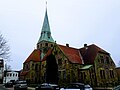
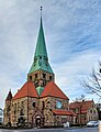
English: Lutheran St. Michael's Church in Grohn, Bremen
Deutsch: Ev.-luth. St. Michaelskirche in Bremen-Grohn.
The object shown is a protected cultural monument in the Free Hanseatic City of Bremen with the number 1279 registered with the State Office for Monument Preservation. → Datenbankeintrag
Media in category "St. Michael (Bremen-Grohn)"
The following 5 files are in this category, out of 5 total.
-
 20180210 141942-EFFECTS.jpg 4,128 × 3,096; 1.73 MB
-
 20180212 145028-EFFECTS.jpg 3,047 × 3,705; 1.01 MB
-
 Bremen-Vegesack-Grohn St-Michael 01.jpg 960 × 1,280; 463 KB
-
 Gron.jpg 3,125 × 4,632; 8.82 MB
-
 Kirche Grohn 27122022.jpg 723 × 942; 356 KB


