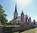
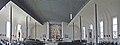
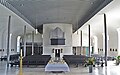
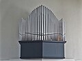
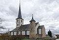
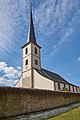
Category:St. Michael (Heustreu)
| Object location | | View all coordinates using: OpenStreetMap |
|---|
cultural heritage monument D-6-73-133-32 (0) in Heustreu, Bavaria   | |||||
| Upload media | |||||
| Instance of | |||||
|---|---|---|---|---|---|
| Location | Heustreu, Rhön-Grabfeld, Lower Franconia, Bavaria, Germany | ||||
| Street address |
| ||||
| Has part(s) |
| ||||
| Heritage designation | |||||
 | |||||
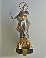
Media in category "St. Michael (Heustreu)"
The following 26 files are in this category, out of 26 total.
-
 Heustreu St. Michael 01.jpg 3,833 × 3,423; 2.7 MB
-
 Heustreu St. Michael 02.jpg 6,872 × 2,584; 2.26 MB
-
 Heustreu St. Michael 03.jpg 4,096 × 2,568; 1.64 MB
-
 Heustreu St. Michael 04.jpg 3,648 × 2,736; 1.18 MB
-
 Heustreu St. Michael 05.jpg 2,760 × 3,504; 1.12 MB
-
 Heustreu St. Michael 06.jpg 2,760 × 3,504; 1,010 KB
-
 Heustreu St. Michael 07.jpg 2,760 × 3,504; 1.48 MB
-
 Heustreu St. Michael 08.jpg 2,760 × 3,504; 1.29 MB
-
 Heustreu St. Michael 09.jpg 2,760 × 3,504; 1.01 MB
-
 Heustreu St. Michael 10.jpg 2,665 × 3,504; 970 KB
-
 Heustreu St. Michael 11.jpg 2,832 × 2,720; 965 KB
-
 Heustreu St. Michael 12.jpg 2,832 × 2,720; 1.51 MB
-
 Heustreu, St. Michael, 001.jpg 3,264 × 4,928; 7.28 MB
-
 Heustreu, St. Michael, 002.jpg 4,928 × 3,307; 2.09 MB
-
 Heustreu, St. Michael, 003.jpg 3,247 × 4,902; 7.04 MB
-
 Heustreu, St. Michael, 004.jpg 3,264 × 4,928; 11.23 MB
-
 Heustreu, St. Michael, 005.jpg 3,264 × 4,928; 11.92 MB
-
 Innenansicht Kirche Heustreu23052017.JPG 4,980 × 3,320; 8.6 MB
-
 Kirche Heustreu23052017.JPG 3,174 × 4,761; 8.49 MB
-
 Wetterstraße 2, Kirche St. Michael, Kirchenburg Heustreu 20210320 001.jpg 3,518 × 5,270; 14.68 MB
-
 Wetterstraße 2, Kirche St. Michael, Kirchenburg Heustreu 20210320 002.jpg 6,016 × 4,016; 25.96 MB
-
 Wetterstraße 2, Kirche St. Michael, Kirchenburg Heustreu 20210320 003.jpg 4,016 × 6,016; 22.3 MB
-
 Wetterstraße 2, Kirche St. Michael, Kirchenburg Heustreu 20210320 004.jpg 5,906 × 3,943; 29.95 MB
-
 Wetterstraße 2, Kirche St. Michael, Kirchenburg Heustreu 20210320 005.jpg 5,906 × 3,943; 25.91 MB
-
 Wetterstraße 2, Kirche St. Michael, Kirchenburg Heustreu 20210320 006.jpg 3,943 × 5,906; 21.85 MB
-
 Wetterstraße 2, Kirche St. Michael, Kirchenburg Heustreu 20210320 007.jpg 2,886 × 4,323; 14.17 MB


