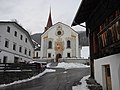
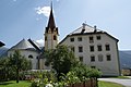
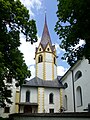
Category:St. Stephanus (Anras)
| Object location | | View all coordinates using: OpenStreetMap |
|---|
church building in Anras, Austria  | |||||
| Upload media | |||||
| Instance of | |||||
|---|---|---|---|---|---|
| Location | Anras, Lienz District, Tyrol, Austria | ||||
| Heritage designation | |||||
 | |||||
|
This category shows the remarkable cultural object in the Austrian state of Tyrol listed by the Tyrolean Art Cadastre with the ID
16741. (on tirisMaps, pdf, more images on Commons, Wikidata) |
Subcategories
This category has only the following subcategory.
I
Media in category "St. Stephanus (Anras)"
The following 9 files are in this category, out of 9 total.
-
 20050825110DR Anras (Tirol Österreich) Pflegegerichtshaus.jpg 2,569 × 2,037; 2.44 MB
-
 20050825120DR Anras (Tirol Österreich) Pflegegerichtshaus.jpg 2,587 × 1,869; 2.56 MB
-
 20050825150DR Anras (Tirol Österreich) Kirche St Stephanus.jpg 1,911 × 2,782; 2.65 MB
-
 Anras-St Stephan.JPG 3,648 × 2,736; 1.98 MB
-
 GuentherZ 2000-08 0068 Anras Osttirol St Stephan.jpg 3,600 × 2,358; 1.32 MB
-
 Schloss Anras.jpg 1,920 × 1,280; 1.57 MB
-
 St. Stephanus (Anras)-01.jpg 3,240 × 4,320; 4.67 MB
-
 St. Stephanus (Anras)-02.jpg 4,190 × 3,143; 7.04 MB
-
 St. Stephanus (Anras)-03-Portal.jpg 3,240 × 4,320; 5.45 MB
_Pflegegerichtshaus.jpg)
_Pflegegerichtshaus.jpg)
_Kirche_St_Stephanus.jpg)


-01.jpg)
-02.jpg)
-03-Portal.jpg)