Category:St Cecilia's church, Tuebrook
| Object location | | View all coordinates using: OpenStreetMap |
|---|
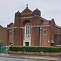
Catholic church building in Liverpool, UK  | |||||
| Upload media | |||||
| Instance of | |||||
|---|---|---|---|---|---|
| Location | Liverpool, Merseyside, North West England, England | ||||
| Heritage designation |
| ||||
 | |||||
Media in category "St Cecilia's church, Tuebrook"
The following 6 files are in this category, out of 6 total.
-
 10 St Cecilia.jpg 1,794 × 1,794; 778 KB
-
 St Cecilia's club, Green Lane.jpg 4,982 × 2,832; 7.24 MB
-
 St Cecilia's, Green Lane 1.jpg 3,300 × 2,979; 5.54 MB
-
 St Cecilia's, Green Lane 2.jpg 3,674 × 2,734; 5.76 MB
-
 St Cecilia's, Green Lane 3.jpg 3,877 × 3,052; 5.91 MB
-
 St Cecilia's, Green Lane 4.jpg 4,332 × 3,572; 9.36 MB


