Category:St John's Gardens, Manchester
 | |||||
| Upload media | |||||
 | |||||
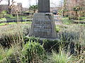
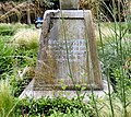
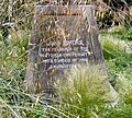
English: St John's Gardens in central Manchester, England, lies between Lower Byrom Street, Byrom Street and Quay Street. Previously occupied by St John's Church and its graveyard between 1769 and 1931, the site was redeveloped into a formal garden in 1932. It contains a central memorial to the church and those buried in its graveyard, whose tombstones have been covered over by of soil except for that of John Owens, founder of Owens College.
Media in category "St John's Gardens, Manchester"
The following 20 files are in this category, out of 20 total.
-
 A new bench in St John's Gardens - geograph.org.uk - 5964253.jpg 1,280 × 1,080; 1.41 MB
-
 Corner wall of St Johns Garden Manchester - geograph.org.uk - 5261418.jpg 1,024 × 683; 211 KB
-
 Memorial bench in St John's Gardens - geograph.org.uk - 5964256.jpg 1,280 × 960; 1.04 MB
-
 Monument to St John's Church, Manchester (1).jpg 3,456 × 4,608; 6.95 MB
-
 Monument to St John's Church, Manchester (2).jpg 4,608 × 3,456; 7.79 MB
-
 St John's Cross - geograph.org.uk - 5625845.jpg 1,280 × 1,342; 1.52 MB
-
 St John's Cross, Base inscription (1) - geograph.org.uk - 5625850.jpg 1,280 × 1,082; 1.45 MB
-
 St John's Cross, Base inscription (2) - geograph.org.uk - 5625872.jpg 1,280 × 1,146; 1.63 MB
-
 St John's Cross, Base inscription (3) - geograph.org.uk - 5625875.jpg 1,280 × 1,060; 1.48 MB
-
 St John's Cross, Base inscription (4) - geograph.org.uk - 5625882.jpg 1,280 × 1,157; 1.7 MB
-
 St John's Gardens - geograph.org.uk - 5625842.jpg 1,280 × 960; 1.01 MB
-
 St John's Gardens - geograph.org.uk - 5625903.jpg 1,280 × 1,707; 1.52 MB
-
 St John's Gardens, Manchester (2).jpg 4,608 × 3,456; 6.55 MB
-
 St John's Gardens, Manchester (3).jpg 4,608 × 3,456; 5.09 MB
-
 St John's Gardens, Manchester.jpg 4,608 × 3,456; 6.11 MB
-
 St Johns Garden, Lower Byrom St, Manchester - geograph.org.uk - 5261414.jpg 1,024 × 683; 259 KB
-
 St Johns Park, Byrom Street - geograph.org.uk - 985628.jpg 640 × 480; 126 KB
-
 St John`s gardens - geograph.org.uk - 397555.jpg 640 × 425; 133 KB
-
 Two Bollards At East End Of St Johns Passage.jpg 2,420 × 3,225; 1.36 MB
-
 Two Bollards At West End Of St Johns Passage.jpg 1,782 × 2,375; 962 KB


.jpg)
.jpg)

_-_geograph.org.uk_-_5625850.jpg)
_-_geograph.org.uk_-_5625872.jpg)
_-_geograph.org.uk_-_5625875.jpg)
_-_geograph.org.uk_-_5625882.jpg)


.jpg)
.jpg)


