Category:St Katherine's College, Liverpool
| Object location | | View all coordinates using: OpenStreetMap |
|---|
architectural structure in Liverpool, Merseyside, England, UK  | |||||
| Upload media | |||||
| Instance of | |||||
|---|---|---|---|---|---|
| Location | Liverpool, Merseyside, North West England, England | ||||
| Heritage designation |
| ||||
 | |||||
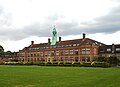
Grade II listed former teacher training college built in the 1930s. Now part of Hope Park campus of Liverpool Hope University.
Media in category "St Katherine's College, Liverpool"
The following 3 files are in this category, out of 3 total.
-
 St Katherine's College, Liverpool-1.jpg 5,152 × 3,864; 8.61 MB
-
 St Katherine's College, Liverpool-2.jpg 4,908 × 3,348; 6.27 MB
-
 St Katherine's College, Liverpool-3.jpg 4,842 × 3,510; 6.79 MB

