Category:St Paul's Cray
area of South East London | |||||
| Upload media | |||||
| Instance of | |||||
|---|---|---|---|---|---|
| Location | London Borough of Bromley, Greater London, London, England | ||||
 | |||||
Subcategories
This category has the following 6 subcategories, out of 6 total.
B
- St Barnabas' Church, Cray (10 F)
C
H
- Hoblingwell Wood (4 F)
S
- St Paul's Cray Common (8 F)
- St Pauls Cray Library (1 F)
Media in category "St Paul's Cray"
The following 32 files are in this category, out of 32 total.
-
 1-3 Chapmans Lane (geograph 2526919).jpg 3,072 × 2,304; 2.52 MB
-
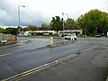
 Allied Bakeries, Orpington - geograph.org.uk - 724931.jpg 640 × 485; 79 KB
-
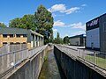
 Banks of the River Cray at St Paul's Cray - geograph.org.uk - 2513431.jpg 4,000 × 3,000; 4.08 MB
-
 Bench by the London Loop - geograph.org.uk - 6027558.jpg 678 × 1,024; 262 KB
-
 Broomwood Road - geograph.org.uk - 6313299.jpg 800 × 600; 98 KB
-
 Chipperfield Road - geograph.org.uk - 6722740.jpg 1,600 × 1,064; 327 KB
-
 Entering Park Wood - geograph.org.uk - 6027447.jpg 678 × 1,024; 286 KB
-
 Field north of Star Lane - geograph.org.uk - 6296432.jpg 1,024 × 768; 273 KB
-
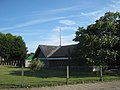 Giggs Hill Church (2) - geograph.org.uk - 2527323.jpg 3,072 × 2,304; 2.06 MB
-
 Hoblingwell Wood - geograph.org.uk - 6027406.jpg 678 × 1,024; 274 KB
-
 Hoblingwell Wood Rec - geograph.org.uk - 6027417.jpg 1,024 × 678; 199 KB
-
 Ivy Cottages, Saint Paul's Cray (01).jpg 4,097 × 3,065; 10.46 MB
-
 Ivy Cottages, Saint Paul's Cray (02).jpg 4,394 × 3,285; 11.48 MB
-
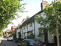
 Ivy Cottages, St Pauls Cray (geograph 2526922).jpg 3,072 × 2,304; 1.95 MB
-
 K-6 Telephone Box in St Paul's Cray (I).jpg 3,268 × 4,372; 14.5 MB
-
 K-6 Telephone Box in St Paul's Cray (II).jpg 3,448 × 4,592; 17.27 MB
-
 K-6 Telephone Box in St Paul's Cray (III).jpg 3,268 × 4,376; 12.91 MB
-
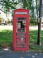
 K6 Telephone Kiosk, St Pauls Cray (geograph 2526928).jpg 3,072 × 2,304; 2.54 MB
-
 Major Oak in Park Wood - geograph.org.uk - 6027459.jpg 678 × 1,024; 298 KB
-
 McDonald's, St Paul's Cray - geograph.org.uk - 6313296.jpg 800 × 600; 123 KB
-
 Mistletoe and Hoblingwell Rec - geograph.org.uk - 6027439.jpg 678 × 1,024; 180 KB
-
 Moss ^ Fungi in Hoblingwell Wood - geograph.org.uk - 6027409.jpg 1,024 × 678; 251 KB
-
 Pond in Irish Wood - geograph.org.uk - 6027569.jpg 1,024 × 439; 187 KB
-
 River Cray and Tree in Saint Paul's Cray.jpg 4,592 × 3,448; 17.62 MB
-
 River Cray north of Main Road, St Paul's Cray.jpg 4,592 × 3,448; 13.02 MB
-
 Sanderson Hall - geograph.org.uk - 6319920.jpg 800 × 600; 148 KB
-
 Sanderson Hall, St Pauls Cray - geograph.org.uk - 2527318.jpg 3,072 × 2,304; 1.91 MB
-
 Scadbury Park Nature Reserve - geograph.org.uk - 6027477.jpg 1,024 × 442; 187 KB
-
 Shoreham Road - geograph.org.uk - 6723023.jpg 1,600 × 1,064; 482 KB
-
 Towards Chorleywood Crescent - geograph.org.uk - 6027423.jpg 678 × 1,024; 187 KB
-
 View NNE from Star Lane - geograph.org.uk - 6296438.jpg 1,024 × 684; 213 KB
-
 War Memorial in St Paul's Cray.jpg 3,265 × 4,106; 10.79 MB
.jpg)


_-_geograph.org.uk_-_2527323.jpg)


.jpg)
.jpg)
.jpg)
.jpg)
.jpg)
.jpg)
.jpg)


