Category:St Philip Neri, Liverpool
| Object location | | View all coordinates using: OpenStreetMap |
|---|
grade II* listed church in Liverpool, UK .JPG) | |||||
| Upload media | |||||
| Instance of | |||||
|---|---|---|---|---|---|
| Location | Liverpool, Merseyside, North West England, England | ||||
| Heritage designation |
| ||||
 | |||||
Subcategories
This category has the following 2 subcategories, out of 2 total.
D
S
Media in category "St Philip Neri, Liverpool"
The following 15 files are in this category, out of 15 total.
-
 Church, corner of Catharine Street and Falkner Street (109160025).jpg 1,926 × 1,288; 1.03 MB
-
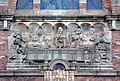 Last Supper frieze, St Philip Neri.jpg 4,704 × 3,167; 16.74 MB
-
 Madonna and Child relief, St Philip Neri.jpg 3,856 × 3,147; 15.78 MB
-
 St Philip Neri 2016.jpg 3,680 × 2,968; 4.3 MB
-
 St Philip Neri 2017-2.jpg 3,324 × 3,166; 4.91 MB
-
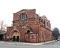 St Philip Neri 2017-3.jpg 3,747 × 3,044; 6.09 MB
-
 St Philip Neri 2017-4.jpg 3,406 × 3,222; 4.79 MB
-
 St Philip Neri 2021.jpg 4,478 × 2,936; 11.99 MB
-

-
 St Philip Neri, Catherine Street, Liverpool (1).JPG 3,456 × 4,608; 3.49 MB
-
 St Philip Neri, Catherine Street, Liverpool (2).JPG 4,608 × 3,456; 3.35 MB
-
 St Philip Neri, Catherine Street, Liverpool (3).JPG 4,608 × 3,456; 3.43 MB
-
 St Phillip Neri.JPG 1,984 × 1,488; 676 KB
-
 St. Philip Neri church, Catharine Street (109160306).jpg 1,471 × 1,485; 902 KB
-
 West end of St Philip Neri 2021.jpg 4,156 × 3,288; 11.57 MB
.jpg)


.JPG)
.JPG)

.jpg)
